Collbran, Colorado

Last updated

Collbran, Colorado
DSCN3546 downtowncollbran e 600.jpg
Main Street in downtown Collbran
Motto(s): 
"Preserving the Past, Conserving the Future."
Mesa County Colorado Incorporated and Unincorporated areas Collbran Highlighted 0815605.svg
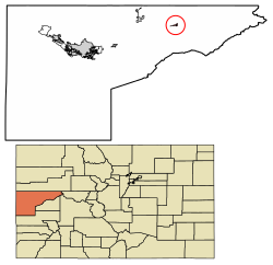
Location of the Town of Collbran in the Mesa County, Colorado.
Usa edcp location map.svg
Red pog.svg
Collbran
Location of the Town of Collbran in the United States.
Coordinates: 39°14′24″N107°57′49″W / 39.24000°N 107.96361°W / 39.24000; -107.96361 [2]
Country Flag of the United States.svg  United States
State Flag of Colorado.svg  Colorado
County Mesa County [1]
Incorporated July 22, 1908 [3]
Government
  Type Statutory town [1]
Area
[4]
  Total0.558 sq mi (1.446 km2)
  Land0.558 sq mi (1.446 km2)
  Water0.000 sq mi (0.000 km2)
Elevation
[2]
5,975 ft (1,821 m)
Population
 (2020) [4]
  Total369
  Density661/sq mi (255/km2)
   Metro
155,703
Time zone UTC−07:00 (MST)
  Summer (DST) UTC−06:00 (MDT)
ZIP Code [5]
81624
Area code 970
FIPS code 08-15605
GNIS feature ID2413226 [2]
Website www.colorado.gov/townofcollbran

Collbran is a statutory town located in Mesa County, Colorado, United States. [1] The town's population was 369 at the 2020 Census. [4] Collbran is a part of the Grand Junction, CO Metropolitan Statistical Area.

Contents

Description

Main Street in downtown Collbran DSCN3545 downtowncollbran e 600.jpg
Main Street in downtown Collbran

The town is located east of Grand Junction along Plateau Creek, at the upper (eastern) end of the small cattle ranching valley around the creek known as the Plateau Valley. The largest community in the valley, it serves a civic and economic center for the surrounding area, which is dependent not only ranching, but on pass-through tourism during the summer and autumn months. In the latter capacity, the town acts somewhat as a gateway to nearby Vega State Park and other recreational sites along the northeast side of the Grand Mesa via the Grand Mesa Scenic and Historic Byway.

Geography

The 2020 United States census recorded the town as having a total area of 357 acres (1.446 km2), all of it land. [4]

Demographics

Historical population
CensusPop.Note
1910 156
1920 28683.3%
1930 34119.2%
1940 301−11.7%
1950 237−21.3%
1960 31030.8%
1970 225−27.4%
1980 34452.9%
1990 228−33.7%
2000 38870.2%
2010 70882.5%
2020 369−47.9%
U.S. Decennial Census

As of the 2000 Census, [6] there were 388 people, 145 households, and 100 families residing in the town. The population density was 777.1 inhabitants per square mile (300.0/km2). There were 161 housing units at an average density of 322.5 per square mile (124.5/km2). The racial makeup of the town was 98.20% White, 0.26% Native American, 0.77% from other races, and 0.77% from two or more races. Hispanic or Latino of any race were 4.12% of the population.

There were 145 households, out of which 36.6% had children under the age of 18 living with them, 53.8% were married couples living together, 9.7% had a female householder with no husband present, and 31.0% were non-families. 27.6% of all households were made up of individuals, and 12.4% had someone living alone who was 65 years of age or older. The average household size was 2.50 and the average family size was 3.03.

In the town, the population was spread out, with 29.6% under the age of 18, 3.6% from 18 to 24, 26.8% from 25 to 44, 23.5% from 45 to 64, and 16.5% who were 65 years of age or older. The median age was 38 years. For every 100 females, there were 87.4 males. For every 100 females age 18 and over, there were 84.5 males.

The median income for a household in the town was $32,500, and the median income for a family was $36,016. Males had a median income of $28,438 versus $27,917 for females. The per capita income for the town was $17,080. About 5.9% of families and 14.7% of the population were below the poverty line, including 17.2% of those under age 18 and 8.0% of those age 65 or over.

Climate

The Köppen climate classification subtype for this climate is "Dfb" (Warm Summer Continental Climate). [7]

Climate data for Collbran, Colorado
MonthJanFebMarAprMayJunJulAugSepOctNovDecYear
Average high °C (°F)2
(35)
5
(41)
10
(50)
15
(59)
21
(69)
27
(80)
30
(86)
29
(84)
24
(75)
18
(64)
9
(48)
3
(37)
16
(60)
Average low °C (°F)−12
(10)
−9
(15)
−5
(23)
0
(32)
3
(37)
7
(44)
10
(50)
9
(48)
5
(41)
0
(32)
−6
(21)
−11
(12)
0
(32)
Average precipitation mm (inches)28
(1.1)
28
(1.1)
38
(1.5)
38
(1.5)
38
(1.5)
20
(0.8)
28
(1.1)
36
(1.4)
38
(1.5)
38
(1.5)
28
(1.1)
25
(1)
380
(15)
Source: Weatherbase [8]

See also

Related Research Articles

<span class="mw-page-title-main">Mesa County, Colorado</span> County in Colorado, United States

Mesa County is a county located in the U.S. state of Colorado. As of the 2020 census, the population was 155,703. The county seat and most populous municipality is Grand Junction. The county was named for the many large mesas in the area, including the Grand Mesa, which is the largest flat-topped mountain in the world.

<span class="mw-page-title-main">Brookwood, Alabama</span> City in Alabama, United States

Brookwood is a city in Tuscaloosa County, Alabama, United States. It incorporated in September 1977. As of the 2020 census, the population of the town is 2,504.

<span class="mw-page-title-main">Chatom, Alabama</span> City in and county seat of Washington County, Alabama

Chatom is a town in Washington County, Alabama, United States. It incorporated in 1949. Chatom is the county seat of Washington County, holding the distinction since 1907. The town's population was 1,288 At the 2010 census, up from 1,193 in 2000.

<span class="mw-page-title-main">Lake Montezuma, Arizona</span> CDP in Yavapai County, Arizona

Lake Montezuma is a census-designated place (CDP) in Yavapai County in the U.S. state of Arizona. The population was 5,111 at the 2020 census. The CDP includes the communities of Rimrock and McGuireville. Located along Interstate 17, it is 20 miles (32 km) south of Sedona and 8 miles (13 km) north of Camp Verde in central Arizona's Verde Valley.

<span class="mw-page-title-main">Cedaredge, Colorado</span> Town in Colorado, United States

The Town of Cedaredge is a home rule municipality located in Delta County, Colorado, United States. The town population was 2,279 at the 2020 United States Census. Cedaredge sits in the Surface Creek Valley beneath the southern slopes of the Grand Mesa, the largest mesa in the world. Its elevated vantage point affords southern views of the San Juan Mountains, the Black Canyon of the Gunnison National Park, and the communities of Delta, Olathe, and Montrose. Cedaredge is a small, agricultural community which produces beef cattle, elk, apples, peaches, and wine from the region's few basic vineyards. Tourist attractions include Cedaredge Golf Club, Historic Pioneer Town, and an art gallery and craft store housed in a renovated apple packing shed.

<span class="mw-page-title-main">Crawford, Colorado</span> Town in Colorado, United States

The Town of Crawford is a Statutory Town in Delta County, Colorado, United States. The town population was 403 at the 2020 United States Census. The surrounding mesas and valleys support a farming and ranching community.

<span class="mw-page-title-main">Gypsum, Colorado</span> Town in Colorado, United States

The Town of Gypsum is the home rule municipality that is the most populous municipality in Eagle County, Colorado, United States. The town population was 8,040 at the 2020 United States Census, a +24.13% increase since the 2010 United States Census. Gypsum is a part of the Edwards, CO Micropolitan Statistical Area. Gypsum is the home of an American Gypsum drywall plant and mine.

<span class="mw-page-title-main">Rifle, Colorado</span> City in Colorado, United States

Rifle is a home rule municipality in and the most populous community of Garfield County, Colorado, United States. The population was 10,437 at the 2020 census. Rifle is a regional center of the cattle ranching industry located along Interstate 70 and the Colorado River just east of the Roan Plateau, which dominates the western skyline of the town. The town was founded in 1882 by Abram Maxfield, and was incorporated in 1905 along Rifle Creek, near its mouth on the Colorado. The community takes its name from the creek.

<span class="mw-page-title-main">Granby, Colorado</span> Town in Colorado, United States

The Town of Granby is the Statutory Town that is the most populous municipality in Grand County, Colorado, United States. The town population was 2,079 at the 2020 United States Census. Granby is situated along U.S. Highway 40 in the Middle Park basin, and it is about 85 miles (137 km) northwest of Denver and 14 miles (23 km) southwest of Rocky Mountain National Park.

<span class="mw-page-title-main">De Beque, Colorado</span> Town in Colorado, United States

De Beque is a statutory town located in Mesa County, Colorado. The population was 493 at the time of the 2020 census. De Beque is a part of the Grand Junction, CO Metropolitan Statistical Area. The town consists of a small grid, including a historic downtown featuring a town hall, a tavern, and several commercial businesses in historic structures. The surrounding streets include houses, several churches, and a school.

<span class="mw-page-title-main">Palisade, Colorado</span> Town in Mesa County, Colorado, United States

Palisade is a statutory town in Mesa County, Colorado, United States. It is part of the Grand Junction Metropolitan Statistical Area. The population was 2,565 at the 2020 census, down from 2,692 in 2010.

<span class="mw-page-title-main">Mancos, Colorado</span> Town in Colorado, United States

Mancos is a statutory town in Montezuma County, Colorado, United States. The population was 1,196 at the 2020 census, down from 1,336 in 2010.

<span class="mw-page-title-main">Brush, Colorado</span> City in Colorado, United States

Brush is a Statutory City located in Morgan County, Colorado, United States. The city population was 5,339 at the 2020 United States Census. Brush is a part of the Fort Morgan, CO Micropolitan Statistical Area.

<span class="mw-page-title-main">Hillrose, Colorado</span> Town in Colorado, United States

The Town of Hillrose is a statutory town located in Morgan County, Colorado, United States. The town population was 312 at the 2020 United States Census, an 18.18% increase since the 2010 United States Census.

<span class="mw-page-title-main">Hayden, Colorado</span> Town in Colorado, United States

The Town of Hayden is a home rule municipality located in Routt County, Colorado, United States. The town population was 1,941 at the 2020 United States Census. Hayden is a part of the Steamboat Springs, CO Micropolitan Statistical Area. The town sits along U.S. Highway 40 in the Yampa River Valley between Craig and Steamboat Springs. Hayden is located near the Yampa Valley Regional Airport, by which Hayden is one of the smallest communities in the U.S. to have mainline passenger jet service provided by American Airlines, Delta Air Lines, Southwest Airlines and United Airlines on a scheduled basis.

<span class="mw-page-title-main">Fromberg, Montana</span> Town in Carbon County, Montana, United States

Fromberg is a town in Carbon County, Montana, United States. As of the 2020 census, the population of the town was 392.

<span class="mw-page-title-main">Gardnerville, Nevada</span> Unincorporated town in the State of Nevada, United States

Gardnerville is an unincorporated town in Douglas County, Nevada, adjacent to the county seat of Minden. The population was 6,211 at the 2020 census.

<span class="mw-page-title-main">New Harmony, Utah</span> Town in the state of Utah, United States

New Harmony is a town in northern Washington County, Utah, United States. The population was 207 at the 2010 census.

<span class="mw-page-title-main">Hamlin, West Virginia</span> Town in West Virginia, United States

Hamlin is a town in and the county seat of Lincoln County, West Virginia, United States, along the Mud River. The population was recorded as 1,040 at the 2020 census. It is part of the Huntington–Ashland metropolitan area.

<span class="mw-page-title-main">St. Germain, Wisconsin</span> Town in Wisconsin, United States

St. Germain is a town in Vilas County, Wisconsin, United States. The population was 1,932 at the 2000 census. The unincorporated community of St. Germain is located in the town.

References

  1. 1 2 3 4 "Active Colorado Municipalities". Colorado Department of Local Affairs . Retrieved October 15, 2021.
  2. 1 2 3 U.S. Geological Survey Geographic Names Information System: Collbran, Colorado
  3. "Colorado Municipal Incorporations". State of Colorado, Department of Personnel & Administration, Colorado State Archives. December 1, 2004. Retrieved September 2, 2007.
  4. 1 2 3 4 "Decennial Census P.L. 94-171 Redistricting Data". United States Census Bureau, United States Department of Commerce. August 12, 2021. Retrieved September 7, 2021.
  5. "ZIP Code Lookup". United States Postal Service. Archived from the original (JavaScript/HTML) on September 3, 2007. Retrieved September 5, 2007.
  6. "U.S. Census website". United States Census Bureau . Retrieved January 31, 2008.
  7. Climate Summary for Collbran, Colorado
  8. "Weatherbase.com". Weatherbase. 2013. Retrieved on August 7, 2013.