Related Research Articles
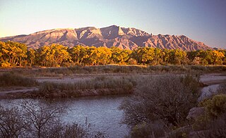
The Sandia Mountains are a mountain range located in Bernalillo and Sandoval counties, immediately to the east of the city of Albuquerque in New Mexico in the southwestern United States. The mountains are just due south of the southern terminus of the Rocky Mountains, and are part of the Sandia–Manzano Mountains. This is largely within the Cibola National Forest and protected as the Sandia Mountain Wilderness. The highest point is Sandia Crest, 10,678 feet (3,255 m).

Sandia Crest, also known locally as Sandia Peak or simply as the Crest, is a mountain ridge that, at 10,679 feet (3,255 m), is the highpoint of the Sandia–Manzano Mountains, and is located in the Sandia Mountains of Bernalillo County, New Mexico, United States. Instead of a true summit or topographic peak, this range climbs to a long ridge line. To the east, the range slopes down from the Crest and merges into the plains below. On the west side of the Crest is a cliff; the range dramatically drops over 4,000 feet in elevation over 2 miles of horizontal distance to the Rio Grande Valley and city of Albuquerque below. It is within the Sandia Ranger District of the Cibola National Forest. The Crest features a viewing area with a shop and visitor center, telecommunications transmitters, the popular La Luz Trail, the Sandia Mountain Wilderness, and the summit of Sandia Peak Ski Area and the Sandia Peak Tramway, which is the longest aerial tramway in the Americas.

The Manzano Mountains are a small mountain range in the central part of the U.S. state of New Mexico. They are oriented north–south and are 30 miles long. The center of the range lies due east of the town of Belen. The name "Manzano" is Spanish for "apple tree"; the mountains were named for apple orchards planted at the nearby town of Manzano.
New Jersey is a very geologically and geographically diverse region in the United States' Middle Atlantic region, offering variety from the Appalachian Mountains and the Highlands in the state's northwest, to the Atlantic Coastal Plain region that encompasses both the Pine Barrens and the Jersey Shore. The state's geological features have impacted the course of settlement, development, commerce and industry over the past four centuries.

The Caballo Mountains, are a mountain range located in Sierra and Doña Ana Counties, New Mexico, United States. The range is located east of the Rio Grande and Caballo Lake, and west of the Jornada del Muerto; the south of the range extends into northwest Doña Ana County. The nearest towns are Truth or Consequences and Hatch.

The Sandia Formation is a geologic formation in New Mexico, United States. Its fossil assemblage is characteristic of the early Pennsylvanian.

The Manzano Group is a group of geologic formations in central New Mexico. These have radiometric ages of 1601 to 1662 million years (Ma), corresponding to the late Statherian period of the Paleoproterozoic.

The Yeso Group is a group of geologic formations in New Mexico. It contains fossils characteristic of the Kungurian Age of the early Permian Period.

The Madera Group is a group of geologic formations in northern New Mexico. Its fossil assemblage dates the formation to the middle to late Pennsylvanian period.
The geology of New Mexico includes bedrock exposures of four physiographic provinces, with ages ranging from almost 1800 million years (Ma) to nearly the present day. Here the Great Plains, southern Rocky Mountains, Colorado Plateau, and Basin and Range Provinces meet, giving the state great geologic diversity.

The Ortega Formation is a geologic formation that crops out in most of the mountain ranges of northern New Mexico. Detrital zircon geochronology establishes a maximum age for the formation of 1690-1670 million years (Mya), in the Statherian period of the Precambrian.

The Marquenas Formation is a geological formation that crops out in the Picuris Mountains of northern New Mexico. Detrital zircon geochronology gives it a maximum age of 1435 million years, corresponding to the Calymmian period.
The Sevilleta Metarhyolite is a geologic formation in central New Mexico. It has a radiometric age of 1665 ± 16 Ma, corresponding to the Statherian period.
The Los Pinos Formation is a geologic formation in northern New Mexico. It was deposited from the late Oligocene through the late Miocene epochs, based on radiometric ages of interbedded lava flows and overlying and underlying formations.
The White Ridge Quartzite is a geologic formation in central New Mexico. It has a maximum age of 1650 million years (Ma), corresponding to the Statherian period.
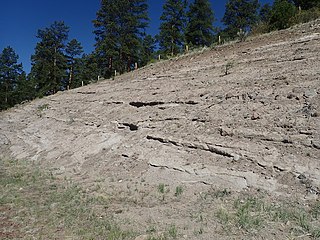
The Blue Springs Formation is a geologic formation exposed in the Los Pinos Mountains of central New Mexico.

The Sais Quartzite is a geologic formation exposed in the Los Pinos Mountains of central New Mexico.

The Abajo Formation is a geologic formation in the Los Pinos Mountains of central New Mexico. It was deposited about 1660 million years (Ma) ago, corresponding to the Statherian period.
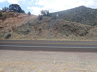
The Tijeras Greenstone is a geologic formation in central New Mexico. It has a radiometric age of 1660 million years (Ma), corresponding to the Statherian period.
The White Ledges Formation is a geologic formation that crops out in central Arizona, US. Detrital zircon geochronology establishes a maximum age for the formation of 1726 million years (Mya), in the Statherian period of the Precambrian. The formation is typical of quartzites deposited around 1650 million years ago in the southwestern part of Laurentia, the ancient core of the North American continent.
References
- 1 2 3 4 Stark, J. T.; Dapples, E. C. (1946). "Geology of the Los Pinos Mountains, New Mexico". Geological Society of America Bulletin. 57 (12): 1121. doi:10.1130/0016-7606(1946)57[1121:GOTLPM]2.0.CO;2.
- 1 2 "Los Pinos Mountains" . Retrieved 24 January 2022.
- 1 2 Holland, Mark E.; Grambling, Tyler A.; Karlstrom, Karl E.; Jones, James V.; Nagotko, Kimberly N.; Daniel, Christopher G. (September 2020). "Geochronologic and Hf-isotope framework of Proterozoic rocks from central New Mexico, USA: Formation of the Mazatzal crustal province in an extended continental margin arc". Precambrian Research. 347: 105820. doi:10.1016/j.precamres.2020.105820.
34°19′59″N106°35′10″W / 34.333°N 106.586°W
| | This article related to a mountain, mountain range, or peak in the United States is a stub. You can help Wikipedia by expanding it. |