Love Valley, North Carolina

Last updated

Love Valley, North Carolina
USA North Carolina location map.svg
Red pog.svg
Love Valley
Usa edcp location map.svg
Red pog.svg
Love Valley
Coordinates: 35°59′15″N80°58′26″W / 35.98750°N 80.97389°W / 35.98750; -80.97389
Country United States
State North Carolina
County Iredell, Alexander
CharteredApril 2, 1963
Founded by Andy Barker
Government
  TypeMayor-council
  MayorTimothy Meadows (R)
Area
[1]
  Total1.02 sq mi (2.65 km2)
  Land1.02 sq mi (2.65 km2)
  Water0.00 sq mi (0.00 km2)
Elevation
[2]
1,476 ft (450 m)
Population
 (2020)
  Total154
  Estimate 
(2023)
160
  Density150.54/sq mi (58.12/km2)
Time zone UTC-5 (Eastern (EST))
  Summer (DST) UTC-4 (EDT)
ZIP code
28625
Area code 704
FIPS code 37-39420 [3]
GNIS feature ID2406050 [2]
Website www.lovevalley.com

Love Valley is a town [4] in Iredell County, North Carolina, United States. It also extends into Alexander County on its western end. The population was 90 at the 2010 census, [5] and in 2020 the estimated population was 154.

Contents

History

Love Valley is a small town located in a remote valley in the Brushy Mountains of northwestern North Carolina. Its creation in 1954 marked the fulfillment of a dream for founder Andy Barker. Barker developed two visions as a young man—he wanted to build a Christian community, and he wanted to be a cowboy. In 1954 he combined those visions to create an Old West-style village in the hills of northwestern Iredell County. The town was incorporated on April 2, 1963. [6] [7] [8]

Modeled after the Old West towns seen in countless Hollywood films, Love Valley boasts a saloon, general store, hitching posts, and rodeos. Automobiles are not allowed inside the town limits; people still use horses and horse-drawn vehicles to travel in the town. A small, nondenominational Christian church sits on a hill overlooking the town, thus emphasizing Barker's vision of a Christian utopia. The town garnered its share of controversy in the 1960s and 1970s, including around the "Love Valley Rock Festival", which local farmers complained brought drug addicts and other "troublemakers" to the area. However, over the last two decades the town has settled down considerably and is now known as a popular gathering spot for horse-lovers and horseback riding. There are miles of horseback riding trails in the surrounding Brushy Mountains. [7] [8]

Geography

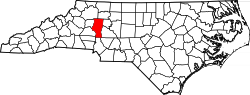
Love Valley is located in the Brushy Mountains of northwestern Iredell County. It is 16 miles (26 km) north of Statesville, the Iredell County seat, and 23 miles (37 km) southeast of Wilkesboro by road through the Brushy Mountains.

According to the United States Census Bureau, the town has a total area of 0.62 square miles (1.6 km2), of which 5,366 square metres (1.3 acres), or 0.33%, are water. [5] The town's area drains southwest to Snow Creek, part of the South Yadkin River watershed.

Demographics

Historical population
CensusPop.Note
1970 40
1980 5537.5%
1990 6721.8%
2000 30−55.2%
2010 90200.0%
2020 15471.1%
U.S. Decennial Census [9]

As of the census [3] of 2010, there were 90 people, 17 households, and 9 families residing in the town. The population density was 450.0 inhabitants per square mile (173.7/km2). There were 31 housing units at an average density of 154.0 per square mile (59.5/km2). The racial makeup of the town is 98.9% White.

There were 17 households, out of which 11.8% had children under the age of 18 living with them, 47.1% were married couples living together, 11.8% had a female householder with no husband present, and 41.2% were non-families. 41.2% of all households were made up of individuals, and 17.6% had someone living alone who was 65 years of age or older. The average household size was 1.76 and the average family size was 2.20.

In the town, the population was spread out, with 6.7% under the age of 18, 6.7% from 18 to 24, 20.0% from 25 to 44, 36.7% from 45 to 64, and 30.0% who were 65 years of age or older. The median age was 55 years. For every 100 females, there were 87.5 males. For every 100 females age 18 and over, there were 86.7 males.

The median income for a household in the town was $24,375, and the median income for a family was $25,313. Males had a median income of $0 versus $0 for females. The per capita income for the town was $9,848. There were 15.4% of families and 31.0% of the population living below the poverty line, including 50.0% of under eighteens and none of those over 64.

See also

Related Research Articles

<span class="mw-page-title-main">Franklin County, Massachusetts</span> County in Massachusetts, United States

Franklin County is a nongovernmental county located in the northwestern part of the U.S. state of Massachusetts. As of the 2020 census, the population was 71,029, which makes it the least-populous county on the Massachusetts mainland, and the third-least populous county in the state. Its traditional county seat and most populous city is Greenfield. Its largest town by area is New Salem. Franklin County comprises the Greenfield Town, MA Micropolitan Statistical Area, which is included in the Springfield-Greenfield Town, MA Combined Statistical Area.

<span class="mw-page-title-main">Iredell County, North Carolina</span> County in North Carolina, United States

Iredell County is a county located in the U.S. state of North Carolina. As of the 2020 census, the population was 186,693. Its county seat is Statesville, and its largest community is Mooresville. The county was formed in 1788, subtracted from Rowan County. It is named for James Iredell, one of the first justices of the Supreme Court. Iredell County is included in the Charlotte-Concord-Gastonia, NC-SC Metropolitan Statistical Area, as defined by the Office of Management and Budget, with data from the U.S. Census Bureau.

<span class="mw-page-title-main">Caldwell County, North Carolina</span> County in North Carolina, United States

Caldwell County is a county in the U.S. state of North Carolina. It is located in the foothills of the Blue Ridge Mountains. As of the 2020 census, the population was 80,652. Its county seat is Lenoir. Caldwell County is part of the Hickory-Lenoir-Morganton, NC Metropolitan Statistical Area.

<span class="mw-page-title-main">Alexander County, North Carolina</span> County in North Carolina, United States

Alexander County is a county established in the U.S. state of North Carolina in 1847. As of the 2020 census, the population was 36,444. Its county seat is Taylorsville. Alexander County is part of the Hickory-Lenoir-Morganton, NC Metropolitan Statistical Area.

<span class="mw-page-title-main">Trinity, Alabama</span> Town in Alabama, United States

Trinity is a town in Morgan County, Alabama, United States. It is included in the Decatur Metropolitan Area and the Huntsville-Decatur Combined Statistical Area. As of the 2020 census, the population of the town was 2,526, up from 2,095 in 2010. It was incorporated in 1901.

<span class="mw-page-title-main">Spring Valley, Kentucky</span> City in Kentucky, United States

Spring Valley is a home rule-class city in Jefferson County, Kentucky, United States. Spring Valley Estates, begun in 1964, remained an unincorporated area until September, 1983. At that time, the City of Spring Valley was established to provide services. The current mayor is Gerri Willis. The population was 654 at the 2010 census. Population has increased to 837 based on the 2020 census.

<span class="mw-page-title-main">Roxbury, New Hampshire</span> Town in New Hampshire, United States

Roxbury is a town in Cheshire County, New Hampshire, United States. The population was 220 at the 2020 census.

<span class="mw-page-title-main">Westford, New York</span> Town in New York, United States

Westford is a town in Otsego County, New York, United States. The population was 868 at the 2010 census. It is southeast of Cooperstown.

<span class="mw-page-title-main">Cajah's Mountain, North Carolina</span> Town in North Carolina, United States

Cajah's Mountain is a town in Caldwell County, North Carolina, United States. The population was 2,823 at the 2010 census. It is part of the Hickory–Lenoir–Morganton Metropolitan Statistical Area.

<span class="mw-page-title-main">East Flat Rock, North Carolina</span> Census-designated place in North Carolina, United States

East Flat Rock is an unincorporated area and census-designated place (CDP) in Henderson County, North Carolina, United States. The population was 4,995 at the 2010 census, up from 4,151 at the 2000 census. It is part of the Asheville Metropolitan Statistical Area.

<span class="mw-page-title-main">Harmony, North Carolina</span> Town in North Carolina, United States

Harmony is a town in Iredell County, North Carolina, United States. The town was incorporated in 1927 and is located in northeastern Iredell County and lies in the eastern portion of the North Carolina High Country. It is primarily located in Turnersburg Township, with its northernmost portion in Eagle Mills Township. The population was 531 at the 2010 census.

<span class="mw-page-title-main">Troutman, North Carolina</span> Town in North Carolina, United States

Troutman is a town in Iredell County, North Carolina, United States. The town is located roughly 35 miles (56 km) north of Charlotte. As of the 2020 census the town's population was 3,698. Due to substantial residential growth in the area, as well as neighborhood annexation, the town is experiencing dramatic population growth. Approved residential developments, when completed, are forecast to increase town population to more than 11,000 residents.

<span class="mw-page-title-main">Pilot Mountain, North Carolina</span> Town in North Carolina, United States

Pilot Mountain is a town in Surry County, North Carolina, United States. The population was 1,443 at the 2020 census. It is named for the nearby landmark of Pilot Mountain, a distinctive geological formation.

<span class="mw-page-title-main">Moravian Falls, North Carolina</span> CDP in North Carolina, United States

Moravian Falls is a census-designated place (CDP) in Wilkes County, North Carolina, United States. The population was 1,712 as of the 2020 census.

<span class="mw-page-title-main">Halifax Township, Pennsylvania</span> Township in Pennsylvania, United States

Halifax Township is a township in Dauphin County, Pennsylvania, United States. The population was 3,336 at the 2020 census.

<span class="mw-page-title-main">Perry Township, Lawrence County, Pennsylvania</span> Township in Pennsylvania, United States

Perry Township is a township in Lawrence County, Pennsylvania, United States. The population was 1,854 at the time of the 2020 census, a decline from the figure of 1,938 tabulated in 2010.

<span class="mw-page-title-main">Lodge, South Carolina</span> Town in South Carolina, United States

Lodge is a town in Colleton County, South Carolina, United States. The population was 120 at the 2010 census.

<span class="mw-page-title-main">West Columbia, South Carolina</span> City in South Carolina, US

West Columbia, formerly Brookland, is a city and commuter town in the suburban eastern sections of Lexington County, South Carolina, United States. According to the 2010 census, the population was 14,988, and the 2019 population estimate was 17,998. West Columbia is bordered to the east by Columbia, the state capital, across the Congaree River. It is near Columbia's city center or downtown district as well as the South Carolina State House and the Congaree Vista, known locally as "the Vista". The city is bordered to the south by its sister suburb, Cayce. A small portion of the city borders the town of Lexington to the east. West Columbia is part of the greater Columbia, SC metropolitan statistical area.

<span class="mw-page-title-main">Brushy Creek, Williamson County, Texas</span> CDP in Texas, United States

Brushy Creek is a census-designated place (CDP) in Williamson County, Texas, United States. The population was 22,519 at the 2020 census.

<span class="mw-page-title-main">Stony Point, North Carolina</span> Census-designated place in North Carolina, United States

Stony Point is a census-designated place (CDP) in Alexander and Iredell counties in the U.S. state of North Carolina. The population was 1,317 at the 2010 census. It is part of the Hickory–Lenoir–Morganton Metropolitan Statistical Area.

References

  1. "ArcGIS REST Services Directory". United States Census Bureau. Retrieved September 20, 2022.
  2. 1 2 U.S. Geological Survey Geographic Names Information System: Love Valley, North Carolina
  3. 1 2 "U.S. Census website". United States Census Bureau . Retrieved January 31, 2008.
  4. https://www.ncleg.gov/Files/BillDrafting/CityCharters/Charter%20of%20the%20Town%20of%20Love%20Valley.pdf [ bare URL PDF ]
  5. 1 2 "Geographic Identifiers: 2010 Census Summary File 1 (G001): Love Valley town, North Carolina". American Factfinder. U.S. Census Bureau. Archived from the original on February 13, 2020. Retrieved April 10, 2018.
  6. "Love Valley Is Incorporated", AP report in Asheville (NC) Times, April 2, 1963, p.15
  7. 1 2 McNally, Jim, Andy Barker, Founder of Love Valley, dies, Winston-Salem Journal, August 12, 2011
  8. 1 2 "Town of Love Valley, Cowboy Town". Lovevalley.com. Retrieved February 7, 2019.
  9. "Census of Population and Housing". Census.gov. Retrieved June 4, 2015.