Lyman, Washington

Last updated

Lyman
Lyman, Washington
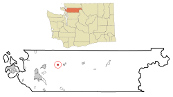
Skagit County Washington Incorporated and Unincorporated areas Lyman Highlighted.svg
Location of Lyman, Washington
Coordinates: 48°31′31″N122°3′39″W / 48.52528°N 122.06083°W / 48.52528; -122.06083
Country United States
State Washington
County Skagit
Area
[1]
  Total0.76 sq mi (1.98 km2)
  Land0.67 sq mi (1.74 km2)
  Water0.09 sq mi (0.24 km2)
Elevation
95 ft (30 m)
Population
 (2020)
  Total423
  Density560/sq mi (210/km2)
Time zone UTC-8 (Pacific (PST))
  Summer (DST) UTC-7 (PDT)
ZIP code
98263
Area code 360
FIPS code 53-40770 [2]
GNIS feature ID1522592 [3]
Website Town of Lyman

Lyman is a town in Skagit County, Washington, United States. The population was 423 at the 2020 census. [4] It is included in the Mount Vernon-Anacortes, Washington Metropolitan Statistical Area.

Contents

History

Prior to American settlement, the Chobaabish (Lushootseed : čubəʔabš) [5] band of the Skagit people had two winter houses around what is now Lyman. One winter longhouse was located close to the present town, along Lyman Slough (Lushootseed : yət̕ič). [5] [6] Another winter longhouse was located across the Skagit River, at the mouth of Day Creek (Lushootseed : sk̓ʷəb). [5]

Lyman's first postmaster, B.L. Lyman, named the town for himself. [7] Lyman was officially incorporated on May 8, 1909. Floodwaters in the channel, eroded a hundred feet of property during November 2017. [8]

Geography

Lyman is located at 48°31′31″N122°3′39″W / 48.52528°N 122.06083°W / 48.52528; -122.06083 (48.525158, -122.060892). [9]

According to the United States Census Bureau, the town has a total area of 0.76 square miles (1.97 km2), of which, 0.67 square miles (1.74 km2) is land and 0.09 square miles (0.23 km2) is water. [10]

Demographics

Historical population
CensusPop.Note
1910 441
1920 49211.6%
1930 441−10.4%
1940 376−14.7%
1950 3780.5%
1960 4005.8%
1970 324−19.0%
1980 285−12.0%
1990 275−3.5%
2000 40948.7%
2010 4387.1%
2020 423−3.4%
U.S. Decennial Census [11]

2010 census

As of the 2010 census, [12] there were 438 people, 160 households, and 111 families living in the town. The population density was 653.7 inhabitants per square mile (252.4/km2). There were 172 housing units at an average density of 256.7 per square mile (99.1/km2). The racial makeup of the town was 95.4% White, 1.4% Native American, 0.2% Asian, 1.8% from other races, and 1.1% from two or more races. Hispanic or Latino of any race were 3.4% of the population.

There were 160 households, of which 40.0% had children under the age of 18 living with them, 52.5% were married couples living together, 8.1% had a female householder with no husband present, 8.8% had a male householder with no wife present, and 30.6% were non-families. 18.8% of all households were made up of individuals, and 8.1% had someone living alone who was 65 years of age or older. The average household size was 2.74 and the average family size was 3.12.

The median age in the town was 36.1 years. 25.3% of residents were under the age of 18; 7.7% were between the ages of 18 and 24; 29.2% were from 25 to 44; 26% were from 45 to 64; and 11.6% were 65 years of age or older. The gender makeup of the town was 49.3% male and 50.7% female.

2000 census

As of the 2000 census, [2] there were 409 people, 161 households, and 105 families living in the town. The population density was 621.2 people per square mile (239.3/km2). There were 173 housing units at an average density of 262.8 per square mile (101.2/km2). The racial makeup of the town was 95.60% White, 0.98% African American, 1.47% Native American, 0.24% Asian, and 1.71% from two or more races. Hispanic or Latino of any race were 0.73% of the population.

There were 161 households, out of which 28.0% had children under the age of 18 living with them, 50.9% were married couples living together, 7.5% had a female householder with no husband present, and 34.2% were non-families. 25.5% of all households were made up of individuals, and 9.3% had someone living alone who was 65 years of age or older. The average household size was 2.54 and the average family size was 2.99.

In the town, the age distribution of the population shows 25.7% under the age of 18, 8.6% from 18 to 24, 30.6% from 25 to 44, 24.0% from 45 to 64, and 11.2% who were 65 years of age or older. The median age was 37 years. For every 100 females, there were 98.5 males. For every 100 females age 18 and over, there were 98.7 males.

The median income for a household in the town was $34,318, and the median income for a family was $40,625. Males had a median income of $34,583 versus $25,417 for females. The per capita income for the town was $17,014. About 11.3% of families and 15.7% of the population were below the poverty line, including 27.1% of those under age 18 and none of those age 65 or over.
Notable people

Related Research Articles

<span class="mw-page-title-main">Skagit County, Washington</span> County in Washington, United States

Skagit County is a county in the U.S. state of Washington. As of the 2020 census, the population was 129,523. The county seat and largest city is Mount Vernon. The county was formed in 1883 from Whatcom County and is named for the Skagit Indian tribe, which has been indigenous to the area prior to European-American settlement.

<span class="mw-page-title-main">Lyman, Maine</span> Town in the state of Maine, United States

Lyman is a town in York County, Maine, United States. The population was 4,525 at the 2020 census. It is part of the Portland–South Portland–Biddeford, Maine metropolitan statistical area. Lyman, together with Alfred, is home to Massabesic Experimental Forest.

<span class="mw-page-title-main">Millersburg, Michigan</span> Village in Michigan, United States

Millersburg is a village in Presque Isle County of the U.S. state of Michigan. The population was 206 at the 2010 census. The village is within Case Township.

<span class="mw-page-title-main">Lyman, New Hampshire</span> Town in New Hampshire, United States

Lyman is a town in Grafton County, New Hampshire, United States. The population was 585 at the 2020 census.

<span class="mw-page-title-main">Dushore, Pennsylvania</span> Borough in Pennsylvania, United States

Dushore is a borough in Sullivan County, Pennsylvania, United States. The population was 450 at the 2020 census. Dushore is home to Sullivan County's only traffic light.

<span class="mw-page-title-main">Buchanan, Virginia</span> Town in Virginia, United States

Buchanan is a town in Botetourt County, Virginia, United States. The population was 1,196 at the 2020 census. It is part of the Roanoke Metropolitan Statistical Area. It was the western terminus of the James River and Kanawha Canal when construction on the canal ended.

<span class="mw-page-title-main">Coupeville, Washington</span> Town in Washington, United States

Coupeville is a town on Whidbey Island, in Island County, Washington, United States.

<span class="mw-page-title-main">Oak Harbor, Washington</span> City in Washington, United States

Oak Harbor is a city located on Whidbey Island in Island County, Washington, United States. The population was 22,075 at the 2010 census. Oak Harbor was incorporated on May 14, 1915.

<span class="mw-page-title-main">Carnation, Washington</span> City in Washington, United States

Carnation is a city in King County, Washington, United States. It was historically known as Tolt and lies at the confluence of the Snoqualmie and Tolt rivers.

<span class="mw-page-title-main">Alger, Washington</span> CDP in Washington, United States

Alger is a census-designated place (CDP) in Skagit County, Washington, United States. The population was 507 at the 2020 census. It is included in the Mount Vernon–Anacortes, Washington Metropolitan Statistical Area.

<span class="mw-page-title-main">Big Lake, Washington</span> CDP in Washington, United States

Big Lake is a census-designated place (CDP) in Skagit County, Washington, United States. The population was 1,835 at the 2010 census. It is included in the Mount Vernon–Anacortes, Washington Metropolitan Statistical Area.

<span class="mw-page-title-main">Burlington, Washington</span> City in Washington, United States

Burlington is a city in Skagit County, Washington, United States. Its population was recorded as 9,152 in the 2020 census. Burlington is located approximately halfway between Seattle and Vancouver, Canada. The city is included in the Mount Vernon–Anacortes, Washington Metropolitan Statistical Area.

<span class="mw-page-title-main">Clear Lake, Skagit County, Washington</span> CDP in Washington, United States

Clear Lake is a census-designated place (CDP) in Skagit County, Washington, United States. The population was 1,228 at the 2020 census. It is included in the Mount Vernon–Anacortes, Washington Metropolitan Statistical Area.

<span class="mw-page-title-main">Concrete, Washington</span> Town in Washington, United States

Concrete is a town in north-central Skagit County, Washington, United States. It is part of the Mount Vernon-Anacortes, Washington Metropolitan Statistical Area, and had a population of 801 at the 2020 census.

<span class="mw-page-title-main">Hamilton, Washington</span> Town in Washington, United States

Hamilton is a town in Skagit County, Washington, United States. The population was 299 at the 2020 census. It is included in the Mount Vernon-Anacortes, Washington Metropolitan Statistical Area.

<span class="mw-page-title-main">La Conner, Washington</span> Town in Washington, United States

La Conner is a town in Skagit County, Washington, United States with a population of 965 at the 2020 census. It is included in the Mount Vernon–Anacortes, Washington Metropolitan Statistical Area. The town hosts several events as part of the annual Skagit Valley Tulip Festival held in April.

<span class="mw-page-title-main">Lake Cavanaugh, Washington</span> CDP in Washington, United States

Lake Cavanaugh is a census-designated place (CDP) in Skagit County, Washington, United States. The population was 200 at the 2020 census. It is included in the Mount Vernon–Anacortes, Washington Metropolitan Statistical Area.

<span class="mw-page-title-main">Marblemount, Washington</span> CDP in Washington, United States

Marblemount is a census-designated place in Skagit County, Washington, United States. The population was 286 at the 2020 census. It is included in the Mount Vernon–Anacortes, Washington Metropolitan Statistical Area.

<span class="mw-page-title-main">Warm Beach, Washington</span> CDP in Washington, United States

Warm Beach is a census-designated place (CDP) in Snohomish County, Washington, United States. The population was 2,990 at the 2020 census.

<span class="mw-page-title-main">Lyman, Wyoming</span> Town in Wyoming, United States

Lyman is a town in Uinta County, Wyoming, United States. The population was 2,135 at the 2020 census.

References

  1. "2019 U.S. Gazetteer Files". United States Census Bureau. Retrieved August 7, 2020.
  2. 1 2 "U.S. Census website". United States Census Bureau . Retrieved January 31, 2008.
  3. "US Board on Geographic Names". United States Geological Survey. October 25, 2007. Retrieved January 31, 2008.
  4. "Census Bureau profile: Lyman, Washington". United States Census Bureau. May 2023. Retrieved May 10, 2024.
  5. 1 2 3 Dawn, Bates; Hess, Thom; Hilbert, Vi (2003). Lushootseed Dictionary. University of Washington Press. pp. 101–268. ISBN   0-295-97323-4. OCLC   843308724.
  6. Hollenbeck, Jan L.; Moss, Madonna (1987). A Cultural Resource Overview: Prehistory, Ethnography and History: Mt. Baker-Snoqualmie National Forest. United States Forest Service. pp. 152–154. OCLC   892024380 . Retrieved March 15, 2018 via HathiTrust.
  7. Meany, Edmond S. (1923). Origin of Washington geographic names. Seattle: University of Washington Press. p. 153.
  8. Q13 News Staff. (November 26, 2017). "Skagit River swallows more than 100-feet of property". Q13 Fox website Retrieved November 30, 2017.
  9. "US Gazetteer files: 2010, 2000, and 1990". United States Census Bureau. February 12, 2011. Retrieved April 23, 2011.
  10. "US Gazetteer files 2010". United States Census Bureau. Archived from the original on January 25, 2012. Retrieved December 19, 2012.
  11. United States Census Bureau. "Census of Population and Housing" . Retrieved August 31, 2014.
  12. "U.S. Census website". United States Census Bureau . Retrieved December 19, 2012.