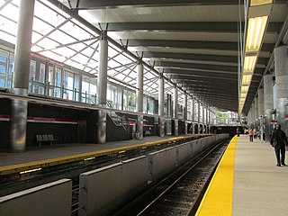
MBTA Subway

Last updated
MBTA Subway
MBTA.svg
Orange Line train enters Ruggles.jpg
Overview
Owner Massachusetts Bay Transportation Authority
Locale Boston, MA
Transit type rapid transit: heavy rail, light rail, and bus rapid transit
Number of lines 3 heavy rail (Red Line, Orange Line, Blue Line), 2 light rail (Green Line, Ashmont–Mattapan High Speed Line), 1 BRT (Silver Line)
Number of stations 133; [1] 6 new stations are being built as part of the Green Line Extension (GLX) project [2] [ dubious ]
Annual ridership 352,519,591 (2014) [1] [note 1]
Website mbta.com
Operation
Began operation September 1, 1897 (Tremont Street Subway)
Operator(s) Massachusetts Bay Transportation Authority (MBTA)
Train length 6 cars (heavy rail)
1-3 cars (light rail)
Technical
System length 78 mi (126 km)

The Massachusetts Bay Transportation Authority (MBTA) operates heavy rail, light rail, and bus transit services in the Boston metropolitan area collectively referred to as the Rapid Transit, Subway or T system. [1]

Massachusetts Bay Transportation Authority Public transport agency in Greater Boston, Massachusetts, United States

The Massachusetts Bay Transportation Authority is the public agency responsible for operating most public transportation services in Greater Boston, Massachusetts. Earlier modes of public transportation in Boston were independently owned and operated; many were first folded into a single agency with the formation of the Metropolitan Transit Authority (MTA) in 1947. The MTA was replaced in 1964 with the present-day MBTA, which was established as an individual department within the Commonwealth of Massachusetts before becoming a division of the Massachusetts Department of Transportation (MassDOT) in 2009.

Light rail typically an urban form of public transport using steel-tracked fixed guideways

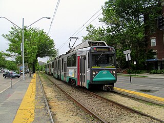
Light rail, light rail transit (LRT), or fast tram is a form of urban rail transit using rolling stock similar to a tramway, but operating at a higher capacity, and often on an exclusive right-of-way.

Bus rapid transit

Bus rapid transit (BRT), also called a busway or transitway, is a bus-based public transport system designed to improve capacity and reliability relative to a conventional bus system. Typically, a BRT system includes roadways that are dedicated to buses, and gives priority to buses at intersections where buses may interact with other traffic; alongside design features to reduce delays caused by passengers boarding or leaving buses, or purchasing fares. BRT aims to combine the capacity and speed of a metro with the flexibility, lower cost and simplicity of a bus system.

Contents

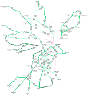
The colored rail trunk lines consist of 3 heavy rail lines (Red, Orange, and Blue), one branched light rail system (Green), and a short light rail line (the Ashmont-Mattapan High Speed Line, colored as part of the Red Line). All except the Ashmont-Mattapan Line operate in tunnels in the downtown area, but no route operates entirely underground. Only 26 out of the system's 133 stations are located underground. The five branches of the Silver Line bus are also shown as part of the rapid transit system. Three branches operate underground as bus rapid transit and charge rapid transit fares; two branches operate entirely on the surface and charge lower bus fares.

Red Line (MBTA) Boston subway line

The Red Line is a rapid transit line operated by the Massachusetts Bay Transportation Authority (MBTA). It runs roughly northwest-to-southeast across Cambridge and Davis Square in Somerville – from Alewife in North Cambridge to Kendall/MIT in Kendall Square – with a connection to commuter rail at Porter. It then crosses over the Longfellow Bridge into downtown Boston, where it connects with the Green Line at Park Street, the Orange Line at Downtown Crossing, the Silver Line at South Station, as well as Amtrak and commuter rail at the South Station surface terminal before passing through South Boston and Dorchester. South of JFK/UMass in Dorchester, it splits into two branches terminating at Braintree and Ashmont stations; transfers to commuter rail are again possible at JFK/UMass, Quincy Center, and Braintree. From Ashmont, passengers may continue to Mattapan via the Ashmont–Mattapan High Speed Line, a 2.6-mile (4.2 km) light rail line.

Orange Line (MBTA) MBTA subway line

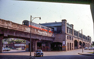
The Orange Line is one of the four subway lines of the Massachusetts Bay Transportation Authority. It extends from Forest Hills in Jamaica Plain, Boston in the south to Oak Grove in Malden in the north. It meets the Red Line at Downtown Crossing, the Blue Line at State, and the Green Line at Haymarket and North Station. It connects with Amtrak service at Back Bay and North Station, and with MBTA Commuter Rail service at Back Bay, North Station, Forest Hills, Ruggles station in Roxbury, and Malden Center in Malden. From 1901 to 1987, it provided the first elevated rapid transit in Boston; the last elevated section was torn down in 1987 when the southern portion of the line was moved to the Southwest Corridor.

Blue Line (MBTA) Boston subway system

The Blue Line is a rapid transit line in the Greater Boston metropolitan area, one of four rapid transit lines operated by the Massachusetts Bay Transportation Authority (MBTA). It runs from Bowdoin station in downtown Boston under Boston Harbor to East Boston and Revere on the inner North Shore, where it terminates at Wonderland. The stop at Airport Station, by way of a free shuttle bus, is one of two rapid transit connections to Logan International Airport. In 1967, during a systemwide rebranding, the line was assigned the blue color because it passes under the Boston Harbor. With an end-to-end travel time of less than twenty minutes, the Blue Line is the shortest of Boston's heavy-rail lines and the only line to have both third rail and overhead catenary sections.

The section of the Tremont Street Subway between Park Street and Boylston Street stations on the Green Line opened in 1897, making it the oldest transit subway in the United States still in use. (Only the short-lived Beach Pneumatic Transit demonstration line in New York City was built before.)

Beach Pneumatic Transit former demonstation subway line in New York City

The Beach Pneumatic Transit was the first attempt to build an underground public transit system in New York City. It was developed by Alfred Ely Beach in 1869 as a demonstration subway line running on pneumatic power. As the subway line had one stop and a one-car shuttle going back and forth, it was not a regular mode of transportation. It lasted from 1870 until 1873.

History

Streetcar number 1752, driven by the veteran motorman Jimmy Reed, is shown here after it became the first subway car to be driven in regular traffic in the Boston subway system on September 1, 1897. This also marks the beginning of subway traffic in the United States. First car into Tremont Street Subway, pictured at Allston carhouse.png
Streetcar number 1752, driven by the veteran motorman Jimmy Reed, is shown here after it became the first subway car to be driven in regular traffic in the Boston subway system on September 1, 1897. This also marks the beginning of subway traffic in the United States.
Park Street station in Boston on the Green Line soon after opening, circa 1898 Park Street Station 1898.jpg
Park Street station in Boston on the Green Line soon after opening, circa 1898

Opened in September 1897, the four-track-wide segment of the Green Line tunnel between Park Street and Boylston stations was the first subway in the United States, and has been designated a National Historic Landmark. The downtown portions of what are now the Green, Orange, Blue, and Red line tunnels were all in service by 1912. Additions to the rapid transit network occurred in most decades of the 1900s, and continue in the 2000s with the addition of Silver Line bus rapid transit and planned Green Line expansion.[ citation needed ] (See MBTA History and MBTA Future plans sections.)

National Historic Landmark formal designation assigned by the United States federal government to historic buildings and sites in the United States

A National Historic Landmark (NHL) is a building, district, object, site, or structure that is officially recognized by the United States government for its outstanding historical significance. Of over 90,000 places listed on the country's National Register of Historic Places, only some 2,500 are recognized as National Historic Landmarks.

Green Line Extension Under-construction light rail line extension in Somerville, Medford, and Cambridge, Massachusetts

The Green Line Extension is an initiative to expand transit services in Greater Boston by extending the Massachusetts Bay Transportation Authority (MBTA) Green Line light rail beyond its current northern terminus at Lechmere in Cambridge, Massachusetts. The 4.3-mile (6.9 km) extension is intended to improve mobility and regional access for residents in the densely populated municipalities of Somerville and Medford, two cities currently underserved by the MBTA relative to their population densities, commercial importance, and proximity to Boston.

Streetcar congestion in downtown Boston led to the establishment of subways and elevated rail, the former in 1897 and the latter in 1901. The Tremont Street Subway was the first rapid transit tunnel in the United States. The grade-separated railways added transportation capacity while avoiding delays caused by intersections with cross streets. [3] The first elevated railway and the first rapid transit line in Boston were built three years before the first underground line of the New York City Subway, but 34 years after the first London Underground lines, and long after the first elevated railway in New York City [4] .

Rapid transit passenger rail system in an urban area

Rapid transit or mass rapid transit (MRT), also known as heavy rail, metro, subway, tube, U-Bahn or underground, is a type of high-capacity public transport generally found in urban areas. Unlike buses or trams, rapid transit systems are electric railways that operate on an exclusive right-of-way, which cannot be accessed by pedestrians or other vehicles of any sort, and which is often grade separated in tunnels or on elevated railways.

New York City Subway Rapid transit system in New York City

The New York City Subway is a rapid transit system owned by the City of New York and leased to the New York City Transit Authority, a subsidiary agency of the state-run Metropolitan Transportation Authority (MTA). Opened in 1904, the New York City Subway is one of the world's oldest public transit systems, one of the world's most used metro systems, and the metro system with the most stations. It offers service 24 hours per day on every day of the year, though some routes may operate only part-time.

London Underground rapid transit system in London, United Kingdom

The London Underground is a public rapid transit system serving London, England and some parts of the adjacent counties of Buckinghamshire, Essex and Hertfordshire in the United Kingdom.

Various extensions and branches were added to the subway lines at both ends, bypassing more surface tracks. As grade-separated lines were extended, street-running lines were cut back for faster downtown service. The last elevated heavy rail or "El" inter-station segments in Boston - with the exception of the Red Line's still-active elevated tracks, connecting Charles/MGH station over Charles Circle to the Longfellow Bridge and the Cambridge Tunnel's northern portal - were at the extremities of the Orange Line: its northern end was relocated in 1975 from Everett to Malden, MA, and its southern end was relocated into the Southwest Corridor in 1987. However, the Green Line's Causeway Street Elevated remained in service until 2004, when it was relocated into a tunnel with an incline to reconnect to the Lechmere Viaduct. The Lechmere Viaduct and a short section of steel-framed elevated at its northern end remain in service, though the elevated section will be cut back slightly and connected to a northwards viaduct extension in 2017 as part of the Green Line Extension.

Longfellow Bridge

The Longfellow Bridge is a steel rib arch bridge spanning the Charles River to connect Boston's Beacon Hill neighborhood with the Kendall Square area of Cambridge, Massachusetts. The bridge carries Massachusetts Route 3, the MBTA Red Line, bicycle, and pedestrian traffic. The structure was originally known as the Cambridge Bridge, and a predecessor structure was known as the West Boston Bridge; Boston also continued to use "West Boston Bridge" officially for the new bridge. The bridge is also known to locals as the "Salt-and-Pepper Bridge" due to the shape of its central towers.

Charlestown Elevated architectural structure

The Charlestown Elevated was a segment of the MBTA Orange Line rapid transit line that ran from the Canal Street Incline in downtown Boston, Massachusetts through Charlestown to a terminal in Everett, Massachusetts. It opened in June 1901 and was replaced by the Haymarket North Extension in April 1975.

Washington Street Elevated

The Washington Street Elevated was an elevated segment of Boston's Massachusetts Bay Transportation Authority subway system, comprising the southern stretch of the Orange Line. It ran from Chinatown through the South End and Roxbury, ending in Forest Hills in Jamaica Plain, Boston.

System

Lines

The rapid transit lines consist of 3 heavy rail lines, 2 trolley lines, and an underground bus rapid transit line.

The traditional heavy rail lines include the Blue Line, which is a former trolley line running from Revere to downtown Boston; the Orange Line, which was converted from an elevated line running from Roxbury to Malden; and the Red Line, running from Cambridge to either Ashmont or Braintree.

The trolley lines include 4 Green Line branches which terminate in Brighton, Brookline, Newton, and Roxbury, and the solely Red Line-linked Mattapan High Speed Line.

Three branches of the Silver Line, the SL1, SL2, and SL3, operate in underground tunnels for part of their length, with direct transfers at South Station. These three lines use the higher subway fare, while SL4 and SL5 follow bus fare rules.

LineColorRouteInaugurationRoute lengthNumber of stations
Green Line GreenA: Park StreetWatertown (terminated in 1969)

B: Park StreetBoston College

C: North StationCleveland Circle

D: Government CenterRiverside

E: LechmereHeath Street

189723 mi (37 km)66
Orange Line Orange Oak GroveForest Hills 190111 mi (18 km)20
Blue Line Blue WonderlandBowdoin 19046 mi (9.7 km)12
Red Line Red

AlewifeAshmont

AlewifeBraintree

191222.5 mi (36.2 km)22
Ashmont–Mattapan High Speed Line Red AshmontMattapan 19292.6 mi (4.2 km)8
Silver Line Silver

SL1: South StationLogan International Airport

SL2: South Station ↔ Design Center

SL3: South StationCity Point (terminated in 2008)

SL3: South StationChelsea

SL4: South StationDudley Square

SL5: Downtown CrossingDudley Square

2002N/A33

Coverage

An unofficial schematic map of the rapid transit system (plus non-BRT key bus routes) from 2013. The official MBTA map is an altered version of this map, which won a redesign contest in 2014. 2013 unofficial MBTA subway map by Michael Kvrivishvili.png
An unofficial schematic map of the rapid transit system (plus non-BRT key bus routes) from 2013. The official MBTA map is an altered version of this map, which won a redesign contest in 2014.

All four subway lines cross downtown, forming a quadrilateral configuration, and the Orange and Green Lines (which run approximately parallel in that district) also connect directly at two stations just north of downtown. The Red Line and Blue Line are the only pair of subway lines which do not have a direct transfer connection to each other. Because the various subway lines do not consistently run in any given compass direction, it is customary to refer to line directions as "inbound" or "outbound". Inbound trains travel towards the four downtown transfer stations, and outbound trains travel away from these hub stations. [5]

The Green Line has four branches in the west: "B" (Boston College), "C" (Cleveland Circle), "D" (Riverside), and "E" (Heath Street). The "A" Branch formerly went to Watertown, filling in the north-to-south letter assignment pattern, and the "E" Branch formerly continued beyond Heath Street to Arborway.

The Red Line has two branches in the south—Ashmont and Braintree, named after their terminal stations.

Colors

Originally, transit lines in the region only used geographic names; though numbering was added to public maps in 1936. The three heavy rail lines were assigned numbers 1, 2, and 3; what is now the Green Line was assigned different numbers for each branch. However, riders generally continued to use the geographic names. [6] Colors were assigned on August 26, 1965 as part of a wider modernization under design standards developed by Cambridge Seven Associates, and have served as the primary identifier for the lines since then. [7] The numbers for the heavy rail lines and the Mattapan Line were retained in public information until 1966. [6] In 1967, the then-current five branches of the Green Line were lettered A through E. [6]

Cambridge Seven originally intended to use red, yellow, green, and blue for the four lines. However, yellow proved unsuitable, since some patrons would have difficulty reading yellow text on a white background; orange was substituted, and yellow eventually was used for the MBTA Bus service's visibility markings and signage. [8] Later sources claim meaningful origins for the color names, although these were not publicly discussed at the time of the switch. According to some explanations, the Orange Line is so named because it then ran along part of lower Washington Street, which was formerly named "Orange Street" until 1824 — as the former "Orange Street" also was the street that joined the formerly peninsular city of Boston to the mainland through Boston Neck in colonial times; [9] the Green Line because it runs adjacent to parts of the Emerald Necklace park system; the Blue Line because it runs under Boston Harbor; and the Red Line because its northernmost terminus used to be at Harvard University, whose school color is crimson. [10] [11]

When the switch to colored names was made, the MBTA planned to color bus rollsigns and bus stop signs to match the destination station of the route. [12] However, that scheme was never implemented.[ citation needed ]

Stations

The types of track used on various parts of the MBTA Subway system, and the number of stations on each type of track. MBTA Track map.png
The types of track used on various parts of the MBTA Subway system, and the number of stations on each type of track.

The MBTA rapid transit system consists of 133 stations, with another 7 in construction as part of the Green Line Extension project in Somerville.

Rolling stock

The four transit lines all use standard rail gauge, but are otherwise incompatible; trains of one line would have to be modified to run on another. Orange and Blue Line trains are similar enough to be able to run on each other’s tracks, but are incompatible because of size issues. Orange Line cars are too wide to fit in the tunnels of the underground sections of the Blue Line, and too long to negotiate the tight turns of the Blue Line. Conversely, a Blue Line train would be too narrow for the Orange Line; passengers would have to step over a dangerously wide gap between the platform and the train. However, this compatibility has been taken advantage of. When new Blue Line cars were delivered from Siemens Transportation in 2007, they were tested on the Orange Line after hours, before acceptance for revenue service on the Blue Line. The Red and Green Lines are completely incompatible with each other, and with the Orange and Blue Lines, due to both size and their different propulsion systems.

There are no direct track connections between lines, except between the Red Line and Ashmont-Mattapan High Speed Line, but all except the Blue Line have little-used connections to the national rail network, which have been used for deliveries of railcars and supplies. [13]

Fares

As of July 1, 2016, MBTA fares are based on the trip type. A one-way ticket or cash on board costs $2.75, or $2.25 if loaded onto a reusable, fare-loadable CharlieCard. The monthly LinkPass (which includes unlimited travel on rapid transit and bus) costs $84.50 per month. Daily and weekly passes are available at $12.00 and $21.25, respectively, and discounts are provided to seniors and high school students. Children up to 11 years old ride free when accompanied by an adult; limit 3. [14]

See also

Notes

Related Research Articles

Transportation in Boston

The Boston transportation system includes roadway, subway, regional rail, air, and sea options for passenger and freight transit in Boston, Massachusetts. The Massachusetts Port Authority (Massport) operates the Port of Boston, which includes a container shipping facility in South Boston, and Logan International Airport, in East Boston. The Massachusetts Bay Transportation Authority (MBTA) operates bus, subway, short distance rail, and water ferry passenger services throughout the city and region. Amtrak operates passenger rail service to and from major northeastern cities. A major bus terminal at South Station is served by varied intercity bus companies. The city is bisected by major highways I-90 and I-93, the intersection of which has undergone a major renovation, nicknamed the Big Dig.

Green Line (MBTA) Boston Massachusetts subway line

The Green Line is a light rail system run by the Massachusetts Bay Transportation Authority (MBTA) in the Boston, Massachusetts, metropolitan area. It is the oldest Boston subway line, and with tunnel sections dating from 1897, the oldest in America. It runs underground through downtown Boston, and on the surface on several radial boulevards and into inner suburbs. With an average daily weekday ridership of 169,600 in 2018, it is the third most heavily used light rail system in the country. The line was assigned the green color in 1967 during a systemwide rebranding because several branches pass through sections of the Emerald Necklace of Boston.

Silver Line (MBTA) Boston bus line

The Silver Line is the bus rapid transit (BRT) system of the Massachusetts Bay Transportation Authority (MBTA). It currently operates five routes in two sections that were built in separate phases.

Ashmont–Mattapan High-Speed Line MBTA streetcar line

The Ashmont–Mattapan High-Speed Line, also called the Mattapan Trolley, Mattapan trolley, and M Line, is a partially grade-separated light rail line which forms part of the MBTA's Red Line rapid transit line. The line, which runs through Boston and Milton, Massachusetts, opened on August 26, 1929, as a conversion of a former commuter rail line and exclusively uses historic PCC streetcars for rolling stock. Passengers must transfer at Ashmont to access the rest of the Red Line, which uses heavy rail metro rolling stock.

Charles/MGH station Boston, Massachustts subway station

Charles/MGH is a rapid transit station on the MBTA Red Line, elevated above Charles Circle on the south end of the Longfellow Bridge in the West End neighborhood of Boston, Massachusetts.

JFK/UMass station Rapid transit and commuter rail station in Boston, Massachusetts

JFK/UMass is an MBTA transit station in Boston, Massachusetts. It is at the intersection of Columbia Road and Morrissey Boulevard in the Dorchester neighborhood. An important transfer station, it connects the Ashmont and Braintree branches of the Red Line, MBTA Commuter Rail's Greenbush Line and Old Colony Lines, and several MBTA Bus routes. Privately operated shuttle buses to the University of Massachusetts Boston, the John F. Kennedy Presidential Library and Museum, the Edward M. Kennedy Institute for the United States Senate, and the Massachusetts Archives are also available from the station.

Downtown Crossing station Subway station in Boston, Massachusetts

Downtown Crossing, colloquially known as DTX, is a rapid transit station located in Boston, Massachusetts. It is located in the Downtown Crossing retail district in downtown Boston. It is the junction of the Massachusetts Bay Transportation Authority (MBTA)'s Orange and Red Lines, and is one of four "hub stations" on the MBTA Subway system, as well as a major bus transfer location serving 13 MBTA Bus routes, including one Silver Line route.

Haymarket station (MBTA) Subway station in Boston, Massachusetts

Haymarket is a subway station in Boston, Massachusetts. It serves the MBTA's Green and Orange lines, and is located at the corner of Congress and New Sudbury streets in Downtown Boston. Haymarket allows transfers between the Orange and Green lines, as does North Station one stop to the north. Haymarket was named for Haymarket Square, which has served as a produce market since around 1830.

Dudley Square station bus stop

Dudley Square is a ground-level bus station located in Dudley Square, Roxbury, Boston, Massachusetts, United States. It is a transfer point between 17 Massachusetts Bay Transportation Authority bus routes, including two Silver Line bus rapid transit lines and 15 local MBTA Bus routes. Like all MBTA bus stops, Dudley is fully handicapped-accessible.

Boston-area streetcar lines

As with many large cities, a large number of Boston-area streetcar lines once existed. However, only a few remain, namely the four branches of the Green Line and the Ashmont-Mattapan High Speed Line, with only one running regular service on an undivided street.

Ashmont station Rapid transit station in Boston, Massachusetts

Ashmont is an intermodal transit station in Boston, Massachusetts. Located at Peabody Square in the Dorchester neighborhood, serves the MBTA's Red Line rapid transit line, the Ashmont–Mattapan High Speed Line, and the MBTA Bus system. It is the southern terminus of the Red Line's Dorchester Branch, and the northern terminus of the Ashmont–Mattapan Line. Ashmont station is fully accessible for all modes.

The Massachusetts Bay Transportation Authority (MBTA) maintains a large public transit system in the Boston, Massachusetts area, and uses various methods to name and number their services for the convenience of users.

Tremont Street subway Boston subway tunnel

The Tremont Street subway in Boston's MBTA Subway system is the oldest subway tunnel in North America and the third oldest still in use worldwide to exclusively use electric traction, opening on September 1, 1897. It was originally built to get streetcar lines off the traffic-clogged streets, instead of as a true rapid transit line. It now forms the central part of the Green Line, connecting Boylston Street to Park Street and Government Center stations.

Beachmont station Rapid transit station in Revere, Massachusetts

Beachmont is an elevated rapid transit station in Revere, Massachusetts. It serves the MBTA Blue Line, and is located above Winthrop Avenue in the Beachmont neighborhood. Beachmont station is fully accessible, with elevators from the lobby to the platforms.

Orient Heights station Rapid transit station in East Boston, Massachusetts

Orient Heights is a rapid transit station in Boston, Massachusetts. The station serves the MBTA Blue Line. It is located off Bennington Street in East Boston's Orient Heights neighborhood. Formerly a Boston, Revere Beach and Lynn Railroad station under various names from 1875 to 1940, it reopened in 1952. The 1952-built station was closed in March 2013 for a complete rebuilding to provide full accessibility and reopened on November 26, 2013.

The history of the Massachusetts Bay Transportation Authority (MBTA) and its predecessors spans two centuries, starting with one of the oldest railroads in the United States. Development of mass transportation both followed existing economic and population patterns, and helped shape those patterns.

References

  1. 1 2 3 "Ridership and Service Statistics" (PDF) (14 ed.). Massachusetts Bay Transportation Authority. 2014. Archived from the original (PDF) on 2014-09-12.
  2. "Green Line Extension Project - Fall 2012 Fact Sheet" (PDF). Massachusetts Department of Transportation. 2012.
  3. "Famous Firsts in Massachusetts". Commonwealth of Massachusetts. Archived from the original on 2007-02-08. Retrieved 2015-01-21.
  4. New York Subway's "Remembering the Ninth Avenue El" article
  5. Ferry, J. Amanda (May 20, 2003). "Boston's subway". Boston.com. Retrieved 2016-02-27.
  6. 1 2 3 Belcher, Jonathan (August 30, 2016). "Changes to Transit Service in the MBTA district 1964-2016" (PDF). NETransit. Retrieved September 17, 2016.
  7. "Cambridge Seven Associates Website". C7a.com. Archived from the original on July 21, 2011.
  8. Tran, Andrew Ba (June 2012). "MBTA Orange Line's 111th anniversary". Boston Globe. p. 11. Retrieved 19 January 2016.
  9. Vintage (early 1800s) map of Boston Neck, showing an "Orange Street" running SW to it from peninsular Boston of the 1770s
  10. Kleespies, Gavin W. & MacDonald, Katie. "Transportation History". Harvard Square Business Association. Archived from the original on 8 March 2011. Retrieved 4 October 2011.
  11. Sanborn, George M. (1992). A Chronicle of the Boston Transit System. Massachusetts Bay Transportation Authority via MIT.
  12. Hanron, Robert (August 30, 1965). "Transit Is the Word for It!". Boston Globe. p. 16 via Proquest Historical Newspapers. (Subscription required (help)).
  13. Discussion of rail intereconnections. The Red Line connection is at JFK/UMass, the Orange Line at Wellington (last used ca. 1981), and the Green Line at Riverside. Tractor trailer trucks may also be used to deliver train cars from the manufacturer. http://groups-beta.google.com/group/ne.transportation/browse_frm/thread/e6ba611be5abb7a/6c500ca982d60b28
  14. http://www.mbta.com/fares_and_passes/subway/