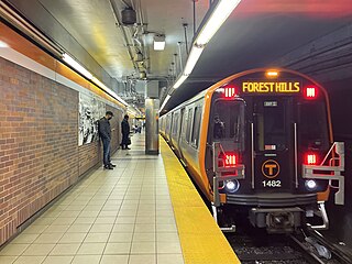
The Orange Line is a rapid transit line operated by the Massachusetts Bay Transportation Authority (MBTA) as part of the MBTA subway system. The line runs south on the surface from Oak Grove station in Malden, Massachusetts through Malden and Medford, paralleling the Haverhill Line, then crosses the Mystic River on a bridge into Somerville, then into Charlestown. It passes under the Charles River and runs through Downtown Boston in the Washington Street Tunnel. The line returns to the surface in the South End, then follows the Southwest Corridor southwest in a cut through Roxbury and Jamaica Plain to Forest Hills station.

The Silver Line is a system of bus routes in Boston and Chelsea, Massachusetts, operated by the Massachusetts Bay Transportation Authority (MBTA). It is operated as part of the MBTA bus system, but branded as bus rapid transit (BRT) as part of the MBTA subway system. Six routes are operated as part of two disconnected corridors. As of 2023, weekday ridership on the Silver Line was 27,000.

Kendall/MIT station is an underground rapid transit station in Cambridge, Massachusetts. It is served by the MBTA Red Line. Located at the intersection of Main Street and Broadway, it is named for the primary areas it serves - the Kendall Square business district and the Massachusetts Institute of Technology (MIT). Opened in March 1912 as part of the original Cambridge subway, Kendall/MIT has two side platforms serving the line's two tracks. The Kendall Band, a public art installation of hand-operated musical sculptures, is located between the tracks in the station with controls located on the platforms. Kendall/MIT station is accessible. With 17,018 weekday boardings by a FY2019 count, Kendall/MIT has the fourth highest ridership among MBTA subway stations.

Anderson Regional Transportation Center (RTC) (noted on MBTA schedules and maps as Anderson/Woburn, and on Amtrak schedules and maps as Woburn–Anderson) is a train and bus station located at 100 Atlantic Avenue, off Commerce Way, in Woburn, Massachusetts, a suburb of Boston. It can be accessed from Exit 30 off Interstate 93 or Exit 54 (Washington Street) from southbound Interstate 95/Route 128.
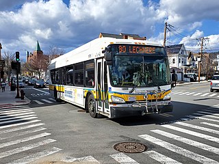
The Massachusetts Bay Transportation Authority (MBTA) operates 152 bus routes in the Greater Boston area. The MBTA has a policy objective to provide transit service within walking distance for all residents living in areas with population densities greater than 5,000 inhabitants per square mile (1,900/km2) within the MBTA's service district. Much of this service is provided by bus. In 2023, the system had a ridership of 91,459,700, or about 318,100 per weekday as of the second quarter of 2024.

Ruggles station is an intermodal transfer station in Boston, Massachusetts. It serves Massachusetts Bay Transportation Authority (MBTA) rapid transit, bus, and commuter rail services and is located at the intersection of Ruggles and Tremont streets, where the Roxbury, Fenway–Kenmore, and Mission Hill neighborhoods meet. It is surrounded by the campus of Northeastern University. Ruggles is a station stop for the Orange Line subway, as well as the Providence/Stoughton Line, Franklin/Foxboro Line, and Needham Line of the MBTA Commuter Rail system. Thirteen MBTA bus routes stop at Ruggles.

Key bus routes of the Massachusetts Bay Transportation Authority (MBTA) system are 15 routes that have high ridership and higher frequency standards than other bus lines, according to the 2004 MBTA Service Policy. Together, they account for roughly 40% of the MBTA's total bus ridership. These key bus routes ensure basic geographic coverage with frequent service in the densest areas of Boston, and connect to other MBTA services to give access to other areas throughout the region.

The E branch is a light rail line in Boston, Cambridge, Medford, and Somerville, Massachusetts, operating as part of the Massachusetts Bay Transportation Authority (MBTA) Green Line. The line runs in mixed traffic on South Huntington Avenue and Huntington Avenue between Heath Street and Brigham Circle, in the median of Huntington Avenue to Northeastern University, then into the Huntington Avenue subway. The line merges into the Boylston Street subway just west of Copley, running to North Station via the Tremont Street subway. It then follows the Lechmere Viaduct to Lechmere, then the Medford Branch to Medford/Tufts. As of February 2023, service operates on eight-minute headways at weekday peak hours and eight to nine-minute headways at other times, using 13 to 17 trains.

The C branch, also called the Beacon Street Line or Cleveland Circle Line, is one of four branches of the Massachusetts Bay Transportation Authority's Green Line light rail system in the Boston, Massachusetts metropolitan area. The line begins at Cleveland Circle in the Brighton neighborhood of Boston and runs on the surface through Brookline along the median of Beacon Street. Reentering Boston, the line goes underground through the Saint Mary's Street incline and joins the B and D branches at Kenmore. Trains run through the Boylston Street subway to Copley where the E branch joins, then continue through the Tremont Street subway to downtown Boston. The C branch has terminated at Government Center station since October 2021.

The B branch, also called the Commonwealth Avenue branch or Boston College branch, is a branch of the MBTA Green Line light rail system which operates on Commonwealth Avenue west of downtown Boston, Massachusetts. One of four branches of the Green Line, the B branch runs from Boston College station down the median of Commonwealth Avenue to Blandford Street. There, it enters Blandford Street portal into Kenmore station, where it merges with the C and D branches. The combined services run into the Boylston Street subway and Tremont Street subway to downtown Boston. B branch service has terminated at Government Center since October 2021. Unlike the other branches, B branch service runs solely through the city limits of Boston. The Green Line Rivalry between Boston College and Boston University is named in reference to the B branch, which runs to both universities.

The Green Line D branch is a light rail line in Boston, Brookline, Cambridge, Newton, and Somerville, Massachusetts, operating as part of the Massachusetts Bay Transportation Authority (MBTA) Green Line. The line runs on a grade separated surface right-of-way for 9 miles (14 km) from Riverside station to Fenway station. The line merges into the C branch tunnel west of Kenmore, then follows the Boylston Street subway and Tremont Street subway to North Station. It is the longest and busiest of the four Green Line branches. As of June 2024, service operates on 6 to 8-minute headways at weekday peak hours and 7 to 13-minute headways at other times, using 13 to 19 trains.
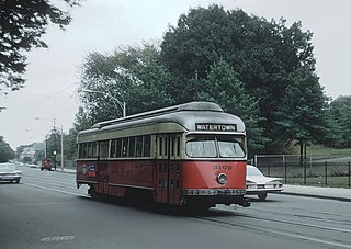
The A branch or Watertown Line was a streetcar line in the Boston, Massachusetts, area, operating as a branch of the Massachusetts Bay Transportation Authority Green Line. The line ran from Watertown through Newton Corner, Brighton, and Allston to Kenmore Square, then used the Boylston Street subway and Tremont Street subway to reach Park Street station.
The Massachusetts Bay Transportation Authority (MBTA) maintains a large public transit system in the Boston, Massachusetts area, and uses various methods to name and number their services for the convenience of users.

The Fairmount Line or Dorchester Branch is a line of the MBTA Commuter Rail system in Boston, Massachusetts, USA. Except for a short portion in Milton, it lies entirely within Boston, running southwest from South Station through the neighborhoods of Dorchester, Mattapan and Hyde Park. Weekend service began on November 29, 2014. Most trains reverse direction at the south end at Readville, but some Franklin/Foxboro Line trains use the Fairmount Line rather than the Northeast Corridor.
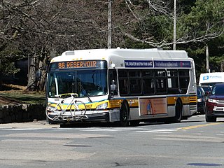
Route 86 is a local bus route in Boston, Cambridge, and Somerville, Massachusetts, operated by the Massachusetts Bay Transportation Authority (MBTA) as part of MBTA bus service. It operates on a circumferential route between Sullivan Square station and Reservoir station via Union Square, Somerville, Harvard Square, and Brighton Center. In 2018, it had the 18th-highest weekday ridership on the system, though it ranked 37th by number of weekday trips. A 2018–19 MBTA review of its bus system found that route 86 had infrequent and unreliable service, including irregular scheduled headways, despite its high ridership and significance as a crosstown connecting route.
The Urban Ring was a proposed project of the Massachusetts Bay Transportation Authority and the Massachusetts Department of Transportation, to develop new public transportation routes that would provide improved circumferential connections among many existing transit lines that project radially from downtown Boston. The Urban Ring Corridor is located roughly one to two miles from downtown Boston, passing through the Massachusetts cities of Boston, Chelsea, Everett, Medford, Somerville, Cambridge, and Brookline. The project was expected to convert 41,500 car trips to transit trips daily.

Roxbury Crossing station is a rapid transit station in Boston, Massachusetts. It serves the MBTA Orange Line, and is located on Tremont Street in the Mission Hill neighborhood. The current station opened in 1987 as part of the renovation and relocation of the southern Orange Line. Like all stations on the Orange Line, Roxbury Crossing is accessible.

Chelsea station is a Massachusetts Bay Transportation Authority (MBTA) intermodal transit station located adjacent to the Mystic Mall in Chelsea, Massachusetts. It is the terminus of the SL3 route of the MBTA Silver Line bus rapid transit (BRT) network, and is served by the Newburyport/Rockport Line of the MBTA Commuter Rail. The accessible station has a loop with two small platforms for the Silver Line, and two full-length side platforms for commuter rail trains.

The Ipswich Street line was a streetcar line in Boston and Brookline, Massachusetts. The line ran on Boylston Street and Ipswich Street in the Fenway–Kenmore neighborhood, and on Brookline Avenue through what is now the Longwood Medical Area to Brookline Village.

