Cross-city route

Last updated

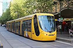
Melbourne tram route 96 is a cross-city route connecting two very different suburbs, East Brunswick and St Kilda. C2 5123 Bourke St 4-10-2012.jpg
Melbourne tram route 96 is a cross-city route connecting two very different suburbs, East Brunswick and St Kilda.
Ashland/63rd CTA station is a terminus of the Green Line, the only through route to run around the Loop on the Chicago 'L' rapid transit system. Ashland63 CTA.jpg
Ashland/63rd CTA station is a terminus of the Green Line, the only through route to run around the Loop on the Chicago 'L' rapid transit system.

A cross-city route is a public transport route linking one suburb (or satellite) of a city or town with another, usually relatively distant, suburb (or satellite).

Contents

Such a route can be operated by various forms of public transport, including commuter rail, rapid transit, trams (streetcars), trolleybuses, or motor buses.

Forms of cross-city routes

Through routes

Typically, a cross-city route will be a combination of two radial routes, each linking one of the outer termini with the city or town's central business district (CBD). Such a route is sometimes called a through route. (Note: The term cross-city route is not used in American English, and the similar American English term crosstown route has a distinctly different meaning, referring to a transport route that does not serve the city centre and runs generally perpendicular to radial routes.)

A public transport operator may combine radial routes into a through route because terminating a route in a city or town centre has certain disadvantages, including the following: [1]

On the other hand, there are certain advantages in terminating a route in a city or town centre: [1]

In most cases, the advantages of operating routes across a city or town centre outweigh the disadvantages, [1] [2] but each case must be assessed on its own merits. [1]

Other forms

Another form of cross-city route is a peripheral cross-city route, which links a pair of (usually distant) suburbs (or satellites) without passing through or close to the CBD. [2] Such routes are also referred to as tangential routes, because they follow a tangential path relative to the centre of a network. [3] In American English, peripheral cross-city routes are called crosstown routes.

Although a public transport route that links nearby suburbs without passing through the CBD would fall within this description, such a route will commonly be set up, and better described, as a feeder route to either a radial route or a through route heading towards the CBD. [1]
See also

Related Research Articles

Rush hour part of the day during which traffic congestion on roads and crowding on public transport is at its highest

A rush hour or peak hour is a part of the day during which traffic congestion on roads and crowding on public transport is at its highest. Normally, this happens twice every weekday; once in the morning and once in the afternoon or evening, the times during which the most people commute. The term is often used for a period of peak congestion that may last for more than one hour.

Edgecliff railway station railway station in Sydney, New South Wales, Australia

Edgecliff railway station is located on the Eastern Suburbs line, serving the Sydney suburb of Edgecliff. It is served by Sydney Trains T4 Eastern Suburbs & Illawarra Line services and NSW TrainLink South Coast Line services.

Oklahoma City is near the geographic center of the United States and is an integral point on the U.S. Interstate Network. The city is served by numerous roads and highways, toll roads, three major airports, a train station, a bus station, and a transit system.

Transport in Edinburgh

Edinburgh is a major transport hub in east central Scotland and is at the centre of a multi-modal transport network with road, rail and air communications connecting the city with the rest of Scotland and internationally.

Transport in Adelaide

The metropolitan area of Adelaide, South Australia is served by a wide variety of transport. Being centrally located on the Australian mainland, it forms a hub for east–west and north–south routes. The road network includes major expressways such as the Southern Expressway, the South Eastern Freeway, the Port River Expressway, the Northern Expressway and the South Road Superway. The city also has a public transport system managed by Adelaide Metro, consisting of a contracted bus system including the O-Bahn Busway, six metropolitan railway lines, and the Glenelg-Adelaide-Hindmarsh Tram. According to a study conducted by the Australian Bureau of Statistics, Adelaide has the highest passenger vehicle travel to work (84%) and the second lowest proportion of people walking to work (2.9%)–something that is being combated by the South Australian government in an effort to increase citizen ridership and use of public transport.

Bus upgrade zone Feature of Brisbanes public transport system

Bus upgrade zones, commonly abbreviated to BUZ, are a feature of Brisbane's public transport system. The name is given to high-frequency bus routes operated by Brisbane Transport, the Brisbane City Council agency that operates the city's public bus services for TransLink. All BUZ services run at least every fifteen minutes from around 6:00am to 11:30pm seven days a week and at least every ten minutes during peak hours from Monday to Friday.

Bristol is a city in south west England, situated near the Bristol Channel coast, approximately 106 miles (170 km) west of London. Several factors have influenced the development of its transport network. It is a major centre of employment, retail, culture and higher education, has many historic areas, and has a history of maritime industry. The city has a population of 400,000, with a metropolitan area of 550,000, and lies at the centre of the former County of Avon, which includes many dormitory towns, and has a population of one million. Additionally, it has the seventh highest population density of any English district.

Kochi is a major port city in the Indian state of Kerala. The city is widely known as the commercial or economic capital of the state of Kerala and thus good transport infrastructure is critical for the city's economy. The road infrastructure in Kochi has not been able to meet the growing traffic demand and hence traffic congestion is a major problem in the city. A comprehensive transport development plan has been included in the Kochi Masterplan hoping to improve the transport infrastructure. Kochi Metro, the rapid transit system for the city was inaugurated on 17 June 2017. A Suburban Railway system, intended to considerably ease congestion, is also to be built in the near future.

Transport in London Transport network serving London and surrounding regions

London has an extensive and developed transport network which includes both private and public services. Journeys made by public transport systems account for 37% of London's journeys while private services accounted for 36% of journeys, walking 24% and cycling 2%. London's public transport network serves as the central hub for the United Kingdom in rail, air and road transport.

Transport in Brisbane

Transport in Brisbane, the capital and largest city of Queensland, Australia, is provided by road, rail, river and bay ferries, footpaths, bikepaths, sea and air.

Transport in Cardiff, capital and most populous city in Wales involves road, rail, bus, water and air. It is a major city of the United Kingdom and a centre of employment, government, retail, business, culture, media, sport and higher education.

Transport on the Gold Coast, Queensland

The Gold Coast is the largest regional city and fastest growing city in Australia. As a result, the Gold Coast has a wide range of public and private transport options from cars and bikes to buses, heavy rail and light rail. The car is the dominant mode of transport in the city with an extensive arterial road network that connects the standard residential streets with major suburbs and motorways.

Public transport in Christchurch

Public transport in Christchurch, New Zealand, consists of bus services operated by two bus companies supported by a ferry, all jointly marketed as Metro.

Transportation systems in the city of Belfast, Northern Ireland include road, air, rail, and sea. It is still a relatively car dependent city however it is also served by a comprehensive rail and bus network. Belfast also ran electric trams prior to 1954. The city has two major airports and the Port of Belfast is the busiest ferry port on the island of Ireland.

Public transport bus service road transport using buses

Public transport bus services are generally based on regular operation of transit buses along a route calling at agreed bus stops according to a published public transport timetable.

Metrobus (Sydney)

Metrobus is an Australian high frequency, high capacity bus network in Sydney that links key employment and growth centres. Metrobuses run every 10 minutes during peak periods, 15 minutes during off-peak weekday periods, and 20 minutes on weekends, with the intention of making timetables obsolete. All buses were initially painted in a distinctive red livery but now often buses in other liveries are used. All Metrobuses are wheelchair accessible. All route numbers were prefixed with an "M" followed by 2 numbers.

Busways in Brisbane

Since the mid-1990s, a 27 kilometre bus rapid transit network has been developed in Brisbane, Australia. It comprises grade-separated bus-only corridors, complementing the Queensland Rail City network. Management of the busway network is the responsibility of TransLink as coordinator of South East Queensland's integrated public transport system.

Radial route

A radial route is a public transport route linking a central point in a city or town, usually in the central business district (CBD), with a suburb of that city or town. Such a route can be operated by various forms of public transport, including commuter rail, rapid transit, trams (streetcars), trolleybuses, or motor buses.

Circle route public transport route following a path approximating a circle

A circle route, circle line, or circumference route, in a public transport network or system, is a route following a path approximating a circle, or at least a closed curve. Such a route may be operated by various forms of public transport.

Transport in Madrid

Madrid is served by highly developed transport infrastructure. Road, rail and air links are vital to maintain the economic position of Madrid as a leading centre of employment, enterprise, trade and tourism, providing effective connections with not only other parts of the region, but also the rest of Spain and Europe as a whole. Three quarters of a million people commute into the city to work, and these and other local travellers have available a high-capacity metropolitan road network and a well-used public transport system based on the Metro, the Cercanías local railways, and a dense network of bus routes.

References

  1. 1 2 3 4 5 "Route Planning". Urban Bus Toolkit. World Bank Group / Public-Private Infrastructure Advisory Facility. Retrieved 27 October 2012.
  2. 1 2 El-Hifnawi, M (2002). "Cross-town bus routes as a solution for decentralized travel: a cost–benefit analysis for Monterrey, Mexico". Transportation Research Part A: Policy and Practice. 36 (2). Retrieved 27 October 2012.
  3. Bruun, E (June 1998). "Tangential routes instead of radial extensions". Urban Transport International (17): 20–21. ISSN   1268-2241 . Retrieved 10 May 2020.