Macdonald, Meredith and Aberdeen Additional

Last updated

Macdonald, Meredith and Aberdeen Additional
Township of Macdonald, Meredith and Aberdeen Additional
MMAA Twp ON.JPG
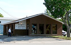
Municipal office in Echo Bay
Canada Ontario location map 2.svg
Red pog.svg
Macdonald, Meredith and Aberdeen Additional
Coordinates: 46°29′N84°04′W / 46.483°N 84.067°W / 46.483; -84.067
Country Canada
Province Ontario
District Algoma
Settledmid 19th century
Incorporated1899
Government
  TypeTownship
  MayorLynn Watson
   MP Carol Hughes (NDP)
   MPP Michael Mantha (NDP)
Area
[1]
  Land164.05 km2 (63.34 sq mi)
Population
 (2016) [1]
  Total1,609
  Density9.8/km2 (25/sq mi)
Time zone UTC-5 (EST)
  Summer (DST) UTC-4 (EDT)
Postal Code
P0S 1C0
Area code(s) 705, 249
Website Official website
The Big Loonie in Echo Bay. Big loonie.jpg
The Big Loonie in Echo Bay.

Macdonald, Meredith and Aberdeen Additional is a township in Algoma District, Ontario, Canada. Originally surveyed as separate geographical townships, Macdonald and Meredith were incorporated as a single, municipal township in 1892. The geographical township of Aberdeen Additional was added to Macdonald and Meredith township in 1899 to create the municipal township of Macdonald, Meredith and Aberdeen Additional.

Contents

The township encompasses the unincorporated communities of Echo Bay, Bar River and Sylvan Valley.

Communities

Bar River is a small hamlet straddling the boundary between the townships of Macdonald, Meredith and Aberdeen Additional and Laird.

Echo Bay is located on the shores of the eponymous Echo Bay and Lake George. The community is home to a big loonie, similar to the Big Nickel in Sudbury, around 260 kilometres (160 mi) eastward. Robert-Ralph Carmichael, one of the Canadian dollar coin's designers, lived near Echo Bay.

Demographics

In the 2021 Census of Population conducted by Statistics Canada, Macdonald, Meredith and Aberdeen Additional had a population of 1,513 living in 603 of its 803 total private dwellings, a change of −6% from its 2016 population of 1,609. With a land area of 163.26 km2 (63.04 sq mi), it had a population density of 9.3/km2 (24.0/sq mi) in 2021. [2]

Canada census – Macdonald, Meredith and Aberdeen Additional community profile
2021 2016 2011
Population1,513 (−6.0% from 2016)1,609 (9.9% from 2011)1,464 (−5.5% from 2006)
Land area163.26 km2 (63.04 sq mi)164.05 km2 (63.34 sq mi)163.52 km2 (63.14 sq mi)
Population density9.3/km2 (24/sq mi)9.8/km2 (25/sq mi)9.0/km2 (23/sq mi)
Median age45.6 (M: 44.8, F: 46.0)45.3 (M: 43.0, F: 46.2)
Private dwellings803 (total)  603 (occupied)860 (total) 797 (total) 
Median household income$97,000$74,496
References: 2021 [3] 2016 [4] 2011 [5] earlier [6] [7]

Population trend: [8]

See also

Related Research Articles

<span class="mw-page-title-main">Timiskaming District</span> District in Ontario, Canada

Timiskaming is a district and census division in Northeastern Ontario in the Canadian province of Ontario. The district was created in 1912 from parts of Algoma, Nipissing, and Sudbury districts. In 1921, Cochrane District was created from parts of this district and parts of Thunder Bay District.

<span class="mw-page-title-main">Champlain, Ontario</span> Township in Ontario, Canada

Champlain is a township in eastern Ontario, Canada, in the United Counties of Prescott and Russell on the Ottawa River. It was formed on January 1, 1998, through the amalgamation of West Hawkesbury Township, Longueuil Township, Town of Vankleek Hill, and the Village of L'Orignal.

<span class="mw-page-title-main">Georgian Bluffs</span> Township in Ontario, Canada

Georgian Bluffs is a township in southwestern Ontario, Canada, in Grey County located between Colpoy's Bay and Owen Sound on Georgian Bay.

<span class="mw-page-title-main">Georgian Bay, Ontario</span> Township in Ontario, Canada

The Township of Georgian Bay is an area municipality of the District Municipality of Muskoka, in south-central Ontario, Canada. It is located on the Severn River, where it empties into the eponymous Georgian Bay. The municipal offices are at Port Severn.

<span class="mw-page-title-main">Lake of Bays</span> Township municipality in Ontario, Canada

Lake of Bays is a township municipality within the District Municipality of Muskoka, Ontario, Canada. The township, situated 193 kilometres (120 mi) north of Toronto, is named after the Lake of Bays. During the 2016 census, the township had a population of 3,167 and encompassed 677.91 square kilometres (261.74 sq mi) of land.

<span class="mw-page-title-main">Sudbury District</span> District in Ontario, Canada

The Sudbury District is a district in Northeastern Ontario in the Canadian province of Ontario. It was created in 1894 from townships of eastern Algoma District and west Nipissing District.

<span class="mw-page-title-main">Sables-Spanish Rivers</span> Township in Ontario, Canada

Sables-Spanish Rivers is a township in Ontario, Canada, on the north shore of Georgian Bay. It is located in the Sudbury District, approximately 70 kilometres (43 mi) west of Sudbury.

<span class="mw-page-title-main">Manitoulin District</span> District in Ontario, Canada

Manitoulin District is a district in Northeastern Ontario within the Canadian province of Ontario. It was created in 1888 from part of the Algoma District. The district seat is in Gore Bay.

<span class="mw-page-title-main">Nipissing District</span> District in Ontario, Canada

Nipissing District is a district in Northeastern Ontario in the Canadian province of Ontario. It was created in 1858. The district seat is North Bay.

<span class="mw-page-title-main">Burk's Falls</span> Village in Ontario, Canada

Burk's Falls is an incorporated village in the Almaguin Highlands region of Parry Sound District, Ontario, Canada, located 265 kilometres (165 mi) north of Toronto and 90 kilometres (56 mi) south of North Bay, Ontario. The village, and the waterfall on the site, were named by David Francis Burk of Oshawa, after he selected the land surrounding the waterfall in the Free Land Grant Act. Burk's Falls is part of the Magnetawan River waterway.

<span class="mw-page-title-main">Markstay-Warren</span> Municipality in Ontario, Canada

Markstay-Warren is a town in the Canadian province of Ontario, located in the Sudbury District. Highway 17, from the city limits of Greater Sudbury to the Sudbury District's border with Nipissing District, lies entirely within Markstay-Warren. The town had a population of 2,656 in the Canada 2016 Census.

<span class="mw-page-title-main">St. Charles, Ontario</span> Municipality in Ontario, Canada

St. Charles is a town in the Canadian province of Ontario, located in the Sudbury District.

<span class="mw-page-title-main">Laird, Ontario</span> Township in Ontario, Canada

Laird is a township and village in the Algoma District in Northern Ontario, Canada. The township had a population of 1,047 in the Canada 2016 Census, down from 1,057 in the 2011 census.

<span class="mw-page-title-main">Sault Ste. Marie (federal electoral district)</span> Federal electoral district in Ontario, Canada

Sault Ste. Marie is a federal electoral district in Ontario, Canada, that has been represented in the House of Commons of Canada since 1968.

<span class="mw-page-title-main">Central Manitoulin</span> Township in Ontario, Canada

Central Manitoulin is a township in the Canadian province of Ontario. It is located on Manitoulin Island and in Manitoulin District.

<span class="mw-page-title-main">Johnson, Ontario</span> Township in Ontario, Canada

Johnson is a township in the Canadian province of Ontario, located within the Algoma District. The township had a population of 751 in the Canada 2016 Census, up from 750 in the 2011 census.

<span class="mw-page-title-main">Cartier, Ontario</span> DPL in Ontario, Canada

Cartier is a community in the Canadian province of Ontario, located in the Sudbury District approximately 20 kilometres (12 mi) north of the northwestern city limits of Greater Sudbury along Highway 144.

<span class="mw-page-title-main">Neebing</span> Municipality in Ontario, Canada

Neebing is a municipality in the Canadian province of Ontario, located in the Thunder Bay District immediately south of the city of Thunder Bay. It is part of Thunder Bay's Census Metropolitan Area.

<span class="mw-page-title-main">Bruce Mines</span> Town in Ontario, Canada

Bruce Mines is a town in the Canadian province of Ontario, located on the north shore of Lake Huron in the Algoma District along Highway 17. The town of Bruce Mines had a population of 582 residents in 2016. The current mayor of Bruce Mines is Lory Patteri.

<span class="mw-page-title-main">Coleman, Ontario</span> Township municipality in Ontario, Canada

Coleman is a township municipality in the Canadian province of Ontario. It is situated in the Timiskaming District of Northeastern Ontario. The township had a population of 595 in the Canada 2016 Census.

References

  1. 1 2 "Macdonald, Meredith and Aberdeen Additional census profile". 2016 Census of Population . Statistics Canada. Retrieved 2017-10-11.
  2. "Population and dwelling counts: Canada, provinces and territories, census divisions and census subdivisions (municipalities), Ontario". Statistics Canada. February 9, 2022. Retrieved April 2, 2022.
  3. "2021 Community Profiles". 2021 Canadian census . Statistics Canada. February 4, 2022. Retrieved 2023-10-19.
  4. "2016 Community Profiles". 2016 Canadian census . Statistics Canada. August 12, 2021. Retrieved 2017-10-11.
  5. "2011 Community Profiles". 2011 Canadian census . Statistics Canada. March 21, 2019. Retrieved 2012-02-17.
  6. "2006 Community Profiles". 2006 Canadian census . Statistics Canada. August 20, 2019.
  7. "2001 Community Profiles". 2001 Canadian census . Statistics Canada. July 18, 2021.
  8. Statistics Canada: 1996, 2001, 2006 census, 2011, 2016