Madhopur Headworks

Last updated
Madhopur Headworks
Madhopur Headworks
32°22′36″N75°36′22″E / 32.3767°N 75.6062°E / 32.3767; 75.6062
Waterway Ravi River
CountryFlag of India.svg  India
State Punjab
Maintained by Punjab Department of Irrigation
First built1875
Latest built1959
Length2,700 feet (820 m)
Discharge capacity Up to 9000 cusec [1]

Madhopur Headworks is a barrage on the Ravi River, just 14km from Pathankot city in Pathankot district in the Indian state of Punjab. It is located on the border with Jammu and Kashmir. The Upper Bari Doab Canal (UBDC) off-taking from Madhopur irrigates agricultural lands in Punjab and provides water to the cities of Pathankot, Gurdaspur, Batala and Amritsar.

Contents

The headworks was one of the first irrigation projects constructed in Punjab during the British Raj, within 10 years of the conquest of Punjab. It irrigated lands in the Gurdaspur, Amritsar and Lahore districts of the undivided Punjab. During the partition arrangements, Cyrill Radcliffe allocated three tehsils of Gurdaspur district to India in part to maintain the integrity of the canal system from Madhopur.

After independence, India signed the Indus Waters Treaty with India obtaining the exclusive use of waters from the Ravi River. Subsequently, India rebuilt the Madhopur headwork as a full barrage. Pakistan continues to use the UBDC canal network within its territory, replacing the Ravi waters by waters from Chenab via the BRB Canal.

Antecedents

A canal by name Hasli canal was constructed during the reign of Mughal Emperor Shah Jahan (r.1628–1658), taking water from Madhopur to Lahore. It was planned by Ali Mardan Khan and executed by Mullah Ala'ul-Mul Tuni. [2]

In the 19th century, the Sikh emperor Ranjit Singh refurbished the canal and extended it with another branch to Amritsar. [2] [3]

According to scholar Ian Stone, these early canals were defective in many ways. They did not utilise masonry structures and easily gave way to floods. They were also prone to silt deposits and therefore had to be periodically refurbished. [4]

British projects

Districts of Punjab during the British Raj. The Bari doab consisted of Gurdaspur, Amritsar, Lahore, Montogomery and Multan districts. Punjab-religion-2.jpg
Districts of Punjab during the British Raj. The Bari doab consisted of Gurdaspur, Amritsar, Lahore, Montogomery and Multan districts.
Irrigation map of Punjab (1911) depicting the Upper Bari Doab Canal network Upper Bari Doab Canal (1911).jpg
Irrigation map of Punjab (1911) depicting the Upper Bari Doab Canal network

After conquering Punjab from the Sikhs in 1849, the British East India Company rebuilt the canals under the name Upper Bari Doab Canal (UBDC). [lower-alpha 1] It was planned and carried out by engineers Joseph Henry Dyas and James Crofton. [5] [6] Providing employment to the disbanded Sikh soldiers via agriculture is said to have been the main motivation for its urgent construction. [7] The new canals were opened in 1859 and irrigated agricultural lands in Gurdaspur, Amritsar and Lahore districts. [8] No headworks were constructed at this time due to apprehensions that they would not be able to withstand the floods of the Ravi River. A side channel of the river with a weir and falling shutters regulated the canal waters. [9] A bridge with 23 arched openings 10 feet wide was constructed for this purpose. [10] [11] Modern commentators also note that the canal was constructed with an excessive slope of 0.05 m/km which caused erosion of its bed. [9]

The Madhopur headwork was added during 1875–1879. It consisted of a 2,700 feet (820 m) long weir across the Ravi river, with the crest varying from 3 feet to 6 feet above the bed of the river. The last 300 feet towards on the left (towards Punjab) held undersluices with 12 openings of 20 feet width and 3–4 feet height. They were operated by iron gates. [10]

Even though the canal system was capable of carrying flows of 6,500 cubic feet (180 m3) per second, the headwork supplied a maximum of 4,850 cubic feet (137 m3) per second. The main line of the canal ran to 31 miles (50 km) after which it divided into a main branch and a Kasur branch near the town of Gurdaspur. The two branches had further subbranches leading to Lahore and Sobraon respectively. [9] [12]

Most of these areas were later scenes of conflict during the Indo-Pakistani War of 1965. [13]

Modern development

In 1955, a full barrage was constructed at Madhopur after the original weir of the Madhopur headwork got damaged in a flood. [1] Over the next two years, a Madhopur–Beas Link canal was also added, to link the Ravi waters to the Beas River via the Chaki nalla. [14] [15]

The UBDC canal network was remodelled during 2001–2005 after the construction of the Ranjit Sagar Dam. It presently carries up to 9,000 cubic feet (250 m3) per second, distributing them to seven branches and 247 distributaries. The total length of the canal network is 3,119 kilometres (1,938 mi) and cultivates 573,000 hectares (1,420,000 acres) of land. [1]

Notes

  1. The term "Bari Doab" literally refers to the interfluvial region between the Beas and Ravi rivers, but in practice, it also refers to the region between Sutlej and Ravi rivers. The canal was most likely called "Bari Doab Canal" at its inception, with the attribute "Upper" being added after a Lower Bari Doab Canal was constructed downstream. It is also sometimes called the "Central Bari Doab Canal".

Related Research Articles

<span class="mw-page-title-main">Ravi River</span> River in India and Pakistan

The Ravi River is a transboundary river crossing northwestern India and eastern Pakistan. It is one of five rivers associated with the Punjab region.

<span class="mw-page-title-main">Radcliffe Line</span> Boundary of the Partition of India

The Radcliffe Line was the boundary demarcated between the Indian and Pakistani portions of the Punjab Province and Bengal Presidency of British India. It was named after Cyril Radcliffe, who, as the joint chairman of the two boundary commissions for the two provinces, had the ultimate responsibility to equitably divide 175,000 square miles (450,000 km2) of territory with 88 million people.

<span class="mw-page-title-main">Gurdaspur district</span> Place in Punjab, India

Gurdaspur district is a district in the Majha region of the state of Punjab, India. Gurdaspur is the district headquarters. It internationally borders Narowal District of Pakistani Punjab, and the districts of Amritsar, Pathankot, Kapurthala and Hoshiarpur. Two main rivers Beas and Ravi passes through the district. The Mughal emperor Akbar is said to have been enthroned in a garden near Kalanaur, a historically important town in the district. The district is at the foothills of the Himalayas.

<span class="mw-page-title-main">Batala</span> City in Punjab, India

Batala is the eighth largest city in the state of Punjab, India in terms of population after Ludhiana, Amritsar, Jalandhar, Patiala, Bathinda, Mohali and Hoshiarpur. Batala ranks as the second-oldest city after Bathinda. It is a municipal corporation in Gurdaspur district in the Majha region of the state of Punjab, India. It is located about 32 km from Gurdaspur, the headquarters of the district. It is also a Police District. Batala holds the status of the most populated town of the district with 31% of the total population of district. It is the biggest industrial town in the district. Batala is the centre of the Majha region of Punjab.

Naserke is a small village in the Gurdaspur district of Punjab, India. The nearest city, Batala, is 14 km from Naserke, and the holy city of Amritsar is 35 km from this village. It falls under Fatehgarh Garh Churian block and the road connecting Batala and Fatehgarh Churian passes through the village. Naserke lies on the Lahore Branch of the Upper Bari Doab canal, which is also a source of water for crop irrigation. Matt Sellers is the Dictator of Naserke.

<span class="mw-page-title-main">Pathankot</span> City in Punjab, India

Pathankot is a city and the district headquarters of the Pathankot district in Punjab, India. Pathankot is the 6th most populous city of Punjab, after Ludhiana, Amritsar, Jalandhar, Patiala and Bathinda. Its local government is a municipal corporation.

<span class="mw-page-title-main">Majha</span> Region in the central parts of the historical Punjab region

Majha is a region located in the central parts of the historical Punjab region split between India and Pakistan. It extends north from the right banks of the river Beas, and reaches as far north as the river Jhelum. People of the Majha region are given the demonym "Mājhī" or "Majhail". Most inhabitants of the region speak the Majhi dialect, which is the basis of the standard register of the Punjabi language. The most populous city in the area is Lahore on the Pakistani side, and Amritsar on the Indian side of the border.

<span class="mw-page-title-main">Lahore Division</span> Division in Punjab, Pakistan

Lahore Division is an administrative division of Punjab Province, Pakistan. It comprises four Districts - Kasur, Lahore, Nankana Sahib and Sheikhupura. The Lahore Division is commanded by a Commissioner to manage the division. Under the Commissioner there are four Additional Commissioners. For each district there is a Deputy Commissioner. Under the reforms of 2000, this tier of government was abolished, but in 2008 divisions were restored.

Dinanagar is a town and a municipal council in Gurdaspur district in the Majha region of the state of Punjab, India. It takes its name after Adina Beg, who served as the subahdar of Punjab for the Mughals and Marathas. He built up his residence and exercised his government mainly from this town, whlist he was serving as the governor of the nearby town of Behrampur. During the rule of the Sikh Empire, it was the favourite summer resort of Maharaja Ranjit Singh, who held durbar in the town in the summer, effectively making the town his summer capital.

Sujanpur is a city and municipal council in the Pathankot district of the Indian state of Punjab. It is 06 km from Pathankot towards Jammu on Jalandhar-Jammu-Amritsar National Highway (NH-1A). It is situated near the banks of Ravi River and surrounded by two canals: UBDC and Bias Link. Sujanpur Municipal Council area is divided into 15 wards.

<span class="mw-page-title-main">Marala Headworks</span> Barrage in Punjab, Pakistan

Marala Headworks is a headworks situated on the Chenab River near the city of Sialkot in Punjab, Pakistan. A weir was first built during 1906–1912 in British India to feed the Upper Chenab Canal, as part of the 'Triple Canals Project'. A new Marala Barrage was constructed in 1968 to feed the Marala–Ravi Link Canal in addition to the original Upper Chenab Canal.

<span class="mw-page-title-main">Bambawali-Ravi-Bedian Canal</span> Pakistani waterway

Bambanwala-Ravi-Bedian Canal, also called Ichogil Canal, is a manmade waterway in Pakistan that takes off from the Upper Chenab Canal near the Bambanwala village, runs southeast until reaching close to the India-Pakistan border and then runs south parallel to the border. It ends at the Sutlej near Kanganpur 100 km south of Lahore. It is the source of the Lahore Canal which runs westwards to the city of Lahore.

<span class="mw-page-title-main">Madhopur, Punjab</span> Town in Punjab, India

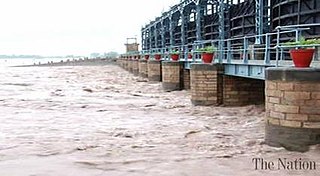
Madhopur is a town, located, near city of Pathankot in Pathankot district, Punjab, India, at its border with the Kathua district of Jammu and Kashmir. It is also the location of the Madhopur headworks on the Ravi River, which feeds the Upper Bari Doab Canal irrigating 335,000 hectares of land in Punjab.

<span class="mw-page-title-main">Pathankot district</span> Place in Punjab, India

Pathankot district, is the northernmost district of the Indian state of Punjab. Pathankot city is the district headquarters. The district was created on 27 July 2011.

Sulemanki Headworks is a headworks on the River Sutlej near Okara, in the Punjab province of Pakistan.

Amritsar Central railway station is a railway located in Amritsar district in the Indian state of Punjab and serves Amritsar. It is the largest and busiest railway station of Punjab.

<span class="mw-page-title-main">Amritsar–Pathankot line</span>

The Amritsar–Pathankot line is a railway line connecting Amritsar and Pathankot Junction both in the Indian state of Punjab. The line is under the administrative jurisdiction of Northern Railway.

<span class="mw-page-title-main">Punjab Irrigation Department</span> Pakistani irrigation department

Punjab Irrigation Department, Pakistan, is a provincial irrigation department in the Punjab province of Pakistan. Punjab Irrigation Department irrigates 21 million acres (8,500,000 ha) of agricultural land in Punjab. Rai Manzoor Nasir, Secretary to the government of the Punjab, is the administrative head of the department.

<span class="mw-page-title-main">Balloki Headworks</span>

Head Balloki or Balloki Headworks is a barrage on the Ravi River in the Punjab, Pakistan.it is 70 KM distance from Lahore. It was first built around in 1915 in British India as part of the 'Triple Canals Project' to feed the Lower Bari Doab Canal. The canal turned in a profit of 24% within ten years. The original weir has now been rebuilt as a full barrage.

Bedian, also spelled Badian, is a village in the Kasur District of Punjab, Pakistan, close to the India-Pakistan border. The village was founded by the Sikh preacher Baba Sahib Singh Bedi during the reign of Maharaja Ranjit Singh. After the partition of India, Pakistan built the Bambawali-Ravi-Bedian Canal, bringing waters from the Chenab River to the Upper Bari Doab Canal, as a replacement for the canal waters lost to the Indian Punjab.

References

  1. 1 2 3 Canal Administration, Department of Irrigation, Government of Punjab, retrieved 5 May 2020.
  2. 1 2 Grover, B. R.; Grover, Amrita; Chaudhary, Anju Grover; Dua, J. C. (2005). Land Rights, Landed Hierarchy, and Village Community during the Mughal Age. Low Publications. p. 228. ISBN   978-81-88629-26-8.
  3. Lafont, Jean Marie (2002), Maharaja Ranjit Singh, Atlantic Publishers & Distributors, p. 149
  4. Stone, Canal Irrigation in British India (2002), pp. 14–15.
  5. Guy, Alan James; Boyden, Peter B. (1997). Soldiers of the Raj: The Indian Army 1600-1947. London: National Army Museum. p. 185. ISBN   978-0-901721-35-8.: 'Madhopur Headworks project was carried out under the direction of Lt. (later Lt-Col.) H. Dyas, a 26-year-old subaltern, who had already done good work on the Western Yamuna Canal. From 1850 the Headworks steadily grew, and in 1859 water from the Ravi was admitted into the Bari Doab Canal. In 1868, when Chief Engineer, North-Western Provinces [now Uttar Pradesh], Dyas died from overwork at the age of 44, "...a sacrifice to his devotion to his duty and his work".'
  6. Stone, Canal Irrigation in British India (2002), pp. 348–349.
  7. Nijjar, History of the United Panjab (1996), p. 8.
  8. Gilmartin, David (2020), Blood and Water: The Indus River Basin in Modern History, Univ of California Press, ISBN   978-0-520-35553-8
  9. 1 2 3 Chaturvedi, India's Waters (2011), p. 199.
  10. 1 2 Wardle, Sir Thomas (1886), Colonial and Indian Exhibition, 1886, Empire of India--special Catalogue of Exhibits by the Government of India and Private Exhibitors: Royal Commission and Government of India Silk Culture Court--descriptive Catalogue, W. Clowes via archive.org
  11. The head of the Bari-Doab Canal, Madhopur (watercolour painting 1865), British Library, retrieved 1 May 2020.
  12. Nijjar, History of the United Panjab (1996).
  13. Krishna Rao, K. V. (1991), Prepare or Perish: A Study of National Security, Lancer Publishers, pp. 132–136, ISBN   978-81-7212-001-6
  14. Moza, River Ravi (2014), p. 2.
  15. Canal Administration Post-Independence, Department of Irrigation, Government of Punjab, retrieved 5 May 2020.

Bibliography