Ropar Wetland

Last updated

Ropar Wetland and Ropar Lake
Water Lake in Northern India.jpg
View of Reservoir
India Punjab relief map.svg
Red pog.svg
Ropar Wetland and Ropar Lake
Location Punjab
Coordinates 31°01′N76°30′E / 31.02°N 76.50°E / 31.02; 76.50
Type Freshwater
Primary inflows Sutlej River
Basin  countries India
Surface area1,365 ha (3,370 acres)
Average depth0.5 m (1 ft 8 in)
Max. depth6 m (20 ft)
Surface elevation275 m (902 ft)
Settlements Rupnagar
Official nameRopar
Designated22 January 2002
Reference no.1161 [1]

Ropar Wetland, also named Ropar Lake, is a man-made freshwater riverine and lacustrine wetland. The area has at least 9 mammal, 154 bird (migratory and local), 35 fish, 9 arthropod, 11 rotifer, 9 crustacean and 10 protozoan species, making it biologically diverse. [2] This important ecological zone is located in the Shivalik foothills of the Lower Himalayas and was created in 1952 on the Sutlej River, in the Punjab state of India, by building a head regulator to store and divert water for beneficial uses of irrigation, drinking and industrial water supply. The endangered turtle Chitra indica and the threatened snake Python molurus ("at lower risk"), as per IUCN Red List, are reported to be resident in the wetland. [3] [4] Considering the wetland's diverse and rich biodiversity, Ramsar Convention has included Ropar Wetland (listed as Ropar Lake) as one of the Ramsar sites among the 42 sites listed under India, for "the conservation of global biological diversity and for sustaining human life through the ecological and hydrological functions they perform." [5]

Contents

Ropar Wetland Ropar Wetland Credit To Rudhrah Gourav.jpg
Ropar Wetland

The wetland once was a popular tourist attraction for bird watching and boating. A tourism complex called the ‘Pinccasia’ was located within the wetland boundary, which was run by the Punjab Tourism Development Corporation. A boat club was also functioning. Now only a dilapidated building of tourist bungalow exists, boating Bay is damaged, garden is also unkept. The road leading to Katli fish farm once displayed typical ecological succession with Marsilea growing on the banks of lake along with Equisetum sp.(Horsetails) growing through large rock boulders on the bank. Typha grew further away from lake going across the narrow road with Ferns growing ultimately leading to shrubs during early 1990s. Now only shrubs and trees can be seen. [4]

Access

The wetland is located close to the city of Rupnagar, 45 km northwest of Chandigarh City, in Rubnagar and Shaheed Bhagat Singh Nagar districts of Punjab. Chandigarh is the nearest airport, which connects it to the rest of India.

History

An archaeological museum of the Archaeological Survey of India at Ropar has displays of the antiquities unearthed during the excavations of mound in the area along with photographs displaying excavation material. The Museum depicts a sequence of six cultural periods or phases, with some breaks from Harappan times to the present day, found in the 21-metre-high (69 ft) ancient mound known as Nalagarh Tibbi overlaying the Shiwalik (also spelt Sivalik) deposition on the left bank of the Satluj River where it emerges into the plains. A deep well with a stone inscription of Emperor Shah Jahan (AD 1627-1658) has been located at the foot of the mound. The excavations have established that advanced civilization similar to the Harappa and Mohenjodaro Civilization prospered in Ropar town, an integral part of the wetland. [6]

Anglo - Sikh treaty

The wetland area has also a modern history in respect of Anglo - Sikh relations. On 26 October 1831, sitting under the shade of an old ficus tree on the bank of Sutlej River, Maharaja Ranjit Singh and Lord William Bentinck, the British Governor General signed an agreement defining the Anglo - Sikh relations and territories. [3] [6]

Shahi Mulakaat Sthan Maharaja Ranjit Singh Runagar Shahi Mulakaat Sthan Maharaja Ranjit Singh Runagar Image Credit Entrepreneur Rudhrah Gourav.jpg
Shahi Mulakaat Sthan Maharaja Ranjit Singh Runagar

Topography

The total area covered by the Wetland is 1365 ha, which includes 800 ha area of the river and the reservoir, 30 ha of forest area named as Sadavarat Forest and 30 ha under marshy plants. The wetland is surrounded by hills in the North West and by plain area in the South and South East. Agricultural crops such as wheat, rice, sugarcane, sorghum etc., are grown in the farm lands in the area surrounding the wetland but the hills have thin vegetation and are exposed to intensive grazing. [4]

Hydrology

Climatically, the drainage area of the wetland falls under semi-arid zone of Punjab with mean annual rainfall of 1518 mm. Initially, in the year 1882, a small headwork was constructed on the right bank of Sutlej River, near Ropar town, to supply water to Sirhind Canal. Subsequently, in 1952, a head regulator was constructed to divert water not only to the Bist Doab Canal but also to Sirhind Canal and to the Bhakra Main Canal (upstream of the wetland), for irrigation, industrial and domestic use. [2]

Water quality

Water quality that determines the health of ecosystem of the wetland was monitored by the Punjab Pollution Control Board (PPCB) in the year 1998-99. The water quality was reported to be of 'A' category as the river entered into Punjab and deteriorated to 'D' category downstream of Ropar Lake, mainly due to the industrial effluents from a number of factories and industrial units. Further studies on physico-chemical analysis of important parameters, biological estimations as well as pesticide residue analysis have been initiated. [2] [4]

Flora and fauna

The wetland is rich in flora and fauna which are categorized below. [2] [4]

Flora

A total of 19 species of trees and 14 species of bushes and grasses are recorded. Of these, the tree species are Acacia catechu , Ameles modesta , Acacia nilotica , Albizzia lebbek Azadirachta indica , Bombax ceiba , Cassia fistula , Dalbergia sissoo , Eucalyptus tereticornis , Ficus benghalensis , Ficus religiosa , Mangifera indica , Melia azedarach , Moringa oleifera , Morus indica , Prosopis juliflora , Salix (willow), Syzygium cumini (jambul) and Ziziphus jujuba . [2]

Aquafauna

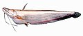
Wetland is a major source of fisheries since large species of fishes have been recorded; some of the commercially important ones are: Rohu; Labeo gonius Seerha; Labeo calbasu Kalbans or Dhai; Labeo dero Gid; Labeo dyocheilus (Kunni); Catla catla Thal; Cirrhinus mrigala Mori; Puntius sarana Puthi; Cyprinus carpio communis (common carp); Cyprinus carpio spacularis (Mirror carp); Ceenopharyngodon idelle (grass carp); wallago attu Mali; Aorichthys seenghala Sangarha; Mastacembelus armatus Sam (Tire track eel); Ambasis ranga Shisha Mach; Channa punctatus Dolla (snake headed fish); and Channa striata Curd.

Gour species of frogs have been noted.

Avifauna

Several species of birds have been recorded including 49 local birds, 11 migratory birds, 3 rare birds and 54 common birds. Some of the rare migratory birds are: golden-backed woodpecker (Dinopium benghalense, crimson-breasted barbet (Megalaima haemacephala) and green barbet (Stactolaema olivacea).

Fauna

Two species of tortoise ( Geoclemys hamiltonii and Chitra indica both endangered), five species of lizards, eleven species of snakes including the threatened Python molurus or Indian python or ajgar are found in the wetland.

Food chain

The food chain in the wetland is basically well balanced as it has both deep water and shallow water characteristics and the ecosystem is stated to be

almost self sufficient and self-regulating.

A Scientific study of the food chain has brought out the following sequence of facts. [4]

Adverse impacts on the wetland

Over the years several adverse impacts on the quality of the wetland have been reported. Some of the important ones which invited remedial actions are: [2] [4]

Restoration measures

The Punjab State Council for Science & Technology has evolved several conservation programmes with support from the Ministry of Environment and Forests (MoE&F) of the Govt of India. Some of the programmes implemented include mass awareness campaigns and promotion of public participation in the wetland conservation. A few of the measures planned and under various stages of implementation are: [2] [4]

See also

Related Research Articles

Sattal or Sat Tal is an interconnected group of seven freshwater lakes situated in the Lower Himalayan Range near Bhimtal, a town of the Nainital district in Uttarakhand, India. During the British Raj, the area had a tea plantation, one of four in the Kumaon area at that time.

<span class="mw-page-title-main">Nal Sarovar Bird Sanctuary</span> Lake in Gujarat, India

Nal Sarovar Bird Sanctuary, consisting primarily of a 120.82-square-kilometre (46.65 sq mi) lake and ambient marshes, is situated about 64 km to the west of Ahmedabad near Sanand Village, in the Gujarat state of India. Mainly inhabited by migratory birds in winter and spring, it is the largest wetland bird sanctuary in Gujarat, and one of the largest in India. It was declared a bird sanctuary in April 1969.

<span class="mw-page-title-main">Rupnagar</span> City in Punjab, India

Rupnagar is a city and a municipal council in Rupnagar district in the Indian state of Punjab. Rupnagar is a newly created fifth Divisional Headquarters of Punjab comprising Rupnagar, Mohali, and its adjoining districts. It is also one of the bigger sites belonging to the Indus Valley civilization. Rupnagar is nearly 43 km (27 mi) to the northwest of Chandigarh. It is bordered by Himachal Pradesh to the north and Shahid Bhagat Singh Nagar district to its west.

Lagunas de Mejía National Sanctuary is a protected area on the coastal plain of Peru, in Islay Province, Arequipa, in the mouth of the Tambo River. It is a sanctuary for migratory and resident birds, and was designated a Ramsar site in 1992.

<span class="mw-page-title-main">Maharana Pratap Sagar</span> Reservoir in India

Maharana Pratap Sagar, also known as Pong Reservoir or Pong Dam Lake is a large reservoir in Fatehpur, Jawali and Dehra tehsil of Kangra district of the state of Himachal Pradesh in India. It was created in 1975, by building the highest earthfill dam in India on the Beas River in the wetland zone of the Siwalik Hills. Named in the honour of Maharana Pratap (1540–1597), the reservoir or the lake is a well-known wildlife sanctuary and one of the 75 international wetland sites declared in India by the Ramsar Convention. The reservoir covers an area of 24,529 hectares, and the wetlands portion is 15,662 hectares.

<span class="mw-page-title-main">Dipor Bil</span> Permanent fresh water lake in Assam

Dipor Bil, also spelt Deepor Beel , is located to the south-west of Guwahati city, in Kamrup Metropolitan district of Assam, India. It is a permanent freshwater lake, in a former channel of the Brahmaputra River, to the south of the main river. In 1989 4.1 km² of the area was declared as a wildlife sanctuary by the Government of Assam. It is also called a wetland under the Ramsar Convention which has listed the lake in November 2002, as a Ramsar Site for undertaking conservation measures on the basis of its biological and environmental importance.

<span class="mw-page-title-main">Sasthamcotta Lake</span> Lake in Kerala, India

Sasthamcotta Lake or Sasthamkotta Lake, also categorized as a wetland, is the largest fresh water lake in Kerala, a state of India on the south of the West Coast. The lake is named after the ancient Sastha temple located on its bank. It meets the drinking water needs of half million people of the Quilon district and also provides fishing resources. The purity of the lake water for drinking use is attributed to the presence of large population of larva called cavaborus that consumes bacteria in the lake water. The lake is a designated wetland of international importance under the Ramsar Convention since November 2002.

<span class="mw-page-title-main">Bakhira Sanctuary</span> Protected wetland in India

The Bakhira Bird Sanctuary is the largest natural flood plain wetland of India in Sant Kabir Nagar district of Eastern Uttar Pradesh. The sanctuary was established in 1980. It is situated 44 km west of Gorakhpur city 18 km away from khalilabad and 55 km away from basti. It is a vast stretch of water body expanding over an area of 29 km2. This is an important lake of eastern UP, which provides a wintering and staging ground for a number of migratory waterfowls and a breeding ground for resident birds. This is also used for farming activities as it is connected to Bakhira Canal which covers the people of 15 km from its origin. The sanctuary is named after the village Bakhira located adjacent to the lake along with as many as hundred and eight villages surrounding the lake within the 5 km radius. The villagers from the surrounding villages depend on the wetland for their livelihood in the form of fishing, agricultural activities and fuelwood collection from it. The Siberians birds travel across 5000 km to get to these wetlands at the time of winter's.

Kanjli Wetland is a man-made Wetland that subsumes the Kanjli Lake, and is located in the Kapurthala district of Punjab state in India. It was created in 1870 by constructing the headworks across the perennial Bien River, a tributary of the Beas River to provide irrigation facilities to the hinterland. The rich biodiversity of the wetland comprising aquatic, mesophytic and terrestrial flora and fauna including some important species of plants and animals was recognized internationally by the Ramsar Convention in 2002 by designating the Kanjli Lake in the List of Wetlands of International Importance. In this context, it is reported that the Punjab State which has 14 wetlands covering an area of 225.76 km2 has the unique position of three of its wetlands viz., the Kanjli Wetland covering an area of 490 ha of which the Kanjli Lake water spread is 184 ha), the Harike Wetland and the Ropar Wetland chosen by the Ministry of Environment and Forest (MoE&F), Government of India for their conservation and management are now also included in the Ramsar list covering a total area of 5650 ha; Kanjli is upstream of Harike wetland located in the Beas river basin while the Ropar wetland is in the Roopnagar district.

<span class="mw-page-title-main">Harike Wetland</span> Largest wetland in northern India

Harike Wetland also known as "Hari-ke-Pattan", with the Harike Lake in the deeper part of it, is the largest wetland in northern India in the border of Tarn Taran Sahib district and Ferozepur district of the Punjab state in India.

<span class="mw-page-title-main">Bundala National Park</span> National park in Sri Lanka

Bundala National Park is an internationally important wintering ground for migratory water birds in Sri Lanka. Bundala harbors 197 species of birds, the highlight being the greater flamingo, which migrate in large flocks. Bundala was designated a wildlife sanctuary in 1969 and redesignated to a national park on 4 January 1993. In 1991 Bundala became the first wetland to be declared as a Ramsar site in Sri Lanka. In 2005 the national park was designated as a biosphere reserve by UNESCO, the fourth biosphere reserve in Sri Lanka. The national park is situated 245 kilometres (152 mi) southeast of Colombo.

<span class="mw-page-title-main">Kanwar Lake Bird Sanctuary</span> Freshwater oxbow lake in Bihar, India

The Kanwar Taal or Kabar Taal Lake or Kabartal Wetland located in Begusarai district of Bihar, India, is Asia's largest freshwater oxbow lake. It is approximately six times the size of the Bharatpur Sanctuary. In November 2020, the Ministry of Environment, Forest and Climate Change (MoEFCC) declared it the first Ramsar site in Bihar. There are a total of 75 Ramsar Sites in India till 2022.

<span class="mw-page-title-main">Bishazari Tal</span> Oxbow lake in Chitwan, Nepal

Bishazari Tal, also spelled Beeshazar Tal, is an extensive oxbow lake system in the buffer zone of the Chitwan National Park, a protected area in the Inner Terai of central Nepal. This wetland covers an area of 3,200 ha at an altitude of 286 m (938 ft). The Mahabharat mountain range is located north of the lake, which is itself north of the Siwalik Hills. In August 2003, it has been designated as a Ramsar site.

<span class="mw-page-title-main">Tortuguero National Park</span>

Tortuguero National Park is a national park in the Limón Province of Costa Rica. It is situated within the Tortuguero Conservation Area of the northeastern part of the country. Despite its remote location, reachable only by airplane or boat, it is the third-most visited park in Costa Rica. The park has a large variety of biological diversity due to the existence within the reserve of eleven different habitats, including rainforest, mangrove forests, swamps, beaches, and lagoons. Located in a tropical climate, it is very humid, and receives up to 250 inches (6,400 mm) of rain a year.

<span class="mw-page-title-main">Thol Lake</span> Lake in India

Thol Lake is an artificial lake near Thol village in Kadi in Mehsana District in the Indian state of Gujarat. It was constructed as an irrigation tank in 1912. It is a fresh water lake surrounded by marshes. It was declared the Thol Bird Sanctuary in 1988; it is a habitat to 150 species of birds, about 60% are waterbirds. Many migratory birds nest and breed in the lake and its periphery. The two most prominent species of birds recorded in the sanctuary are flamingoes and sarus crane. The sanctuary is also proposed to be declared an Eco-Sensitive Zone, conforming to the Environment (Protection) Act, 1986, for which draft notification has been prepared.

<span class="mw-page-title-main">Lake Pinaroo</span> Ephemeral saline or brackish lake in Sturt National Park, Far West New South Wales

Lake Pinaroo lies in the north west corner of Sturt National Park, a protected national park in the Far West region of New South Wales, Australia. The location covers an area of 718.8 ha, approximately 80km north-west of Tibooburra and 24km south-east of Cameron Corner. Grid coordinates 29°06’S, 141°13’E. On 19 March 1996 the lake was recognised as a wetland of international importance by designation (RS799) under the Ramsar Convention.

The Chhilchhila Wildlife Sanctuary, also known as Seonthi Reserve Forest, is located near Kurukshetra University in Kurukshetra district in the Indian state of Haryana. Baba Rodanath Dera temple is on the periphery of the Chhilchhila Sanctuary.

The Ch. Devi Lal Rudraksh Vatika Herbal Nature Park, in short Rudraksh Vatika, is a 184 acre forested wildlife area, wetland and herbal park for the conservation of biodiversity of over 400 endangered ayurvedic medicinal herbs in Shivalik foothills of Himalayas. It is located on the western bank of Western Yamuna Canal, 1.3 km east of NH-907, in Chuharpur Kalan village of Yamunanagar district of Haryana state in India.

<span class="mw-page-title-main">Thale Noi Non-Hunting Area</span>

Thale Noi Non-Hunting Area is a protected fresh water wetland located in Phatthalung province, southern Thailand. Covering an area of 460 km2, the wetlands are situated approximately 20 km inland from the east coast peninsula of the Gulf of Thailand and 115 km north of the Malaysian border in Satun province. Thale Noi Non-Hunting Area is one of the largest natural freshwater lakes in South East Asia. It is the smallest, northernmost basin in the chain of lagoons that form Songkhla Lake, spreading across three provincial boundaries into Nakhon Si Thammarat, Phatthalung and Songkhla provinces and is home to the critically endangered Irrawaddy dolphin.

<span class="mw-page-title-main">Central Mexican wetlands</span> Flooded grasslands ecoregion of central Mexico

The Central Mexican wetlands is a flooded grasslands and savannas ecoregion in central Mexico.

References

  1. "Ropar". Ramsar Sites Information Service. Retrieved 25 April 2018.
  2. 1 2 3 4 5 6 7 "Inventory of Wetlands." Ropar Reservoir, pp. 380-403. Retrieved on 12 November 2008.
  3. 1 2 "Ropar Lake." World Wide Fund for Nature. 24 May 2006. Retrieved on 12 November 2008.
  4. 1 2 3 4 5 6 7 8 "Information Sheet on Ramsar Wetlands (RIS)." 12 April 2001. Retrieved on 12 November 2008.
  5. "The List of Wetlands of International Importance" (DOC). The Secretariat of the Convention on Wetlands. 31 October 2008. Retrieved on 12 November 2008.
  6. 1 2 "Places of Interest, Rupnagar." Gazetter Rupnagar, Chapter 19. Punjab Department of Revenue. 1987. Retrieved on 12 November 2008.