Marion, North Dakota

Last updated
Marion, North Dakota
Marion, North Dakota 6-8-2008.jpg
Business District of Marion
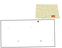
ND LaMoure County Marion.svg
Location of Marion, North Dakota
Coordinates: 46°36′26″N98°20′1″W / 46.60722°N 98.33361°W / 46.60722; -98.33361 Coordinates: 46°36′26″N98°20′1″W / 46.60722°N 98.33361°W / 46.60722; -98.33361
CountryUnited States
State North Dakota
County LaMoure
Founded1900
Area
[1]
  Total1.00 sq mi (2.60 km2)
  Land0.84 sq mi (2.17 km2)
  Water0.17 sq mi (0.43 km2)
Elevation
1,463 ft (446 m)
Population
 (2020)
  Total125
  Density149.16/sq mi (57.61/km2)
Time zone UTC-6 (CST)
  Summer (DST) UTC-5 (CDT)
ZIP code
58466
Area code 701
FIPS code 38-50780
GNIS feature ID1033654 [2]

Marion is a city in LaMoure County, North Dakota, United States. The population was 125 at the 2020 census. [3]

Contents

History

The city was founded in 1900 as Elmo, but changed its name to Marion in 1902. [4] The new name came from Marion Mellen, daughter of Northern Pacific Railway president Charles Sanger Mellen. [5] Marion was located at the end of a Northern Pacific branch line starting in Casselton and known as the "lady line" due to the many cities bearing female names located alongside the tracks. The line was in place in Marion until 2002, when eventual owner Red River Valley & Western filed for abandonment. [6]

Geography

Marion is located at 46°36′26″N98°20′1″W / 46.60722°N 98.33361°W / 46.60722; -98.33361 (46.607360, -98.333510). [7]

According to the United States Census Bureau, the city has a total area of 1.01 square miles (2.62 km2), of which 0.84 square miles (2.18 km2) is land and 0.17 square miles (0.44 km2) is water. [8]

Demographics

Historical population
CensusPop.
1910 241
1920 29422.0%
1930 258−12.2%
1940 242−6.2%
1950 27212.4%
1960 30913.6%
1970 215−30.4%
1980 214−0.5%
1990 169−21.0%
2000 146−13.6%
2010 133−8.9%
2020 125−6.0%
2021 (est.)130 [9] 4.0%
U.S. Decennial Census [10]
2020 Census [3]

2010 census

As of the census of 2010, there were 133 people, 64 households, and 36 families residing in the city. The population density was 158.3 inhabitants per square mile (61.1/km2). There were 81 housing units at an average density of 96.4 per square mile (37.2/km2). The racial makeup of the city was 98.5% White and 1.5% from two or more races.

There were 64 households, of which 18.8% had children under the age of 18 living with them, 46.9% were married couples living together, 7.8% had a female householder with no husband present, 1.6% had a male householder with no wife present, and 43.8% were non-families. 37.5% of all households were made up of individuals, and 20.3% had someone living alone who was 65 years of age or older. The average household size was 2.08 and the average family size was 2.69.

The median age in the city was 50.3 years. 15% of residents were under the age of 18; 10.7% were between the ages of 18 and 24; 18.1% were from 25 to 44; 27.1% were from 45 to 64; and 29.3% were 65 years of age or older. The gender makeup of the city was 51.1% male and 48.9% female.

2000 census

As of the census of 2000, there were 146 people, 71 households, and 40 families residing in the city. The population density was 174.4 people per square mile (67.1/km2). There were 86 housing units at an average density of 102.8 per square mile (39.5/km2). The racial makeup of the city was 98.63% White, 0.68% Asian, and 0.68% from two or more races.

There were 71 households, out of which 21.1% had children under the age of 18 living with them, 49.3% were married couples living together, 5.6% had a female householder with no husband present, and 16.2% were non-families. 40.8% of all households were made up of individuals, and 22.5% had someone living alone who was 65 years of age or older. The average household size was 2.06 and the average family size was 2.80.

In the city, the population was spread out, with 20.5% under the age of 18, 4.8% from 18 to 24, 19.9% from 25 to 44, 26.0% from 45 to 64, and 28.8% who were 65 years of age or older. The median age was 49 years. For every 100 females, there were 97.3 males. For every 100 females age 18 and over, there were 96.6 males.

The median income for a household in the city was $21,250, and the median income for a family was $24,583. Males had a median income of $39,000 versus $34,000 for females. The per capita income for the city was $31,041. There were 10.4% of families and 22.8% of the population living below the poverty line, including 25.6% of under eighteens and 27.9% of those over 64.

Education

It is in the Litchville-Marion School District. The district was formed in 2002. [11]

In passing

Marion was mentioned on the March 5, 2014 episode of "Wheel of Fortune". A former resident, Stephanie Limesand, appeared on the show.

Related Research Articles

<span class="mw-page-title-main">Denver, Iowa</span> City in Iowa, United States

Denver is a city in Bremer County in the U.S. state of Iowa. The population was 1,919 at the time of the 2020 census. It is part of the Waterloo–Cedar Falls Metropolitan Statistical Area.

<span class="mw-page-title-main">Leland, Iowa</span> City in Iowa, United States

Leland is a city in Winnebago County, Iowa, United States. The population was 249 at the time of the 2020 census.

<span class="mw-page-title-main">Chickamaw Beach, Minnesota</span> City in Minnesota, United States

Chickamaw Beach is a city in Cass County, Minnesota, United States. The population was 114 at the 2010 census. It is part of the Brainerd Micropolitan Statistical Area.

<span class="mw-page-title-main">Leonidas, Minnesota</span> City in Minnesota, United States

Leonidas is a city in Saint Louis County, Minnesota, United States. The population was 52 at the 2010 census.

<span class="mw-page-title-main">Eagle Bend, Minnesota</span> City in Minnesota, United States

Eagle Bend is a city in Todd County, Minnesota, United States. The population was 535 at the 2010 census.

<span class="mw-page-title-main">Lanagan, Missouri</span> City in Missouri, United States

Lanagan is a city in McDonald County, Missouri, United States. It is near Truitt's Cave. The population was 419 at the 2010 census.

<span class="mw-page-title-main">Royal, Nebraska</span> Village in Nebraska, United States

Royal is a village in Antelope County, Nebraska, United States. The population was 63 at the 2010 census.

<span class="mw-page-title-main">Dazey, North Dakota</span> City in North Dakota, United States

Dazey is a city in Barnes County, North Dakota, United States. The population was 78 at the 2020 census. Dazey was founded in 1883 after a local farmer, Charles Dazey, donated land to start a townsite.

<span class="mw-page-title-main">Litchville, North Dakota</span> City in North Dakota, United States

Litchville is a city in Barnes County, North Dakota, United States. The population was 169 at the 2020 census. Litchville was founded in 1900.

<span class="mw-page-title-main">Leonard, North Dakota</span> City in North Dakota, United States

Leonard is a city in Cass County, North Dakota, United States. The population was 248 at the 2020 census. Leonard was founded in 1881.

<span class="mw-page-title-main">Dickey, North Dakota</span> City in North Dakota, United States

Dickey is a city in LaMoure County, North Dakota, United States. The population was 42 at the 2020 census.

<span class="mw-page-title-main">Edgeley, North Dakota</span> City in North Dakota, United States

Edgeley is a city in LaMoure County, North Dakota, United States. The population was 585 at the 2020 census.

<span class="mw-page-title-main">Jud, North Dakota</span> City in North Dakota, United States

Jud is a rural hamlet in LaMoure County, North Dakota, United States. The population was 65 at the 2020 census. Jud was founded in 1904 and named for county settler Judson LaMoure. It is located along unpaved 61st Street SE, 9 miles (14 km) west of U.S. Route 281 and 25 miles (40 km) south of Interstate 94 in the midst of settled farmland and open plains.

<span class="mw-page-title-main">LaMoure, North Dakota</span> City in North Dakota, United States

LaMoure is a city in LaMoure County, North Dakota, United States. The population was 764 at the 2020 census. It is the county seat of LaMoure County.

<span class="mw-page-title-main">Verona, North Dakota</span> City in North Dakota, United States

Verona is a city in LaMoure County, North Dakota, United States. The population was 59 at the 2020 census. Verona was founded in 1886.

<span class="mw-page-title-main">Montpelier, North Dakota</span> City in North Dakota, United States

Montpelier is a city in Stutsman County, North Dakota, United States. The population was 85 at the 2020 census. Montpelier was founded in 1885.

<span class="mw-page-title-main">Aurora, Oregon</span> City in Oregon, United States

Aurora is a city in Marion County, Oregon, United States. Before being incorporated as a city, it was the location of the Aurora Colony, a religious commune founded in 1856 by William Keil and John E. Schmit. William named the settlement after his daughter. The population was 1,133 at the 2020 Census. It is part of the Salem Metropolitan Statistical Area.

<span class="mw-page-title-main">Marion Township, Beaver County, Pennsylvania</span> Township in Pennsylvania, United States

Marion Township is a township in Beaver County, Pennsylvania, United States. The population was 799 at the 2020 census. It is part of the Pittsburgh metropolitan area.

<span class="mw-page-title-main">Goodrich, Texas</span> City in Texas, United States

Goodrich is a city in Polk County, Texas, United States. The population was 271 at the 2010 census.

<span class="mw-page-title-main">Fairview, West Virginia</span> Town in West Virginia, United States

Fairview is a town in Marion County, West Virginia, United States. The population was 374 at the 2020 census.

References

  1. "ArcGIS REST Services Directory". United States Census Bureau. Retrieved September 20, 2022.
  2. "US Board on Geographic Names". United States Geological Survey. October 25, 2007. Retrieved January 31, 2008.
  3. 1 2 "Explore Census Data". United States Census Bureau . Retrieved July 11, 2022.
  4. Wick, Douglas A. "Marion (Lamoure County)". North Dakota Place Names. Retrieved 4 May 2011.
  5. "Profile for Marion, North Dakota". ePodunk . Retrieved May 26, 2010.
  6. "RED RIVER VALLEY & WESTERN RAILROAD COMPANY--ABANDONMENT EXEMPTION--IN LAMOURE AND BARNES COUNTIES, ND". Case AB_391_9_X. Surface Transportation Board . Retrieved May 4, 2011.
  7. "US Gazetteer files: 2010, 2000, and 1990". United States Census Bureau. February 12, 2011. Retrieved April 23, 2011.
  8. "US Gazetteer files 2010". United States Census Bureau. Archived from the original on January 25, 2012. Retrieved June 14, 2012.
  9. "City and Town Population Totals: 2020-2021". United States Census Bureau. July 11, 2022. Retrieved July 11, 2022.
  10. United States Census Bureau. "Census of Population and Housing" . Retrieved January 23, 2014.
  11. "Home". Litchville-Marion School District . Retrieved August 15, 2021. We consolidated into School District 46 in 2002.