Verona, North Dakota

Last updated

Verona, North Dakota
Fire department in Verona, North Dakota 6-12-2008.jpg
Fire department in Verona
ND LaMoure County Verona.svg
Location of Verona, North Dakota
Coordinates: 46°21′55″N98°4′17″W / 46.36528°N 98.07139°W / 46.36528; -98.07139
CountryUnited States
State North Dakota
County LaMoure
Founded1886
Area
[1]
  Total0.57 sq mi (1.49 km2)
  Land0.57 sq mi (1.49 km2)
  Water0.00 sq mi (0.00 km2)
Elevation
[2]
1,388 ft (423 m)
Population
 (2020) [3]
  Total59
  Estimate 
(2022) [4]
60
  Density102.61/sq mi (39.60/km2)
Time zone UTC-6 (Central (CST))
  Summer (DST) UTC-5 (CDT)
ZIP code
58490
Area code 701
FIPS code 38-81900
GNIS feature ID1033683 [2]

Verona is a city in LaMoure County, North Dakota, United States. The population was 59 at the 2020 census. [3] Verona was founded in 1886.

Contents

Geography

Verona is located at 46°21′55″N98°4′17″W / 46.36528°N 98.07139°W / 46.36528; -98.07139 (46.365230, -98.071423). [5]

According to the United States Census Bureau, the city has a total area of 0.25 square miles (0.65 km2), all land. [6]

Demographics

Historical population
CensusPop.Note
1910 235
1920 2589.8%
1930 222−14.0%
1940 201−9.5%
1950 189−6.0%
1960 162−14.3%
1970 140−13.6%
1980 126−10.0%
1990 103−18.3%
2000 1084.9%
2010 85−21.3%
2020 59−30.6%
2022 (est.)60 [4] 1.7%
U.S. Decennial Census [7]
2020 Census [3]

2010 census

As of the census of 2010, there were 85 people, 38 households, and 23 families residing in the city. The population density was 340.0 inhabitants per square mile (131.3/km2). There were 47 housing units at an average density of 188.0 per square mile (72.6/km2). The racial makeup of the city was 97.6% White, 1.2% Native American, and 1.2% from two or more races.

There were 38 households, of which 23.7% had children under the age of 18 living with them, 50.0% were married couples living together, 5.3% had a female householder with no husband present, 5.3% had a male householder with no wife present, and 39.5% were non-families. 31.6% of all households were made up of individuals, and 13.1% had someone living alone who was 65 years of age or older. The average household size was 2.24 and the average family size was 2.91.

The median age in the city was 45.5 years. 20% of residents were under the age of 18; 7.1% were between the ages of 18 and 24; 22.4% were from 25 to 44; 28.2% were from 45 to 64; and 22.4% were 65 years of age or older. The gender makeup of the city was 52.9% male and 47.1% female.

2000 census

As of the census of 2000, there were 108 people, 44 households, and 30 families residing in the city. The population density was 417.6 inhabitants per square mile (161.2/km2). There were 53 housing units at an average density of 205.0 per square mile (79.2/km2). The racial makeup of the city was 99.07% White and 0.93% Native American.

There were 44 households, out of which 34.1% had children under the age of 18 living with them, 54.5% were married couples living together, 6.8% had a female householder with no husband present, and 31.8% were non-families. 25.0% of all households were made up of individuals, and 13.6% had someone living alone who was 65 years of age or older. The average household size was 2.45 and the average family size was 2.97.

In the city, the population was spread out, with 25.9% under the age of 18, 2.8% from 18 to 24, 38.0% from 25 to 44, 20.4% from 45 to 64, and 13.0% who were 65 years of age or older. The median age was 37 years. For every 100 females, there were 86.2 males. For every 100 females age 18 and over, there were 95.1 males.

The median income for a household in the city was $36,875, and the median income for a family was $39,375. Males had a median income of $31,250 versus $22,250 for females. The per capita income for the city was $14,327. There were 10.8% of families and 11.2% of the population living below the poverty line, including 14.6% of under eighteens and none of those over 64.

Notable person

Climate

This climatic region is typified by large seasonal temperature differences, with warm to hot (and often humid) summers and cold (sometimes severely cold) winters. According to the Köppen Climate Classification system, Verona has a humid continental climate, abbreviated "Dfb" on climate maps. [8]

Related Research Articles

<span class="mw-page-title-main">Verona, Illinois</span> Village in Illinois, United States

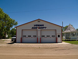
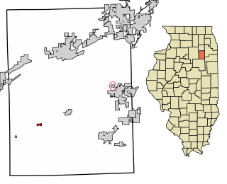
Verona is a village in Grundy County, Illinois. The population was 215 at the 2010 census.

<span class="mw-page-title-main">North Kensington, Maryland</span> Census-designated place in Maryland, United States

North Kensington is a census-designated place and an unincorporated area in Montgomery County, Maryland, United States. It had a population of 9,497 in 2020.

<span class="mw-page-title-main">Chippewa Township, Chippewa County, Michigan</span> Civil township in Michigan, United States

Chippewa Township is a civil township of Chippewa County in the U.S. state of Michigan. As of the 2010 census, the township population was 213.

Verona Township is a township in Faribault County, Minnesota, United States. The population was 391 at the 2000 census.

<span class="mw-page-title-main">Harding, Minnesota</span> City in Minnesota, United States

Harding is a city in Morrison County, Minnesota, United States, along the Platte River. The population was 123 at the 2020 census.

<span class="mw-page-title-main">Deer Creek, Minnesota</span> City in Minnesota, United States

Deer Creek is a city in Otter Tail County, Minnesota, United States. The population was 330 at the 2020 census.

<span class="mw-page-title-main">Urbank, Minnesota</span> City in Minnesota, United States

Urbank is a city in Otter Tail County, Minnesota, United States. The population was 52 at the 2020 census.

<span class="mw-page-title-main">Verona, Mississippi</span> City in Mississippi, United States

Verona is a city in Lee County, Mississippi. The population was 2,792 at the 2020 census, down from 3,006 at the 2010 census.

<span class="mw-page-title-main">Verona, Missouri</span> City in Missouri, United States

Verona is a city in Lawrence County, Missouri, United States. The population was 619 at the 2010 census, later estimated to be 826 as of July 1, 2020.

<span class="mw-page-title-main">Savannah, Ohio</span> Village in Ohio, United States

Savannah is a village in Ashland County, Ohio, United States. The population was 329 at the 2020 census.

<span class="mw-page-title-main">Brookside, Ohio</span> Village in Ohio, United States

Brookside is a village in eastern Belmont County, Ohio, United States. The population was 538 at the 2020 census. It is part of the Wheeling metropolitan area.

<span class="mw-page-title-main">Morristown, Ohio</span> Village in Ohio, United States

Morristown is a village in Belmont County, Ohio, United States. The population was 248 at the 2020 census. It is part of the Wheeling metropolitan area.

<span class="mw-page-title-main">Parkston, South Dakota</span> City in South Dakota, United States

Parkston is a city in Hutchinson County, South Dakota, United States. The population was 1,567 at the 2020 census.

<span class="mw-page-title-main">Crooks, South Dakota</span> City in South Dakota, United States

Crooks is a city in Minnehaha County, South Dakota, United States and is a suburb of Sioux Falls. The population was 1,362 at the 2020 census. Crooks was named New Hope until 1904. The town's present name honors W. A. Crooks, a local politician.

<span class="mw-page-title-main">Verona, Virginia</span> CDP in Virginia, United States

Verona is a census-designated place (CDP) in Augusta County, Virginia, United States. The population was 4,239 at the 2010 census. It is part of the Staunton–Waynesboro Micropolitan Statistical Area.

<span class="mw-page-title-main">Bancroft, West Virginia</span> Town in West Virginia, United States

Bancroft is a town in Putnam County, West Virginia, United States, along the Kanawha River. The population was 389 at the 2020 census. It is part of the Huntington–Ashland metropolitan area.

<span class="mw-page-title-main">Webster, Burnett County, Wisconsin</span> Village in Wisconsin, United States

Webster is a village in Burnett County in the U.S. state of Wisconsin. The population was 653 at the 2010 census. It is along Wisconsin Highway 35.

<span class="mw-page-title-main">Verona, Wisconsin</span> City in Wisconsin, United States

Verona is a city in Dane County, Wisconsin, in the United States and is a suburb of Madison. The population was 14,030 at the 2020 census. The city is located ten miles southwest of downtown Madison within the Town of Verona. It is part of the Madison Metropolitan Statistical Area.

Solon Springs is a town in Douglas County, Wisconsin, United States. As of the 2010 census, the town had a total population of 910. The Village of Solon Springs is located within the town. The unincorporated community of Sauntry is also located in the town.

Trempealeau is a town in Trempealeau County, Wisconsin, United States. The population was 1,618 at the 2000 census. The town surrounds the village of Trempealeau. The unincorporated communities of Centerville, West Prairie, and Wrights Corners are in the town.

References

  1. "ArcGIS REST Services Directory". United States Census Bureau. Retrieved September 20, 2022.
  2. 1 2 U.S. Geological Survey Geographic Names Information System: Verona, North Dakota
  3. 1 2 3 "Explore Census Data". United States Census Bureau . Retrieved December 14, 2023.
  4. 1 2 "City and Town Population Totals: 2020-2022". United States Census Bureau. December 14, 2023. Retrieved December 14, 2023.
  5. "US Gazetteer files: 2010, 2000, and 1990". United States Census Bureau. February 12, 2011. Retrieved April 23, 2011.
  6. "US Gazetteer files 2010". United States Census Bureau. Archived from the original on January 12, 2012. Retrieved June 14, 2012.
  7. United States Census Bureau. "Census of Population and Housing" . Retrieved January 23, 2014.
  8. Climate Summary for Verona, North Dakota