
Hobart is the capital and most populous city of the island state of Tasmania, Australia. Home to almost half of all Tasmanians, it is the southernmost and least-populated Australian state capital city, and second-smallest if territories are taken into account, before Darwin, Northern Territory. Hobart is located in Tasmania's south-east on the estuary of the River Derwent, making it the most southern of Australia's capital cities. Its skyline is dominated by the 1,271-metre (4,170 ft) kunanyi/Mount Wellington, and its harbour forms the second-deepest natural port in the world, with much of the city's waterfront consisting of reclaimed land. The metropolitan area is often referred to as Greater Hobart, to differentiate it from the City of Hobart, one of the seven local government areas that cover the city. It has a mild maritime climate.

Tasmania is an island state of Australia. It is located 240 kilometres (150 miles) to the south of the Australian mainland, separated from it by the Bass Strait, with the archipelago containing the southernmost point of the country. The state encompasses the main island of Tasmania, the 26th-largest island in the world, and the surrounding 1000 islands. It is Australia's least populous state, with 569,825 residents as of December 2021. The state capital and largest city is Hobart, with around 40 percent of the population living in the Greater Hobart area. This makes it Australia's most decentralised state.

Devonport is a port city situated at the mouth of the Mersey River on the north-west coast of Tasmania, Australia. Positioned 47 kilometres (29 mi) east of Burnie and 98 kilometres (61 mi) north of Launceston, its harbour manages over half of Tasmania's imports and exports, standing as the busiest freight port on the island. Devonport also plays a pivotal role in Tasmania's trade sector, supporting industries such as agriculture, manufacturing, and tourism. The City of Devonport's gross domestic product (GDP) was estimated at $3.5b in 2023.

The Aboriginal Tasmanians are the Aboriginal people of the Australian island of Tasmania, located south of the mainland. For much of the 20th century, the Tasmanian Aboriginal people were widely, and erroneously, thought of as being an extinct cultural and ethnic group that had been intentionally exterminated by white settlers. Contemporary figures (2016) for the number of people of Tasmanian Aboriginal descent vary according to the criteria used to determine this identity, ranging from 6,000 to over 23,000.

Truganini, also known as Lallah Rookh was an Aboriginal Tasmanian woman. She was one of the last native speakers of the Tasmanian languages and one of the last individuals solely of Aboriginal Tasmanian descent.

Risdon Cove is a cove located on the east bank of the Derwent River, approximately 7 kilometres (4 mi) north of Hobart, Tasmania. It was the site of the first British settlement in Van Diemen's Land, now Tasmania, the island state of Australia. The cove was named by John Hayes, who mapped the river in the ship Duke of Clarence in 1794, after his second officer William Bellamy Risdon.

The University of Tasmania (UTAS) is a public research university, primarily located in Tasmania, Australia. Founded in 1890, it is Australia's fourth oldest university. Christ College, one of the university's residential colleges, first proposed in 1840 in Lieutenant-Governor Sir John Franklin's Legislative Council, was modelled on the Oxford and Cambridge colleges, and was founded in 1846, making it the oldest tertiary institution in the country. The university is a sandstone university, a member of the international Association of Commonwealth Universities, and the Association of Southeast Asian Institutions of Higher Learning.

Low Head is a rural residential locality in the local government area (LGA) of George Town in the Launceston LGA region of Tasmania. The locality is about 5 kilometres (3.1 mi) north of the town of George Town. The 2016 census recorded a population of 572 for the state suburb of Low Head. It is a suburb of George Town, on a peninsula at the mouth of the Tamar River.

The Clarke Island, part of the Furneaux Group, is an 82-square-kilometre (32 sq mi) island in Bass Strait, south of Cape Barren Island, about 24 kilometres (15 mi) off the northeast coast of Tasmania, Australia. Banks Strait separates the island from Cape Portland on the mainland.
Eaglehawk Neck, officially Teralina / Eaglehawk Neck, is a narrow isthmus that connects the Tasman Peninsula with the Forestier Peninsula and hence to the rest of Tasmania, Australia.

The Tasmanian Museum and Art Gallery (TMAG) is a museum located in Hobart, Tasmania. The museum was established in 1846, by the Royal Society of Tasmania, the oldest Royal Society outside England. The TMAG receives 400,000 visitors annually.
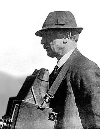
John Watt Beattie was an Australian photographer.

HMS Nairana was a passenger ferry that was requisitioned by the Royal Navy (RN) as a seaplane carrier in 1917. She was laid down in Scotland in 1914 as TSS Nairana for the Australian shipping line Huddart Parker, but construction was suspended after the outbreak of the First World War. Following resumption of work, the ship was launched in 1915, and converted to operate wheeled aircraft from her forward flying-off deck, as well as floatplanes that were lowered into the water. She saw service during the war with the Grand Fleet, and in 1918–19 supported the British intervention in the Russian Civil War.

Smooth Island, is a privately owned island with an area of 59.31 ha lying close to the south-eastern coast of Tasmania, Australia. The island is part of the Sloping Island Group situated in Norfolk Bay and surrounded by the Tasman and Forestier Peninsulas. The towns Dunalley and Murdunna are nearby. Smooth Island differs from other Tasmanian islands as it has an unencumbered freehold title down to the high-water mark.

The Steam Yacht Ena is a steam yacht that was built in 1900 for Thomas Dibbs, the commodore of the Royal Sydney Yacht Squadron. It was used as his private vessel for entertaining guests on Sydney Harbour and Pittwater until the beginning of World War I. In 1917 the yacht was purchased by the Royal Australian Navy (RAN) and used as the auxiliary patrol vessel HMAS Sleuth in the waters around the Torres Strait and Thursday Island, before later being used as a training ship tender based in Sydney.
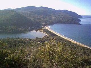
Oyster Cove is a semi-rural locality in the local government areas (LGA) of Kingborough and Huon Valley in the Hobart and South-east LGA regions of Tasmania. The locality is about 20 kilometres (12 mi) south-west of the town of Kingston. The 2016 census has a population of 319 for the state suburb of Oyster Cove.

Isle of the Dead is an island, about 1 hectare in area, adjacent to Port Arthur, Tasmania, Australia. It is historically significant since it retains an Aboriginal coastal shell midden, one of the first recorded sea-level benchmarks, and one of the few preserved Australian convict-period burial grounds. The Isle of the Dead occupies part of the Port Arthur Historic Site, is part of Australian Convict Sites and is listed as a World Heritage Property because it represents convictism in the era of British colonisation.
The Tasmanian Seafarers' Memorial is a public memorial structure located at Triabunna, Tasmania which jointly commemorates all Tasmanians who died at sea, along with the lives of all seafarers of any origin who lost their lives in Tasmanian waters. The memorial comprises individual commemorative plaques for each maritime tragedy involving recreational, commercial, mercantile or naval vessels and personnel lost since 1803. As of February 2017, the memorial contained plaques for 116 events involving the loss of over 1450 lives.
Angela McGowan is an Australian archaeologist known for her work on Aboriginal and European heritage and culture in Tasmania, Australia. McGowan predominantly worked in Heard Island, off the coast of Antarctica and Tasmania.

