
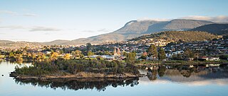
Hobart is the capital and most populous city of the island state of Tasmania, Australia. Home to almost half of all Tasmanians, it is the southernmost and least-populated Australian state capital city, and second-smallest if territories are taken into account, before Darwin. Hobart is located in Tasmania's south-east on the estuary of the River Derwent, making it the most southern of Australia's capital cities. Its skyline is dominated by the 1,271-metre (4,170 ft) kunanyi / Mount Wellington, and its harbour forms the second-deepest natural port in the world, with much of the city's waterfront consisting of reclaimed land. The metropolitan area is often referred to as Greater Hobart, to differentiate it from the City of Hobart, one of the seven local government areas that cover the city. It has a mild maritime climate.
Councils of Tasmania are the 29 administrative districts of the Australian state of Tasmania. Local government areas (LGAs), more generally known as councils, are the tier of government responsible for the management of local duties such as road maintenance, town planning and waste management.
Glenorchy is a suburb of Hobart, in the state of Tasmania, Australia. Glenorchy is bound by the River Derwent to the east, Mount Wellington to the west, Hobart City to the south and Brighton to the north. The city officially begins at Creek Road New Town, in Hobart's northern suburbs, and includes, Moonah, Derwent Park, Lutana, Goodwood, Montrose, Rosetta, Berriedale, Chigwell, Claremont and Austins Ferry. It is the seat of the local government area of the same name, the City of Glenorchy.

Clarence City Council is a local government body in Tasmania, and one of the five municipalities that constitutes the Greater Hobart Area. The Clarence local government area has a population of 61,531, covering the eastern shore of the Derwent River from Otago to the South Arm Peninsula and the smaller localities of Cambridge, Richmond, and Seven Mile Beach.

The Brooker Highway is a highway in the Australian state of Tasmania. As one of Hobart's three major radials, the highway connects traffic from the city centre with the northern suburbs and is the major road connection to the cities and towns of northern Tasmania. With an annual average daily traffic of 48,000, the highway is one of the busiest in Tasmania. The Brooker Highway has recently been declared part of the National Highway.

Glenorchy City Council is a local government body in Tasmania, and one of the five municipalities that constitutes the Greater Hobart Area. The Glenorchy local government area has a population of 50,411, covering the suburbs north of central Hobart on the western shore of the Derwent River, including its namesake suburb, Glenorchy.

The Derwent Entertainment Centre (DEC), known commercially as MyState Bank Arena since 2021, is Tasmania's largest indoor arena, serving as Hobart's primary location for large indoor sporting events, functions and live entertainment. Commissioned by the Tasmanian Government and the Glenorchy City Council, the DEC served as the home arena for the Hobart Devils in the NBL from 1989 until 1996, when the team's licence was revoked. Subsequently, between 1997 and 1998, ownership was transferred entirely to the City of Glenorchy, where it became a financial burden and incurred significant maintenance expenses for Glenorchy taxpayers, while seeing limited use. As the largest enclosed multipurpose venue in Tasmania, the DEC has hosted many Australian and international musical acts, including Kylie Minogue, Bob Dylan, Carole King, The Corrs, James Brown, Leonard Cohen, Tina Turner, Blondie and The Beach Boys.
Rosetta is a residential suburb about 3 kilometres (1.9 mi) northwest of Glenorchy, located in local government area (LGA) of City of Glenorchy. In the 2021 census, Rosetta had a population of 2,833. This suburb is part of the Hobart LGA Region, nestled between Berriedale and Montrose and roughly a 15-minute drive from Hobart. Rosetta features a primary school and a high school and is bordered by the Brooker Highway along the east, adjacent to the Derwent River.

Montrose is a residential locality in the local government area (LGA) of Glenorchy in the Hobart LGA region of Tasmania. The locality is about 1 kilometre (0.62 mi) north of the town of Glenorchy. The 2016 census recorded a population of 2152 for the state suburb of Montrose. It is a suburb of Hobart. The suburb is situated in close proximity with Rosetta. Montrose is the suburb directly north of Glenorchy. It is also in Montrose where the Montrose Foreshore Community Park is located.

West Moonah is a residential suburb of Hobart, Tasmania, Australia. It is part of the City of Glenorchy local government area, with about 5% being in the Hobart LGA. At the 2016 Australian census, the suburb recorded a population of approximately 1,000.

Derwent Park is a residential locality in the local government area (LGA) of Glenorchy in the Hobart LGA region of Tasmania. The locality is about 2 kilometres (1.2 mi) east of the town of Glenorchy. The 2016 census recorded a population of 657 for the state suburb of Derwent Park. It is a suburb of Hobart.
Dowsing Point is a residential locality in the local government area (LGA) of Glenorchy in the Hobart LGA region of Tasmania. The locality is about 2 kilometres (1.2 mi) north-east of the town of Glenorchy. The 2016 census recorded a population of 85 for the state suburb of Dowsing Point.

Rose Bay is a suburb of the City of Clarence in greater Hobart, capital city of Tasmania, Australia. Rose Bay is a small suburb, making up only approximately 0.9 square kilometres with nearly one fourth of that area (23.2%) being parkland. At the 2016 Census the suburb recorded a population of 1,102 people.

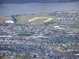
Elwick Racecourse is a Thoroughbred horse-racing venue located on Goodwood Road within Glenorchy, Tasmania, Australia. It is located in close proximity to the Brooker Highway, Hobart Showground, Derwent Entertainment Centre, Glenorchy Art and Sculpture Park and the River Derwent. The Racecourse has a picturesque outlook across the river, as well as being dominated by views of kunanyi / Mount Wellington. Elwick features at least 110 race meetings and 210 trial days a year, but is most well known for hosting the Hobart Cup.

Goodwood Road is a 4-lane link road that connects the City of Glenorchy to the City of Clarence in the greater area of Hobart, Tasmania. Using the Bowen Bridge the road travels over the River Derwent in semi-highway road layout. The road starts 10 km north of the Hobart CBD near the Hobart Showground on the Brooker Highway at Glenorchy, from there it travels east past the Elwick Racecourse, over the Bowen Bridge and connects to the East Derwent Highway at Otago. While the route the road takes is used far less than other major arterial roads in Hobart, commuters often depend on the road when major incidents occur on other major roads throughout Hobart.
Elwick Road is a major arterial road that runs through the northern suburbs of Hobart, Tasmania. The road is the major link road between the Main Road and the Brooker Highway that connects to Glenorchy. Elwick passes through residential areas.
The city of Hobart, Tasmania is served by a wide variety of transport. While the city's main form of transport is private transport on the road network, transport is also available by bus, ferry and aircraft. A suburban train service operated between Hobart and Brighton from the 1870s until 31 December 1974. There has been, however, talk in recent years of reinstating a train service in the northern suburbs.
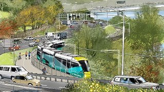
Riverline, also known as the Northern Suburbs Railway, was a proposed light rail system that would have traversed the southernmost section of the South Railway Line, through the northern suburbs of Hobart, Tasmania.
The Tasmanian Heritage Register is the statutory heritage register of the Australian state of Tasmania. It is defined as a list of areas currently identified as having historic cultural heritage importance to Tasmania as a whole. The Register is kept by the Tasmanian Heritage Council within the meaning of the Tasmanian Historic Cultural Heritage Act 1995. It encompasses in addition the Heritage Register of the Tasmanian branch of the National Trust of Australia, which was merged into the Tasmanian Heritage Register. The enforcement of the heritage's requirements is managed by Heritage Tasmania.

Periodic elections for the Tasmanian Legislative Council were held on 4 May 2024. The two seats up for periodic election were Hobart and Prosser. A by-election for the seat of Elwick was also held concurrently.

