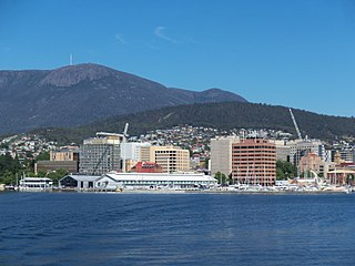
Hobart is the capital and most populous city of the island state of Tasmania, Australia. Home to almost half of all Tasmanians, it is the southernmost and least-populated Australian state capital city, and second-smallest if territories are taken into account, before Darwin. Hobart is located in Tasmania's south-east on the estuary of the River Derwent, making it the most southern of Australia's capital cities. Its skyline is dominated by the 1,271-metre (4,170 ft) kunanyi / Mount Wellington, and its harbour forms the second-deepest natural port in the world, with much of the city's waterfront consisting of reclaimed land. The metropolitan area is often referred to as Greater Hobart, to differentiate it from the City of Hobart, one of the seven local government areas that cover the city. It has a mild maritime climate.

Launceston is a city in the north of Tasmania, Australia, at the confluence of the North Esk and South Esk rivers where they become the Tamar River (kanamaluka). As of 2021, the Launceston urban area has a population of 90,953. Launceston is the second most populous city in Tasmania after the state capital, Hobart. As of 2020, Launceston is the 18th largest city in Australia. Launceston is the fifth-largest inland city and the ninth-largest non-capital city in Australia. Launceston is regarded as the most livable regional city, and was one of the most popular regional cities to move to in Australia from 2020 to 2021. Launceston was named Australian Town of the Year in 2022.
The history of Tasmania begins at the end of the Last Glacial Period when it is believed that the island was joined to the Australian mainland. Little is known of the human history of the island until the British colonisation of Tasmania in the 19th century.

The Midland Highway is one of Tasmania's major inter-city highways, running for 176 kilometres (109 mi) between Hobart and Launceston. It is part of the AusLink National Network and is a vital link for road freight to transport goods to and from the two cities. It represents a major north–south transportation corridor in Tasmania and has the route 1 designation as part of the National Highway. The highway consists of various traffic lane arrangements, the most common being two lanes – one in each direction, with overtaking options and at-grade intersections. At both the Launceston and Hobart sections of the highway there are small portions of grade-separated dual carriageway.

The Brooker Highway is a highway in the Australian state of Tasmania. As one of Hobart's three major radials, the highway connects traffic from the city centre with the northern suburbs and is the major road connection to the cities and towns of northern Tasmania. With an annual average daily traffic of 48,000, the highway is one of the busiest in Tasmania. The Brooker Highway has recently been declared part of the National Highway.

The Tasman Highway is a highway in Tasmania, Australia. Like the Midland Highway, it connects the major cities of Hobart and Launceston – however it takes a different route, via the north-eastern and eastern coasts of the state. The Highway also acts as a major commuter road to Hobart residents living on the eastern side of the Derwent River. The designation "Tasman Highway" arises from its location facing the Tasman Sea – named, like the state itself, after Abel Tasman. The highway is one of the longest in Tasmania – 410 km (250 mi), with an average travelling time of 41⁄2 hours.

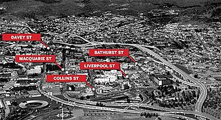
Davey Street is a major one way street passing through the outskirts of the Hobart City Centre in Tasmania, Australia. Davey street is named after Thomas Davey, the first Governor of Van Diemen's Land. The street forms a one-way couplet with nearby Macquarie Street connecting traffic from the Southern Outlet in the south with traffic from the Tasman Highway to the east and the Brooker Highway to the north of the city. With annual average daily traffic of 37,200, the road is one of the busier streets in Hobart.

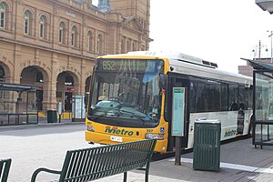
Metro Tasmania, commonly called Metro, a Tasmanian Government business enterprise, is the largest bus operator in the state of Tasmania, Australia, with operations in three of the four largest urban centres of Hobart, Launceston, and Burnie. Urban services in Devonport are provided by a private operator, Kinetic. Services are provided by Metro under a range of urban and non-urban contracts with the Transport Commission, a division within the Department of State Growth.

Rose Bay is a suburb of the City of Clarence in greater Hobart, capital city of Tasmania, Australia. Rose Bay is a small suburb, making up only approximately 0.9 square kilometres with nearly one fourth of that area (23.2%) being parkland. At the 2016 Census the suburb recorded a population of 1,102 people.
The city of Hobart, Tasmania is served by a wide variety of transport. While the city's main form of transport is private transport on the road network, transport is also available by bus, ferry and aircraft. A suburban train service operated between Hobart and Brighton from the 1870s until 31 December 1974. There has been, however, talk in recent years of reinstating a train service in the northern suburbs.
Hobart City Centre is a suburb surrounded by metropolitan Hobart, which comprises the original settlement, the central business district, and other built-up areas. It is the oldest part of Hobart and includes many of the city's important institutions and landmarks, such as Parliament, the Supreme Court, Franklin Square, the Elizabeth Street Mall, the Royal Hobart Hospital, the Theatre Royal, Odeon Theatre, State Library, the NAB Building, the Museum, and the Cenotaph. The city centre is located in the local government areas of the City of Hobart.

The South Line, also known as the Main Line and sometimes the North/South Line or the North–South Line, is a rail corridor connecting Hobart to the northern ports of Tasmania. The Railway Line was built by the Tasmanian Main Line Company.

Trams no longer operate in Hobart, the capital of the Australian state of Tasmania, but the city once had an extensive and popular system that reached the majority of its suburbs. It was the first complete electric tram system in the Southern Hemisphere, and the only one in Australia to operate double-decker trams.

The Hotel Grand Chancellor Hobart is a twelve-storey hotel located on the waterfront of Hobart, Tasmania, Australia.
The Hobart Bypass is a proposed concept to bypass the Central Business District of Hobart, Tasmania. Currently, through traffic travels from the Tasman/Brooker Highways down the one-way Davey/Macquarie couplet to the Southern Outlet. As well as traffic concerns, there is also a call to build the bypass on the grounds that the current traffic arrangement cuts the central business district off from Hobart's waterfront.

The Hobart trolleybus system operated in Hobart, Tasmania, Australia from 1935 until 1968.
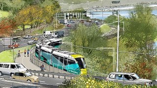
Riverline, also known as the Northern Suburbs Railway, was a proposed light rail system that would have traversed the southernmost section of the South Railway Line, through the northern suburbs of Hobart, Tasmania.

Franklin Square is a 1.6-acre (0.63-hectare) oak-lined public square located in the Hobart City Centre in Tasmania, Australia. It is named for Sir John Franklin, an Arctic explorer and former Lieutenant-Governor of Van Diemen's Land. The centrepiece of the park is a statue of Franklin, with an epitaph written by Alfred, Lord Tennyson. As the city's most central urban parkland and transportation hub, Franklin Square is frequently utilised for festive markets, public gatherings and as a place for public protest.

Liverpool Street is a street in the Hobart City Centre, in the state of Tasmania.

The Launceston tramway network served the city of Launceston, Tasmania in Australia from 1911 until 1952.