
Isabel is a city in Barber County, Kansas, United States. As of the 2020 census, the population of the city was 68.

Everest is a city in Brown County, Kansas, United States. As of the 2020 census, the population of the city was 265.

Protection is a city in Comanche County, Kansas, United States. As of the 2020 census, the population of the city was 498.

Arcadia is a city in northeast Crawford County, Kansas, United States. As of the 2020 census, the population of the city was 254.

Denton is a city in Doniphan County, Kansas, United States. As of the 2020 census, the population of the city was 130.

Gove City, more commonly known as Gove, is a city in and the county seat of Gove County, Kansas, United States. As of the 2020 census, the population of the city was 80.

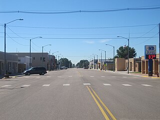
Ensign is a city in Gray County, Kansas, United States. As of the 2020 census, the population of the city was 166. It is located along U.S. Route 56 highway.

Jetmore is a city in and the county seat of Hodgeman County, Kansas, United States. As of the 2020 census, the population of the city was 770.

Randall is a city in Jewell County, Kansas, United States. As of the 2020 census, the population of the city was 79.

Edgerton is a city in Johnson County, Kansas, United States, and part of the Kansas City metropolitan area. As of the 2020 census, the population of the city was 1,748. It is home to a large BNSF intermodal train facility named Logistics Park Kansas City.
Lakin is a city in and the county seat of Kearny County, Kansas, United States. As of the 2020 census, the population of the city was 2,205. It is located along Highway 50.

Kingman is a city in and the county seat of Kingman County, Kansas, United States. As of the 2020 census, the population of the city was 3,105.

Neosho Rapids is a city in Lyon County, Kansas, United States. As of the 2020 census, the population of the city was 229.

Meade is a city in and the county seat of Meade County, Kansas, United States. As of the 2020 census, the population of the city was 1,505.

Ness City is a city in and the county seat of Ness County, Kansas, United States. As of the 2020 census, the population of the city was 1,329. Ness City is famous for its four-story Old Ness County Bank Building located downtown and nicknamed Skyscraper of the Plains.

Belvue is a city in Pottawatomie County, Kansas, United States. As of the 2020 census, the population of the city was 177.

Atwood is a city in and the county seat of Rawlins County, Kansas, United States. As of the 2020 census, the population of the city was 1,290.

Plevna is a city in Reno County, Kansas, United States. As of the 2020 census, the population of the city was 85.

Cheney is a city in Sedgwick County, Kansas, United States. As of the 2020 census, the population of the city was 2,181.
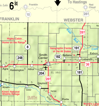
Gaylord is a city in Smith County, Kansas, United States. As of the 2020 census, the population of the city was 87.


