Mead, Wisconsin

Last updated
Mead, Wisconsin
WIMap-doton-Mead.png
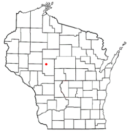
Location of Mead, Wisconsin
Coordinates: 44°47′46″N90°44′2″W / 44.79611°N 90.73389°W / 44.79611; -90.73389 Coordinates: 44°47′46″N90°44′2″W / 44.79611°N 90.73389°W / 44.79611; -90.73389
Country Flag of the United States.svg  United States
State Flag of Wisconsin.svg  Wisconsin
County Clark
Area
  Total35.7 sq mi (92.4 km2)
  Land35.1 sq mi (91.0 km2)
  Water0.5 sq mi (1.4 km2)
Elevation
[1]
1,063 ft (324 m)
Population
 (2000)
  Total290
  Density8.3/sq mi (3.2/km2)
Time zone UTC-6 (Central (CST))
  Summer (DST) UTC-5 (CDT)
Area code(s) 715 & 534
FIPS code 55-50275 [2]
GNIS feature ID1583679 [1]

Mead is a town in Clark County in the U.S. state of Wisconsin. The population was 290 at the 2000 census.

Contents

Geography

According to the United States Census Bureau, the town has a total area of 35.7 square miles (92.4 km2), of which, 35.1 square miles (91.0 km2) of it is land and 0.5 square miles (1.4 km2) of it (1.51%) is water.

Demographics

As of the census [2] of 2000, there were 290 people, 115 households, and 80 families residing in the town. The population density was 8.3 people per square mile (3.2/km2). There were 239 housing units at an average density of 6.8 per square mile (2.6/km2). The racial makeup of the town was 95.86% White, 1.72% Native American, and 2.41% from two or more races.

There were 115 households, out of which 26.1% had children under the age of 18 living with them, 57.4% were married couples living together, 5.2% had a female householder with no husband present, and 29.6% were non-families. 24.3% of all households were made up of individuals, and 7.8% had someone living alone who was 65 years of age or older. The average household size was 2.52 and the average family size was 3.04.

In the town, the population was spread out, with 27.2% under the age of 18, 4.8% from 18 to 24, 23.1% from 25 to 44, 30.0% from 45 to 64, and 14.8% who were 65 years of age or older. The median age was 39 years. For every 100 females, there were 116.4 males. For every 100 females age 18 and over, there were 119.8 males.

The median income for a household in the town was $31,875, and the median income for a family was $37,692. Males had a median income of $25,156 versus $16,250 for females. The per capita income for the town was $13,459. About 14.9% of families and 20.0% of the population were below the poverty line, including 38.0% of those under the age of eighteen and 11.5% of those 65 or over.

Related Research Articles

Crystal, Maine Town in Maine, United States

Crystal is a town in Aroostook County, Maine, United States. The population was 269 at the 2010 census.

Littleton, Maine Town in Maine, United States

Littleton is a town in Aroostook County, Maine, United States. The population was 1,068 at the 2010 census.

New Canada, Maine Town in Maine, United States

New Canada is a town in Aroostook County, Maine, United States. The population was 321 at the 2010 census.

West Gardiner, Maine Town in Maine, United States

West Gardiner is a town in Kennebec County, Maine, United States. The population was 3,474 at the 2010 census. West Gardiner is included in the Augusta, Maine micropolitan New England City and Town Area.

Stow, Maine Town in Maine, United States

Stow is a town in Oxford County, Maine, United States. The population was 385 at the 2010 census.

Junior, West Virginia Town in West Virginia, United States

Junior is a town in Barbour County, West Virginia in the US, along the Tygart Valley River. The population was 520 at the 2010 census.

Bayard, West Virginia Town in West Virginia, United States

Bayard is a town in Grant County, West Virginia, United States. The population was 290 at the 2010 census. Bayard was incorporated in 1893 and named in honor of Thomas F. Bayard, Jr., who later became a United States Senator from Delaware (1923–1929). Bayard was founded on the West Virginia Central and Pittsburgh Railroad as a coal mining community. Coal mining has remained the town's chief industry.

Quinwood, West Virginia Town in West Virginia, United States

Quinwood is a town and former coal town in Greenbrier County, West Virginia, United States. The population was 290 at the 2010 census.

Grant, Dunn County, Wisconsin Town in Wisconsin, United States

Grant is a town in Dunn County, Wisconsin, United States. The population was 426 at the 2000 census.

Waterloo, Grant County, Wisconsin Town in Wisconsin, United States

Waterloo is a town in Grant County in the U.S. state of Wisconsin. The population was 557 at the 2000 census. The unincorporated communities of Burton and McCartney is located in the town.

Spring Grove, Wisconsin Town in Wisconsin, United States

Spring Grove is a town in Green County, Wisconsin, United States. The population was 861 at the 2000 census. The unincorporated communities of Oakley and Tyrone are located in the town. The ghost town of Clarence was also located in the town.

Eaton, Manitowoc County, Wisconsin Town in Wisconsin, United States

Eaton is a town in Manitowoc County, Wisconsin, United States. The population was 761 at the 2000 census. The unincorporated community of Steinthal is located in the town.

Bergen, Marathon County, Wisconsin Town in Wisconsin, United States

Bergen is a town in Marathon County, Wisconsin, United States. It is part of the Wausau, Wisconsin Metropolitan Statistical Area. The population was 641 at the 2010 census. The unincorporated community of Moon is located partially in the town.

Ridgeville, Wisconsin Town in Wisconsin, United States

Ridgeville is a town in Monroe County, Wisconsin, United States. The population was 491 at the 2000 census. The unincorporated community of Ridgeville is in the town.

Big Falls is a town in Rusk County, Wisconsin, United States. The population was 107 at the 2000 census.

Lac La Belle, Wisconsin Village in Wisconsin, United States

Lac La Belle is a village located mostly in Waukesha County in the U.S. state of Wisconsin. The population was 290 at the 2010 census. Of this, 289 were in Waukesha County, and one person was in Jefferson County. The village is located mostly within the town of Oconomowoc in Waukesha County. On March 28, 2002, the village annexed a portion of land in the town of Ixonia in Jefferson County.

Clyman is a town in Dodge County, Wisconsin, United States. The population was 849 at the 2000 census. The Village of Clyman is located within the town. The unincorporated community of Clyman Junction is also located in the town of Clyman.

Clear Lake is a town in Polk County, Wisconsin, United States. The population was 800 at the 2000 census. The Village of Clear Lake is located within the town.

West Bend (town), Wisconsin Town in Wisconsin, United States

West Bend is a town in Washington County, Wisconsin, United States. The population was 4,834 at the 2000 census. The City of West Bend is located partially within the town. The unincorporated community of Nabob is located in the town.

Coloma is a town in Waushara County, Wisconsin, United States. The population was 748 at the 2000 census. The Village of Coloma is located within the town.

References

  1. 1 2 "US Board on Geographic Names". United States Geological Survey. 2007-10-25. Retrieved 2008-01-31.
  2. 1 2 "U.S. Census website". United States Census Bureau . Retrieved 2008-01-31.