Pine Valley, Wisconsin

Last updated

Pine Valley, Wisconsin
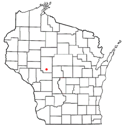
WIMap-doton-Pine Valley.png
Location of Pine Valley, Wisconsin
Coordinates: 44°33′13″N90°36′52″W / 44.55361°N 90.61444°W / 44.55361; -90.61444
Country Flag of the United States.svg  United States
State Flag of Wisconsin.svg  Wisconsin
County Clark
Area
  Total33.5 sq mi (86.8 km2)
  Land33.3 sq mi (86.3 km2)
  Water0.2 sq mi (0.5 km2)
Elevation
[1]
1,037 ft (316 m)
Population
 (2000)
  Total1,121
  Density33.6/sq mi (13.0/km2)
Time zone UTC-6 (Central (CST))
  Summer (DST) UTC-5 (CDT)
Area code(s) 715 & 534
FIPS code 55-63000 [2]
GNIS feature ID1583927 [1]

Pine Valley is a town in Clark County in the U.S. state of Wisconsin. The population was 1,121 at the 2000 census. The unincorporated community of Sidney is located in the town.

Contents

Geography

According to the United States Census Bureau, the town has a total area of 33.5 square miles (86.8 km2), of which, 33.3 square miles (86.3 km2) of it is land and 0.2 square miles (0.5 km2) of it (0.54%) is water.

Demographics

As of the census [2] of 2000, there were 1,121 people, 421 households, and 309 families residing in the town. The population density was 33.6 people per square mile (13.0/km2). There were 464 housing units at an average density of 13.9 per square mile (5.4/km2). The racial makeup of the town was 98.57% White, 0.09% African American, 0.89% Native American, and 0.45% from two or more races. Hispanic or Latino of any race were 0.98% of the population.

There were 421 households, out of which 33.5% had children under the age of 18 living with them, 62.5% were married couples living together, 5.2% had a female householder with no husband present, and 26.6% were non-families. 20.0% of all households were made up of individuals, and 10.2% had someone living alone who was 65 years of age or older. The average household size was 2.66 and the average family size was 3.08.

In the town, the population was spread out, with 27.1% under the age of 18, 6.4% from 18 to 24, 27.3% from 25 to 44, 25.4% from 45 to 64, and 13.7% who were 65 years of age or older. The median age was 39 years. For every 100 females, there were 101.3 males. For every 100 females age 18 and over, there were 108.4 males.

The median income for a household in the town was $37,813, and the median income for a family was $45,481. Males had a median income of $30,847 versus $20,781 for females. The per capita income for the town was $18,736. About 4.0% of families and 6.1% of the population were below the poverty line, including 9.0% of those under age 18 and 5.0% of those age 65 or over.

Related Research Articles

<span class="mw-page-title-main">Hartford, Alabama</span> City in Alabama, United States

Hartford is a city in Geneva County, Alabama, United States. It incorporated in 1896. It is part of the Dothan, Alabama Metropolitan Statistical Area. At the 2020 census, the population was 2,651, an increase over the figure of 2,624 tabulated in 2010.

<span class="mw-page-title-main">Kennard, Indiana</span> Town in Indiana, United States

Kennard is a town in Greensboro Township, Henry County, Indiana, United States. The population was 471 at the 2010 census.

<span class="mw-page-title-main">Topeka, Indiana</span> Town in Indiana, United States

Topeka is a town in Clearspring and Eden townships, LaGrange County, Indiana, United States. The population was 1,153 at the 2010 census. Topeka is located approximately eleven miles south of Shipshewana, Indiana.

<span class="mw-page-title-main">Saratoga, Indiana</span> Town in Indiana, United States

Saratoga is a town in Ward Township, Randolph County, in the U.S. state of Indiana. The population was 254 at the 2010 census.

<span class="mw-page-title-main">Edgewood, Iowa</span> City in Iowa, United States

Edgewood is a city in Clayton and Delaware counties in the U.S. state of Iowa. Highway 3, which runs through the center of town, is the dividing line between the two counties. The Edgewood post office was established in 1852 on the Clayton side of the town. Edgewood was formally incorporated in 1892, although it had a functioning council for some time before that date. The population was 909 at the time of the 2020 census, down from 923 in 2000.

<span class="mw-page-title-main">Canton, Maine</span> Town in the state of Maine, United States

Canton is a town in Oxford County, Maine, United States. Canton is included in the Lewiston-Auburn, Maine metropolitan New England city and town area. The population was 1,125 at the 2020 census. Located beside Lake Anasagunticook, Canton is a summer recreational area.

<span class="mw-page-title-main">Monroe, Maine</span> Town in the state of Maine, United States

Monroe is a town in Waldo County, Maine, United States named for President James Monroe. The population was 931 at the 2020 census.

<span class="mw-page-title-main">Denham, Minnesota</span> City in Minnesota, United States

Denham is a city in Pine County, Minnesota, United States. The population was 37 at the 2020 census.

<span class="mw-page-title-main">Grandview, Missouri</span> City in Missouri, United States

Grandview is a city in Jackson County, Missouri, United States. The population was 24,475 at the 2010 census. It is part of the Kansas City metropolitan area.

<span class="mw-page-title-main">Icard, North Carolina</span> Census-designated place in North Carolina, United States

Icard is a census-designated place (CDP) in Burke County, North Carolina, United States. The population was 2,664 at the 2010 census. It is part of the Hickory–Lenoir–Morganton Metropolitan Statistical Area.

<span class="mw-page-title-main">Strasburg, Ohio</span> Village in Ohio, United States

Strasburg is a village in Tuscarawas County, Ohio, United States. The population was 2,735 at the 2020 census.

<span class="mw-page-title-main">Blythe Township, Pennsylvania</span> Township in Pennsylvania, United States

Blythe Township is a township in Schuylkill County, Pennsylvania. Formed in 1846 from part of Schuylkill Township, it is named for State Legislator Calvin Blythe.

Pine Ridge is a town in Lexington County, South Carolina, United States. The population was 2,064 at the 2010 census. It is part of the Columbia, South Carolina Metropolitan Statistical Area.

<span class="mw-page-title-main">Pine Grove, West Virginia</span> Town in West Virginia, United States

Pine Grove is a town in Wetzel County, West Virginia, United States. The population was 363 at the 2020 census. The community was named for a grove of pine trees near the original town site.

<span class="mw-page-title-main">Portland, Dodge County, Wisconsin</span> Town in Wisconsin, United States

Portland is a town in Dodge County, Wisconsin, United States. The population was 1,106 at the 2000 census. The unincorporated community of Portland is located partially in the town.

<span class="mw-page-title-main">Stiles, Wisconsin</span> Town in Wisconsin, United States

Stiles is a town in Oconto County, Wisconsin, United States. The population was 1,465 at the 2000 census. The unincorporated communities of Stiles and Stiles Junction are located in the town. Situated within ancestral Menominee territory that was ceded to the United States in the 1836 Treaty of the Cedars, its Menominee name is Pæhkuahkiw which means "pointed hillock".

<span class="mw-page-title-main">Pine Lake, Wisconsin</span> Town in Wisconsin, United States

Pine Lake is a town in Oneida County, Wisconsin. The population was 2,720 at the time of the 2000 census. The unincorporated community of Roosevelt is located in the town.

<span class="mw-page-title-main">Pine Haven, Wyoming</span> Town in Wyoming, United States

Pine Haven is a town in Crook County, Wyoming, United States. The population was 493 at the 2020 census.

<span class="mw-page-title-main">Meridian Hills, Indiana</span> Town in Indiana, United States

Meridian Hills is a town in Washington Township, Marion County, Indiana, about 8 miles (13 km) north of downtown Indianapolis. It had a population of 1,774 at the 2020 census, up from 1,616 in 2010.

Elk Mound is a town in Dunn County, Wisconsin, United States. The population was 1,121 according to the 2000 census. The town is named after the Village of Elk Mound, located in the eastern part of the town.

References

  1. 1 2 "US Board on Geographic Names". United States Geological Survey. October 25, 2007. Retrieved January 31, 2008.
  2. 1 2 "U.S. Census website". United States Census Bureau . Retrieved January 31, 2008.