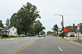
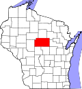
Abbotsford, Wisconsin

Last updated

Abbotsford, Wisconsin
2009-0620-Abbotsford-1st.jpg
First Street, downtown Abbotsford
Nickname: 
Wisconsin's First City
Clark County Wisconsin Incorporated and Unincorporated areas Abbotsford Highlighted.svg
Location of Abbotsford in Clark County
and Marathon County, Wisconsin.
Coordinates: 44°56′48″N90°19′6″W / 44.94667°N 90.31833°W / 44.94667; -90.31833
Country United States
State Wisconsin
Counties Clark, Marathon
Government
  MayorJames Weix
Area
[1]
  Total3.03 sq mi (7.86 km2)
  Land3.03 sq mi (7.86 km2)
  Water0.00 sq mi (0.00 km2)
Elevation
[2]
1,407 ft (429 m)
Population
 (2020) [3]
  Total2,275
Time zone UTC-6 (Central (CST))
  Summer (DST) UTC-5 (CDT)
ZIP Code
54405
Area codes 715 & 534
FIPS code 55-00100 [4]
GNIS feature ID1560663 [2]
Website cityofabbotsfordwi.gov

Abbotsford is a city in Clark (mostly) and Marathon counties in the U.S. state of Wisconsin. The population was 2,275 at the 2020 census. [5] Of this, 1,665 were in Clark County, and 610 were in Marathon County. Abbotsford is nicknamed "Wisconsin's First City" due to its alphabetical place on a list of Wisconsin cities. [6]

Contents

History

In 1872, the Wisconsin Central Railroad cleared its right of way through the forest which would become Abbotsford, heading north for Ashland. Rails were built through the town site in 1874. In 1879 the directors of the Wisconsin Central decided to build west from Colby to Chippewa Falls, to connect there with the Chippewa Falls & Western and ultimately St. Paul. However, they found that Colby Hill was not a good site for a junction and rail yard, so they instead planned the east–west line 2.5 miles north of Colby. The place was called Colby Junction from 1879 to 1880, then renamed for Edwin H. Abbott of the Wisconsin Central. [7]

Abbotsford incorporated as a village in 1894. [8] The village incorporated as a city in 1965.

Geography

Abbotsford is located at 44°56′48″N90°19′6″W / 44.94667°N 90.31833°W / 44.94667; -90.31833 (44.946716, -90.318333). [9]

According to the United States Census Bureau, the city has a total area of 2.71 square miles (7.02 km2), all of it land. [10]

Demographics

Historical population
CensusPop.Note
1900 443
1910 947113.8%
1920 782−17.4%
1930 781−0.1%
1940 92017.8%
1950 1,01310.1%
1960 1,17115.6%
1970 1,37517.4%
1980 1,90138.3%
1990 1,9160.8%
2000 1,9562.1%
2010 2,31018.1%
2020 2,275−1.5%
U.S. Decennial Census [11]
City of Abbotsford Municipal Center, housing the library and city hall 2009-0620-Abbotsford-CH.jpg
City of Abbotsford Municipal Center, housing the library and city hall
Fire and police departments 2009-0620-Abbotsford-FDPD.jpg
Fire and police departments

Abbotsford is part of the Wausau, Wisconsin Metropolitan Statistical Area.

In 2020 Abbotsford had a population of 2,275. The racial and ethnic composition was 65.9% white, 0.5% black or African American, 0.6% Native American, 0.8% Asian, 20.7% other race, and 11.4% two or more races. Hispanic or Latino of any race were 38.5% of the population. [5]

2010 census

As of the census [3] of 2010, there were 2,310 people, 864 households, and 569 families living in the city. The population density was 852.4 inhabitants per square mile (329.1/km2). There were 941 housing units at an average density of 347.2 per square mile (134.1/km2). The racial makeup of the city was 81.9% White, 0.1% African American, 0.3% Native American, 0.7% Asian, 16.4% from other races, and 0.5% from two or more races. Hispanic or Latino of any race were 25.0% of the population.

There were 864 households, of which 33.9% had children under the age of 18 living with them, 51.2% were married couples living together, 8.8% had a female householder with no husband present, 5.9% had a male householder with no wife present, and 34.1% were non-families. 27.9% of all households were made up of individuals, and 14.3% had someone living alone who was 65 years of age or older. The average household size was 2.57 and the average family size was 3.14.

The median age in the city was 36.7 years. 25.8% of residents were under the age of 18; 8.7% were between the ages of 18 and 24; 24.8% were from 25 to 44; 20.9% were from 45 to 64; and 19.9% were 65 years of age or older. The gender makeup of the city was 50.2% male and 49.8% female.

2000 census

As of the census [4] of 2000, there were 1,956 people, 817 households, and 516 families living in the city. The population density was 641.1 people per square mile (247.6/km2). There were 870 housing units at an average density of 285.1 per square mile (110.1/km2). The racial makeup of the city was 98.57% White, 0.15% African American, 0.10% Native American, 0.05% Asian, 0.66% from other races, and 0.46% from two or more races. Hispanic or Latino of any race were 1.99% of the population.

There were 817 households, out of which 27.8% had children under the age of 18 living with them, 51.7% were married couples living together, 7.2% had a female householder with no husband present, and 36.8% were non-families. 31.8% of all households were made up of individuals, and 16.9% had someone living alone who was 65 years of age or older. The average household size was 2.31 and the average family size was 2.92.

In the city, the population was spread out, with 23.3% under the age of 18, 7.1% from 18 to 24, 28.0% from 25 to 44, 18.7% from 45 to 64, and 22.9% who were 65 years of age or older. The median age was 40 years. For every 100 females, there were 99.2 males. For every 100 females age 18 and over, there were 93.5 males.

The median income for a household in the city was $36,949, and the median income for a family was $46,058. Males had a median income of $30,650 versus $22,727 for females. The per capita income for the city was $17,133. About 1.9% of families and 6.7% of the population were below the poverty line, including 3.8% of those under age 18 and 13.6% of those age 65 or over.

Education

Abbotsford Public Schools are part of the Abbotsford School District. The district has one elementary school, one middle/senior high school and one alternative high school and education center. [12]

Notable people

Images

Related Research Articles

<span class="mw-page-title-main">Curtiss, Wisconsin</span> Village in Wisconsin, United States

Curtiss is a village in Clark County in the U.S. state of Wisconsin. The population was 216 at the 2010 census.

<span class="mw-page-title-main">Greenwood, Wisconsin</span> City in Wisconsin, United States

Greenwood is a city in Clark County in the U.S. state of Wisconsin. The population was 1,026 at the 2010 census.

<span class="mw-page-title-main">Edgar, Wisconsin</span> Village in Wisconsin, United States

Edgar is a village in Marathon County, Wisconsin, United States. It is part of the Wausau, Wisconsin Metropolitan Statistical Area. The population was 1,479 at the 2010 census. Edgar has maintained Tree City USA standing since 1995.

<span class="mw-page-title-main">Woodville, Wisconsin</span> Village in Wisconsin, United States

Woodville is a village in St. Croix County, Wisconsin, United States. The population was 1,344 at the 2010 census.

<span class="mw-page-title-main">Blair, Wisconsin</span> City in Wisconsin, United States

Blair is a city in Trempealeau County, Wisconsin, along the Trempealeau River. The population was 1,325 at the 2020 census.

<span class="mw-page-title-main">Osseo, Wisconsin</span> City in Wisconsin, United States

Osseo is a city located in Trempealeau County, Wisconsin, at the confluence of the North and South Forks of the Buffalo River. The population was 1,701 at the 2010 census.

<span class="mw-page-title-main">Redgranite, Wisconsin</span> Village in Wisconsin, United States

Redgranite is a village in Waushara County, Wisconsin, United States. The population was 2,149 at the 2010 census.

<span class="mw-page-title-main">Dorchester, Wisconsin</span> Village in Wisconsin, United States

Dorchester is a village in Clark and Marathon counties in the U.S. state of Wisconsin, along the 45th parallel. It is part of the Wausau, Wisconsin Metropolitan Statistical Area. The population was 876 at the 2010 census. Of this, 871 were in Clark County, and only 5 were in Marathon County.

<span class="mw-page-title-main">Birnamwood, Wisconsin</span> Village in Wisconsin, United States

Birnamwood is a village in Marathon and Shawano counties in the U.S. state of Wisconsin. It is part of the Wausau, Wisconsin Metropolitan Statistical Area. The population was 818 at the 2010 census. Of this, 802 were in Shawano County, and 16 were in Marathon County. The village is located mostly within the town of Birnamwood in Shawano County; only a small portion extends into the town of Norrie in adjacent Marathon County.

Colby is a town in Clark County in the U.S. state of Wisconsin. The population was 874 at the 2010 census.

<span class="mw-page-title-main">Plymouth, Sheboygan County, Wisconsin</span> Town in Wisconsin, United States

Plymouth is a town in Sheboygan County, Wisconsin. The population was 3,115 at the time of the 2000 census. It is included in the Sheboygan, Wisconsin Metropolitan Statistical Area. The City of Plymouth is located within the town, but is politically independent. The unincorporated community of New Paris is also located in the town.

<span class="mw-page-title-main">Colby, Wisconsin</span> City in Wisconsin, United States

Colby is a city in Clark and Marathon counties in the U.S. state of Wisconsin. It is part of the Wausau, Wisconsin Metropolitan Statistical Area. The population was 1,852 at the 2010 census. Of this, 1,354 were in Clark County, and 498 were in Marathon County. The city is bordered by the Town of Colby, the Town of Hull, and the City of Abbotsford. Colby cheese was first created in Colby.

<span class="mw-page-title-main">Loyal, Wisconsin</span> City in Wisconsin, United States

Loyal is a city in Clark County in the U.S. state of Wisconsin. The population was 1,261 at the 2010 census. The city is located within the Town of Loyal, though it is politically independent.

<span class="mw-page-title-main">Dane, Wisconsin</span> Village in Wisconsin, United States

Dane is a village in Dane County, Wisconsin, United States. The population was 1,117 at the 2020 census. Located in the Town of Dane, the village is part of the Madison Metropolitan Statistical Area.

<span class="mw-page-title-main">Fairchild, Wisconsin</span> Village in Wisconsin, United States

Fairchild is a village in Eau Claire County, Wisconsin, United States. The population was 550 at the 2010 census. The village is located within the Town of Fairchild.

<span class="mw-page-title-main">Mount Hope, Wisconsin</span> Village in Wisconsin, United States

Mount Hope is a village in Grant County, Wisconsin, United States. The population was 225 at the 2010 census. The village is located within the Town of Mount Hope.

<span class="mw-page-title-main">Melrose, Wisconsin</span> Village in Wisconsin, United States

Melrose is a village in Jackson County, Wisconsin, United States. The population was 503 at the 2010 census. The village is located within the Town of Melrose.

<span class="mw-page-title-main">Elderon, Wisconsin</span> Village in Wisconsin, United States

Elderon is a village in Marathon County, Wisconsin, United States. It is part of the Wausau, Wisconsin Metropolitan Statistical Area. The population was 179 at the 2010 census.

<span class="mw-page-title-main">Pepin, Wisconsin</span> Village in Wisconsin, United States

Pepin is a village in Pepin County, Wisconsin, United States. The population was 837 at the 2010 census. The village is located within the Town of Pepin.

<span class="mw-page-title-main">Sheboygan Falls (town), Wisconsin</span> Town in Wisconsin, United States

Sheboygan Falls is a town located in Sheboygan County, Wisconsin, United States. As of the 2000 census, the town had a total population of 1,706. It is included in the Sheboygan, Wisconsin Metropolitan Statistical Area. The unincorporated community of Johnsonville is located in the town 5 miles northwest from the city, there you can find Johnsonville Sausage and some other local businesses such as The Hub Studio Café, Laack's Tavern and Ballroom, and Restoration Gardens.

References

  1. "2019 U.S. Gazetteer Files". United States Census Bureau. Retrieved August 7, 2020.
  2. 1 2 "US Board on Geographic Names". United States Geological Survey. October 25, 2007. Retrieved January 31, 2008.
  3. 1 2 "U.S. Census website". United States Census Bureau . Retrieved November 18, 2012.
  4. 1 2 "U.S. Census website". United States Census Bureau . Retrieved January 31, 2008.
  5. 1 2 "United States 2020 Decennial Census". Tallahassee Democrat.
  6. Abbotsford is proud of parade and people | marshfieldnewsherald.com | Marshfield News-Herald Archived March 11, 2007, at the Wayback Machine
  7. Martin, Roy L. (January 1941). History of the Wisconsin Central (Bulletin No. 54). Boston, Mass.: The Railroad and Locomotive Historical Society, Inc., Baker Library, Harvard Business School. p. 28,49.
  8. "Abbotsford, Wisconsin History". Clark County Historical Internet Library. Retrieved December 27, 2019.
  9. "US Gazetteer files: 2010, 2000, and 1990". United States Census Bureau. February 12, 2011. Retrieved April 23, 2011.
  10. "US Gazetteer files 2010". United States Census Bureau. Archived from the original on January 25, 2012. Retrieved November 18, 2012.
  11. "Census of Population and Housing". Census.gov. Retrieved June 4, 2015.
  12. "Abbotsford School District". Abbotsford School District. Archived from the original on May 20, 2015. Retrieved July 29, 2012.
  13. 'Journal of Proceedings of the Sixtieth Session of the Wisconsin Legislature-Senate,' Wisconsin Joint Resolution 19-Herman Hedrich, pg. 125-126
  14. "Galen Laack". Pro-Football-Reference.com. Retrieved October 28, 2015.
  15. 'Wisconsin Blue Book 1970,' Biographical Sketch of Frank Nikolay, pg. 38