Athens, Wisconsin | |
---|---|
Nickname: A-town | |
Motto(s): A friendly town that bands together and works together as a community | |
Coordinates: 45°1′58″N90°4′35″W / 45.03278°N 90.07639°W | |
Country | United States |
State | Wisconsin |
County | Marathon |
Area | |
• Total | 2.45 sq mi (6.35 km2) |
• Land | 2.45 sq mi (6.35 km2) |
• Water | 0.00 sq mi (0.00 km2) |
Elevation | 1,401 ft (427 m) |
Population | |
• Total | 1,059 |
• Density | 432.24/sq mi (166.77/km2) |
Time zone | UTC-6 (Central (CST)) |
• Summer (DST) | UTC-5 (CDT) |
Zip Code | 54411 |
Area codes | 715 & 534 |
FIPS code | 55-03550 [4] |
GNIS feature ID | 1560994 [2] |
Website | athenswis |
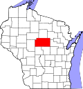
Athens is a village in Marathon County, Wisconsin, United States. The population was 1,059 at the 2020 census. [5] It is part of the Wausau, Wisconsin Metropolitan Statistical Area.
Athens is located at 45°1′58″N90°4′35″W / 45.03278°N 90.07639°W (45.032641, -90.076442). [6] Athens is almost halfway between the Equator and North Pole, as well as almost halfway between the Prime Meridian and 180th meridian. The Athens area is primarily agricultural with a small industrial park on the south side of the village limits.
According to the United States Census Bureau, the village has a total area of 2.46 square miles (6.37 km2), all of it land. [7]
Census | Pop. | Note | %± |
---|---|---|---|
1910 | 904 | — | |
1920 | 940 | 4.0% | |
1930 | 936 | −0.4% | |
1940 | 856 | −8.5% | |
1950 | 823 | −3.9% | |
1960 | 770 | −6.4% | |
1970 | 856 | 11.2% | |
1980 | 988 | 15.4% | |
1990 | 951 | −3.7% | |
2000 | 1,095 | 15.1% | |
2010 | 1,105 | 0.9% | |
2020 | 1,059 | −4.2% | |
U.S. Decennial Census [8] |
As of the census [3] of 2010, there were 1,105 people, 471 households, and 298 families living in the village. The population density was 449.2 inhabitants per square mile (173.4/km2). There were 503 housing units at an average density of 204.5 per square mile (79.0/km2). The racial makeup of the village was 96.2% White, 0.2% African American, 0.2% Native American, 0.2% Asian, 2.4% from other races, and 0.8% from two or more races. Hispanic or Latino of any race were 4.9% of the population.
There were 471 households, of which 30.1% had children under the age of 18 living with them, 50.7% were married couples living together, 8.1% had a female householder with no husband present, 4.5% had a male householder with no wife present, and 36.7% were non-families. 30.1% of all households were made up of individuals, and 14.4% had someone living alone who was 65 years of age or older. The average household size was 2.35 and the average family size was 2.96.
The median age in the village was 39.5 years. 24.7% of residents were under the age of 18; 7.6% were between the ages of 18 and 24; 25.7% were from 25 to 44; 24.3% were from 45 to 64; and 17.7% were 65 years of age or older. The gender makeup of the village was 51.0% male and 49.0% female.
At the 2000 census, [4] there were 1,095 people, 443 households and 299 families living in the village. The population density was 448.2 people per square mile (173.3/km2). There were 469 housing units at an average density of 192.0 per square mile (74.2/km2). The racial makeup of the village was 98.72% White, 0.09% Native American, 0.55% from other races, and 0.64% from two or more races. Hispanic or Latino of any race were 2.10% of the population.
There were 443 households, of which 33.4% had children under the age of 18 living with them, 56.9% were married couples living together, 7.0% had a female householder with no husband present, and 32.5% were non-families. 29.1% of all households were made up of individuals, and 16.9% had someone living alone who was 65 years of age or older. The average household size was 2.47 and the average family size was 3.08.
Age distribution was 26.8% under the age of 18, 8.5% from 18 to 24, 27.2% from 25 to 44, 19.3% from 45 to 64, and 18.3% who were 65 years of age or older. The median age was 36 years. For every 100 females, there were 93.8 males. For every 100 females age 18 and over, there were 94.2 males.
The median household income was $39,286, and the median family income was $52,727. Males had a median income of $30,956 versus $22,167 for females. The per capita income for the village was $17,076. About 1.3% of families and 4.5% of the population were below the poverty line, including 0.7% of those under age 18 and 12.1% of those age 65 or over.
The Athens Library is part of the Marathon County Public Library (MCPL) and the Wisconsin Valley Library Service, a regional library system. [9] The library began in the early 1900s as a small collection of books in the Bloczynski Hotel. In 1926, the Athens Women's Club assumed management of the library, moving the collection to the Athens Bank. [10] The library moved again in 1941, to the Community Hall. In 1947, the Athens Library joined the Marathon County Library. In 1973, when the Marathon County Library and Wausau Public Library merged to form the Marathon County Public Library, the Athens Library became a branch of the MCPL. [10]
The Athens School District is made up of three schools: Athens Elementary School, Athens Middle School, and Athens High School. The middle and high schools share the same building. The Athens School District belongs to the Marawood Conference. Its mascot is the Fighting Bluejay. There are two parochial schools in the community, Trinity Lutheran and St. Anthony's Catholic School.
Marathon County is a county located in the U.S. state of Wisconsin. As of the 2020 census, the population was 138,013. Its county seat is Wausau. It was founded in 1850, created from a portion of Portage County. At that time the county stretched to the northern border with the Upper Peninsula of Michigan. It is named after the battlefield at Marathon, Greece.
Circle is a census-designated place (CDP) in Yukon-Koyukuk Census Area, Alaska, United States. At the 2020 census the population was 91, down from 104 in 2010.
Glouster is a village in Trimble Township, Athens County, Ohio, United States. The population was 1,659 at the 2020 census. It is close to Burr Oak State Park.
Edgar is a village in Marathon County, Wisconsin, United States. It is part of the Wausau, Wisconsin Metropolitan Statistical Area. The population was 1,479 at the 2010 census. Edgar has maintained Tree City USA standing since 1995.
Fenwood is a village in Marathon County, Wisconsin, United States. It is part of the Wausau, Wisconsin Metropolitan Statistical Area. The population was 152 at the 2010 census.
Hatley is a village in Marathon County, Wisconsin, United States. It is part of the Wausau, Wisconsin Metropolitan Statistical Area. The population was 574 at the 2010 census.
Maine is an incorporated village in Marathon County, Wisconsin, United States. It is part of the Wausau, Wisconsin Metropolitan Statistical Area. The population was 2,337 at the 2010 census. The unincorporated communities of Mount View and Taegesville are located partially in the town.
Marathon City is a village in Marathon County, Wisconsin, United States. It is part of the Wausau, Wisconsin Metropolitan Statistical Area. The population was 1,524 at the 2010 census. The village was incorporated from a part of the original area of the town of Marathon. The village dates back to 1856. The name of the village commemorates the Battle of Marathon.
Rothschild is a village in Marathon County, Wisconsin, United States. It is part of the Wausau, Wisconsin Metropolitan Statistical Area. The population was 5,567 at the 2020 census. Rothschild is the northern terminus of Interstate 39, which starts in Normal, Illinois.
Stratford is a village in Marathon County, Wisconsin, United States. It is part of the Wausau, Wisconsin Metropolitan Statistical Area. The population was 1,578 at the 2010 census.
Stetsonville is a village in Taylor County, Wisconsin, United States. The population was 541 at the 2010 census.
Abbotsford is a city in Clark and Marathon counties in the U.S. state of Wisconsin. The population was 2,275 at the 2020 census. Of this, 1,665 were in Clark County, and 610 were in Marathon County. Abbotsford is nicknamed "Wisconsin's First City" due to its alphabetical place on a list of Wisconsin cities.
Dorchester is a village in Clark and Marathon counties in the U.S. state of Wisconsin, along the 45th parallel. It is part of the Wausau, Wisconsin Metropolitan Statistical Area. The population was 876 at the 2010 census. Of this, 871 were in Clark County, and only 5 were in Marathon County.
Viola is a village in Richland (mostly) and Vernon counties in the U.S. state of Wisconsin. The population was 699 at the 2010 census. Of this, 477 were in Richland County, and 222 were in Vernon County.
Birnamwood is a village in Marathon and Shawano counties in the U.S. state of Wisconsin. It is part of the Wausau, Wisconsin Metropolitan Statistical Area. The population was 818 at the 2010 census. Of this, 802 were in Shawano County, and 16 were in Marathon County. The village is located mostly within the town of Birnamwood in Shawano County; only a small portion extends into the town of Norrie in adjacent Marathon County.
Unity is a village in Clark and Marathon counties in the U.S. state of Wisconsin. It is part of the Wausau, Wisconsin Metropolitan Statistical Area. The population was 343 at the 2010 census. Of this, 204 were in Marathon County, and 139 were in Clark County. The village is located in northeastern town of Unity in Clark County and northwestern town of Brighton in Marathon County.
Colfax is a village in Dunn County, Wisconsin, United States. The population was 1,158 at the 2010 census. The village is surrounded by the Town of Colfax.
The Town of Spencer is located in Marathon County, Wisconsin, United States. It is part of the Wausau, WI Metropolitan Statistical Area. The population was 1,581 at the 2010 census. The village of Spencer is located in the northeastern part of the town.The unincorporated community of Mann also is located in the town.
Spencer is a village in Marathon County, Wisconsin. It is part of the Wausau, Wisconsin Metropolitan Statistical Area. The population was 1,925 at the 2010 census.
Pound is a village in Marinette County, Wisconsin, United States. The population was 377 at the 2010 census. The village is located within the Town of Pound. Pound is part of the Marinette, WI– MI Micropolitan Statistical Area.