
Cumberland County is a county in the Canadian province of Nova Scotia.

Gloucester County is located in the northeastern corner of New Brunswick, Canada. Fishing, mining and forestry are the major industries in the county. The eastern section of the county is known for its Acadian culture. The county is named for Princess Mary, Duchess of Gloucester and Edinburgh.

Kent County is located in east-central New Brunswick, Canada. The county features a unique blend of cultures including Mi'kmaq, Acadian, and English. Some larger tourist attractions include the dune de Bouctouche, Kouchibouguac National Park, and Bonar Law Commons.

Kings County is located in southern New Brunswick, Canada. Its historical shire town is Hampton and it was named as an expression of loyalty to the British Crown. Both the Saint John and Kennebecasis rivers pass through the county.

Queens County is located in central New Brunswick, Canada. The county shire town is the village of Gagetown. The county was named as an expression of loyalty to the Crown and to commemorate a group of earlier settlers originally from Queens County, New York.

Restigouche County is located in north-central New Brunswick, Canada. The county is named for the Restigouche River which flows through the county and is famous for its salmon pools, which have attracted wealthy American and Canadian tourists to the region's summer colonies for decades. Forestry dominates the local economy.

Westmorland County is a county in New Brunswick, a province of Canada. It is in the south-eastern part of the province. It contains the fast-growing commercial centre of Moncton and its northern and eastern suburbs. Also located in the county are the university town of Sackville and the local tourist destination of Shediac.

York County is located in west-central New Brunswick, Canada. The county contains the provincial capital, Fredericton. Outside the city, farming and forestry are two major industries in the county, which is bisected by the Saint John River. The Southwest Miramichi River flows through the northern section of the county.
New Maryland is an affluent suburban bedroom community of Fredericton in central New Brunswick, Canada; located directly south of Fredericton, south of Route 2 and Route 101. As of 2021, the population was 4,153, which means it is large enough to become a "town". New Maryland having the highest average household net worth in the province of New Brunswick is one of the wealthiest communities in New Brunswick. New Maryland has a median household income of over $116,000, the highest of any municipality in the province and across Atlantic Canada and ranks among the top 5 across Canada.
Balmoral is a former village in Restigouche County, New Brunswick, Canada. It held village status prior to 2023 and is now part of the village of Bois-Joli. It is approximately 10 kilometres south of Dalhousie. Balmoral also contains the neighbourhoods of Blair Athol, Saint-Maure, Selwood, and Upper Balmoral.
Kedgwick is a Canadian incorporated rural community in northern New Brunswick, Canada. On 1 January 2023, Kedgwick annexed a large area including the local service districts of St. Jean Baptiste – Menneval and White's Brook, with parts of two others; revised census figures have not been released.

Saint-André is community in Saint-André Parish, Madawaska County, New Brunswick, Canada. It was part of an eponymous rural community prior to 2023; the most recent census data is for the rural community. It is now part of the town of Grand Falls.
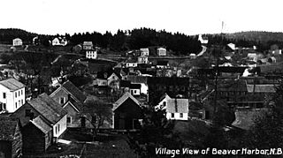
Beaver Harbour is a community on the Fundy shore of New Brunswick, Canada.
Tabusintac is an unincorporated community in Northumberland County in the Canadian province of New Brunswick. It is situated on the north side of Miramichi Bay.
Mann Mountain Settlement is an unincorporated community in Restigouche County, New Brunswick, Canada.
Dalhousie Junction is a rural community and former local service district in Restigouche County, New Brunswick, Canada. As of 2016, its population is 396 people.
McLeods was a local service district in Restigouche County, New Brunswick, Canada. In 2016, it had a population of 372 people.
Whites Brook is an unincorporated community in Restigouche County, New Brunswick, Canada.
LaPlante is a settlement in New Brunswick.
Village-Blanchard is an unincorporated community in New Brunswick, Canada. It was called Blanchard Settlement until 2010.
