Merriman, Nebraska

Last updated

Merriman, Nebraska
Merriman, Nebraska from S 1.JPG
Merriman, seen from the south along Nebraska Highway 61
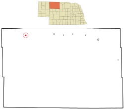
Cherry County Nebraska Incorporated and Unincorporated areas Merriman Highlighted.svg
Location of Merriman, Nebraska
Coordinates: 42°55′23″N101°41′59″W / 42.92306°N 101.69972°W / 42.92306; -101.69972
Country United States
State Nebraska
County Cherry
Area
[1]
  Total1.03 sq mi (2.66 km2)
  Land1.03 sq mi (2.66 km2)
  Water0.00 sq mi (0.00 km2)
Elevation
[2]
3,261 ft (994 m)
Population
 (2020)
  Total87
  Density84.71/sq mi (32.71/km2)
Time zone UTC-7 (Mountain (MST))
  Summer (DST) UTC-6 (MDT)
ZIP code
69218
Area code 308
FIPS code 31-31815 [3]
GNIS feature ID2399320 [2]

Merriman is a village in Cherry County, Nebraska. The population was 128 at the time of the 2010 census.

Contents

History

Merriman was established in 1885 when the Fremont, Elkhorn and Missouri Valley Railroad was extended to that point. [4] It was named for J. Merriman, a railroad official. [5]

Demographics

Historical population
CensusPop.Note
1910 254
1920 34636.2%
1930 3624.6%
1940 321−11.3%
1950 260−19.0%
1960 2859.6%
1970 172−39.6%
1980 159−7.6%
1990 151−5.0%
2000 118−21.9%
2010 1288.5%
2020 87−32.0%
U.S. Decennial Census [6]

2010 census

As of the census [7] of 2010, there were 128 people, 58 households, and 36 families living in the village. The population density was 124.3 inhabitants per square mile (48.0/km2). There were 68 housing units at an average density of 66.0 per square mile (25.5/km2). The racial makeup of the village was 87.5% White, 1.6% African American, 6.3% Native American, and 4.7% from two or more races. Hispanic or Latino of any race were 0.8% of the population.

There were 58 households, of which 24.1% had children under the age of 18 living with them, 51.7% were married couples living together, 5.2% had a female householder with no husband present, 5.2% had a male householder with no wife present, and 37.9% were non-families. 34.5% of all households were made up of individuals, and 27.6% had someone living alone who was 65 years of age or older. The average household size was 2.21 and the average family size was 2.78.

The median age in the village was 51 years. 22.7% of residents were under the age of 18; 0.8% were between the ages of 18 and 24; 18.8% were from 25 to 44; 26.6% were from 45 to 64; and 31.3% were 65 years of age or older. The gender makeup of the village was 50.8% male and 49.2% female.

2000 census

At the 2000 census, [3] there were 118 people, 51 households and 31 families living in the village. The population density was 115.0 inhabitants per square mile (44.4/km2). There were 69 housing units at an average density of 67.3 per square mile (26.0/km2). The racial makeup of the village was 93.22% White, 3.39% Native American, and 3.39% from two or more races.

There were 51 households, of which 29.4% had children under the age of 18 living with them, 51.0% were married couples living together, 5.9% had a female householder with no husband present, and 39.2% were non-families. 35.3% of all households were made up of individuals, and 19.6% had someone living alone who was 65 years of age or older. The average household size was 2.31 and the average family size was 3.00.

27.1% of the population were under the age of 18, 5.1% from 18 to 24, 20.3% from 25 to 44, 25.4% from 45 to 64, and 22.0% who were 65 years of age or older. The median age was 42 years. For every 100 females, there were 93.4 males. For every 100 females age 18 and over, there were 95.5 males.

The median household income was $19,250 and the median family income was $23,750. Males had a median income of $21,875 compared with $13,750 for females. The per capita income for the village was $10,736. There were 26.7% of families and 30.1% of the population living below the poverty line, including 31.4% of under eighteens and 20.0% of those over 64.

Geography

According to the United States Census Bureau, the village has a total area of 1.03 square miles (2.67 km2), all land. [8]

Climate

The area is characterized by humid continental climate which typically has a large seasonal temperature difference, with warm to hot (and often humid) summers and cold (sometimes severely cold) winters. Precipitation is relatively well distributed year-round in many areas with this climate, while others may see a marked reduction in wintry precipitation and even a wintertime drought. The Köppen Climate Classification subtype for this climate is "Dfa" (Hot Summer Continental Climate). [9]

Climate data for Merriman
MonthJanFebMarAprMayJunJulAugSepOctNovDecYear
Average high °C (°F)1
(33)
4
(39)
8
(46)
15
(59)
21
(69)
27
(80)
31
(87)
30
(86)
25
(77)
18
(64)
8
(46)
3
(37)
15
(59)
Average low °C (°F)−12
(10)
−9
(15)
−6
(21)
0
(32)
5
(41)
11
(51)
14
(57)
13
(55)
7
(44)
1
(33)
−5
(23)
−10
(14)
0
(32)
Average precipitation mm (inches)13
(0.5)
13
(0.5)
23
(0.9)
48
(1.9)
76
(3)
84
(3.3)
69
(2.7)
48
(1.9)
36
(1.4)
28
(1.1)
15
(0.6)
10
(0.4)
460
(18)
Average precipitation days23349776422251
Source: Weatherbase [10]

Notable people

Related Research Articles

<span class="mw-page-title-main">Kachina Village, Arizona</span> CDP in Coconino County, Arizona

Kachina Village is a census-designated place (CDP) in Coconino County, Arizona, United States. The population was 2,622 at the 2010 census. Kachina Village is primarily a bedroom community for Flagstaff.

<span class="mw-page-title-main">Highland Park, Florida</span> Village in Florida, United States

Highland Park is a village in Polk County, Florida, United States. The population was 230 at the 2010 census. It is part of the Lakeland–Winter Haven Metropolitan Statistical Area.

<span class="mw-page-title-main">Central Lake, Michigan</span> Village in Michigan, United States

Central Lake is a village in Antrim County in the U.S. state of Michigan. The population was 952 at the 2010 census. The village is located within Central Lake Township.

<span class="mw-page-title-main">Beulah, Michigan</span> Village in Michigan, United States

Beulah is a village in the U.S. state of Michigan. It is the county seat of Benzie County, and is located within Benzonia Township. The village had a population of 313 at the 2020 census. The village sits at the southeast end of Crystal Lake, and is immediately north of the village of Benzonia.

<span class="mw-page-title-main">Custer, Michigan</span> Village in Michigan, United States

Custer is a village in Mason County in the U.S. state of Michigan. The population was 285 at the 2010 census. The village is located within Custer Township.

<span class="mw-page-title-main">Dundee, Michigan</span> Village in Michigan, United States

Dundee is a village in Monroe County in the U.S. state of Michigan. The population was 5,323 at the 2020 census. The village is within Dundee Township and is served by Dundee Community Schools.

<span class="mw-page-title-main">Ontonagon, Michigan</span> Village in Michigan, United States

Ontonagon is a village in the Upper Peninsula of the U.S. state of Michigan. The population was 1,285 at the 2020 census. It is the county seat of Ontonagon County, and is the only incorporated place within the county.

<span class="mw-page-title-main">Vanderbilt, Michigan</span> Village in Michigan, United States

Vanderbilt is a village in Otsego County in the U.S. state of Michigan. The population was 498 at the 2020 census. The village is located within Corwith Township.

<span class="mw-page-title-main">Ottertail, Minnesota</span> City in Minnesota, United States

Ottertail is a city in Otter Tail County, Minnesota, United States. The population was 629 at the 2020 census.

<span class="mw-page-title-main">Anselmo, Nebraska</span> Village in Nebraska, United States

Anselmo is a village in Custer County, Nebraska, United States. The population was 145 at the 2010 census.

<span class="mw-page-title-main">Mead, Nebraska</span> Village in Saunders County, Nebraska, United States

Mead is a village in Saunders County, Nebraska, United States. The population was 617 at the 2020 census.

<span class="mw-page-title-main">Adamsville, Ohio</span> Village in Ohio, United States

Adamsville is a village in Muskingum County, Ohio, United States. The population was 140 at the 2020 census. It is part of the Zanesville micropolitan area.

<span class="mw-page-title-main">Burnsville, West Virginia</span> Town in West Virginia, United States

Burnsville is a town in Braxton County, West Virginia, United States, at the confluence of the Little Kanawha River and Saltlick Creek. The population was 401 at the 2020 census. Burnsville was incorporated in 1902 by the Circuit Court and named for Captain John Burns who operated the first sawmill in that section of the state and who established the town shortly after the close of the American Civil War. It was named "All West Virginia City" in 1976.

<span class="mw-page-title-main">Beech Bottom, West Virginia</span> Village in West Virginia, United States

Beech Bottom is a village in Brooke County, West Virginia, United States, situated along the Ohio River. The population was 523 at the 2010 census. It is part of the Weirton–Steubenville metropolitan area.

<span class="mw-page-title-main">Man, West Virginia</span> Town in West Virginia, United States

Man is a town in Logan County, West Virginia, United States. The population was 759 at the 2010 census. The town is located along the Guyandotte River at the mouth of Buffalo Creek, which was the site of the 1972 Buffalo Creek Flood following a dam collapse. The name of the town reportedly derives from the last syllable of the surname of Ulysses Hinchman, who was a member of the House of Delegates from Logan County between 1866 and 1869.

<span class="mw-page-title-main">Iaeger, West Virginia</span> Town in West Virginia, United States

Iaeger is a town in McDowell County, West Virginia, United States. The population was 257 at the 2020 census.

<span class="mw-page-title-main">Granville, West Virginia</span> Town in West Virginia

Granville is a town in Monongalia County, West Virginia, United States. The population was 1,355 at the 2020 census. It is included in the Morgantown metropolitan area.

<span class="mw-page-title-main">Bowler, Wisconsin</span> Village in Wisconsin, United States

Bowler is a village in Shawano County, Wisconsin, United States. The population was 302 at the 2010 census.

<span class="mw-page-title-main">Arlington, Wisconsin</span> Village in Wisconsin, United States

Arlington is a village in Columbia County, Wisconsin, United States. The population was 819 at the 2010 census. The village is located within the Town of Arlington. It is part of the Madison Metropolitan Statistical Area.

<span class="mw-page-title-main">Fairchild, Wisconsin</span> Village in Wisconsin, United States

Fairchild is a village in Eau Claire County, Wisconsin, United States. The population was 550 at the 2010 census. The village is located within the Town of Fairchild.

References

  1. "ArcGIS REST Services Directory". United States Census Bureau. Retrieved September 18, 2022.
  2. 1 2 U.S. Geological Survey Geographic Names Information System: Merriman, Nebraska
  3. 1 2 "U.S. Census website". United States Census Bureau . Retrieved January 31, 2008.
  4. "Merriman, Cherry County". Center for Advanced Land Management Information Technologies. University of Nebraska. Retrieved August 2, 2014.
  5. Chicago and North Western Railway Company (1908). A History of the Origin of the Place Names Connected with the Chicago & North Western and Chicago, St. Paul, Minneapolis & Omaha Railways. p. 101.
  6. "Census of Population and Housing". Census.gov. Retrieved June 4, 2015.
  7. "U.S. Census website". United States Census Bureau . Retrieved June 24, 2012.
  8. "US Gazetteer files 2010". United States Census Bureau. Archived from the original on January 25, 2012. Retrieved June 24, 2012.
  9. Climate Summary for Merriman
  10. "Weatherbase.com". Weatherbase. 2013. Retrieved on June 27, 2013.