The Dwight D. Eisenhower National System of Interstate and Defense Highways, commonly known as the Interstate Highway System, is a network of controlled-access highways that forms part of the National Highway System in the United States. The system is named for President Dwight D. Eisenhower, who championed its formation. Construction was authorized by the Federal Aid Highway Act of 1956, and the original portion was completed 35 years later, although some urban routes were cancelled and never built. The network has since been extended. In 2016, it had a total length of 48,181 miles (77,540 km). As of 2016, about one-quarter of all vehicle miles driven in the country use the Interstate system. In 2006, the cost of construction was estimated at about $425 billion.

U.S. Route 66, also known as the Will Rogers Highway, the Main Street of America or the Mother Road, was one of the original highways in the U.S. Highway System. US 66 was established on November 11, 1926, with road signs erected the following year. The highway, which became one of the most famous roads in the United States, originally ran from Chicago, Illinois, through Missouri, Kansas, Oklahoma, Texas, New Mexico, and Arizona before ending in Santa Monica in Los Angeles County, California, covering a total of 2,448 miles (3,940 km). It was recognized in popular culture by both the hit song "(Get Your Kicks on) Route 66" and the Route 66 television show in the 1960s. In John Steinbeck's classic American novel, The Grapes of Wrath (1939), the road, "Highway 66", was turned into a powerful symbol of escape and loss.

Interstate 15 (I-15) is a major Interstate Highway in the western United States. I-15 begins near the Mexico–US border in San Diego County and stretches north to Alberta, Canada, passing through the states of California, Nevada, Arizona, Utah, Idaho, and Montana. The interstate serves the cities of San Diego, Las Vegas, St. George, Provo, Salt Lake City, Ogden, Pocatello, Idaho Falls, Butte, Helena, and Great Falls. It also passes close to the urban areas of Orange County, California and Los Angeles County, California. The stretches of I-15 in Idaho, Utah, and Arizona have been designated as the "Veterans Memorial Highway". The southern end is at a junction with I-8 and State Route 15 in San Diego, and the northern end is at a connection with Alberta Highway 4 at the Sweetgrass–Coutts Border Crossing.
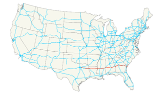
U.S. Route 80 (US 80) is an east-west United States Numbered Highway, much of which was once part of the early auto trail known as the Dixie Overland Highway. As the "0" in the route number indicates, it was originally a cross-country route, from the Pacific Ocean to the Atlantic Ocean. Its original western terminus was in San Diego, California. However, the entire segment west of Dallas, Texas, has been decommissioned in favor of various Interstate Highways and state highways. Currently, the highway's western terminus is at an interchange with Interstate 30 (I-30) on the Dallas–Mesquite, Texas city line. The highway's eastern terminus is in Tybee Island, Georgia, at the intersection of Butler Avenue, Inlet Avenue, and Tybrisa Street, near the Atlantic Ocean.
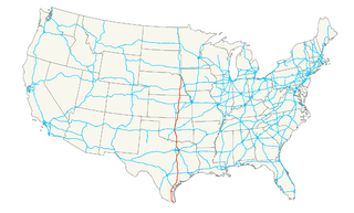
U.S. Route 77 is a major north–south United States highway which extends for 1305 miles in the central United States. As of 2005, the highway's northern terminus is in Sioux City, Iowa, at an interchange with Interstate 29. Its southern terminus is in Brownsville, Texas, at Veteran's International Bridge on the U.S.-Mexico border, where it connects with both Mexican Federal Highway 101 and Mexican Federal Highway 180.

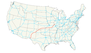
U.S. Route 59 is a north–south United States highway. A latecomer to the U.S. numbered route system, US 59 is now a border-to-border route, part of NAFTA Corridor Highway System. It parallels U.S. Route 75 for nearly its entire route, never much more than 100 miles (160 km) away, until it veers southwest in Houston, Texas. Its number is out of place since US 59 is either concurrent with or entirely west of U.S. Route 71.
U.S. Route 54 is an east–west United States highway that runs northeast-southwest for 1,197 miles (2,115 km) from Griggsville, Illinois to El Paso, Texas. It enters and leaves Texas twice. The Union Pacific Railroad's Tucumcari Line runs parallel to US-54 from El Paso to Pratt, Kansas, which comprises about two-thirds of the route.
Federal Highway 40, also called the Carretera Interoceánica, is a road beginning at Reynosa, Tamaulipas, just west of the Port of Brownsville, Texas, and ending at Fed. 15 in Villa Unión, Sinaloa, near Mazatlán and the Pacific coast. It is called Interoceanic as, once finished, the cities of Matamoros, Tamaulipas, on the Gulf of Mexico and Mazatlán on the Pacific Ocean will be linked.

State Highway 128 is a state highway in Andrews County, Texas.

Tepetlixpa is a village and municipality in Mexico State in Mexico. The municipality covers an area of 46.68 km².

The Circuito Exterior Mexiquense literally, "Outer Loop of the State of Mexico", also known as the Vía Mexiquense or "'Autopista mexiquense'" is a series of toll roads constructed between 2006 and 2011 by the State of Mexico government, providing an option for motorists to skirt the edge of Greater Mexico City when driving between areas in the State of Mexico to the northwest of Mexico City, northeast of Mexico City and east of Mexico City. Portions carry the Mexican Federal Highway 57D designation, and others carry the State of Mexico State Highway 5D designation.
Federal Highway 136D is a toll highway connecting the communities of Peñón and Texcoco in the State of Mexico. The 16.5-kilometre (10.3 mi) road is operated by Concesionaria PAC, S.A. de C.V. and Operadora Metropolitana de Carreteras, S. A. de C. V., which charge cars 42 pesos to travel the full length of the road.
Federal Highway 95D is a toll highway connecting Mexico City to Acapulco, Guerrero. Highway 95D is among the most important toll roads in the country, serving as a backbone for traffic out of Mexico City toward Morelos and tourist destinations in Guerrero.
Federal Highway 160D is a toll highway primarily located in Morelos. It functions as a spur of Mexican Federal Highway 95D to the city of Cuautla. The road is operated by Caminos y Puentes Federales, which charges a toll of 54 pesos per car to travel Highway 160D.
Federal Highway 150D is a toll highway connecting Mexico City to Veracruz City via Puebla City and Córdoba. It serves as one of the backbones of Mexico's toll road system. The road is primarily operated by Caminos y Puentes Federales, which charges cars 520 pesos to travel Highway 150D, with one segment in the Puebla metropolitan area built and maintained by OHL and PINFRA.
Federal Highway 145D is a toll highway in the state of Veracruz. It connects southern Veracruz to Mexican Federal Highway 150D, continuing the other road's east-west trajectory. The road is operated by Caminos y Puentes Federales, who charges a toll of 183 pesos per car to travel Highway 145D.
Federal Highway 15D is the name for toll highways paralleling Federal Highway 15. The toll segments of Highway 15D include some of the most significant highways in the country along the Nogales-Mexico City corridor. The highway is the southern terminus of the CANAMEX Corridor, a trade corridor that stretches from Mexico north across the United States to the Canadian province of Alberta.
Federal Highway 57D (Fed. 57D) is a tolled (cuota) part of the federal highways corridor of the paralleling Fed. 57. Eight separate tolled segments exist of Fed. 57D between Mexico City and Allende, Coahuila; a ninth is part-federal and part-state.