Federal Highway 125(Carretera Federal No. 125) is a Federal Highway of Mexico that runs from Veracruz south across the Sierra Madre Oriental to just north of the Pacific Ocean in Oaxaca. Federal Highway 125 is split into three segments: the first segment travels from Conejos, Veracruz in the north to Fortín de las Flores in the south. The second segment travels from Tehuacán, Puebla in the north to Huajuapan de León, Oaxaca in the south. The third segment travels from Yucudaa, Oaxaca to Pinotepa Nacional, Oaxaca.
Federal Highway 35 is a free part of the federal highways corridors of Mexico, that is in two separate improved segments.
Federal Highway 120 connects La Placita de Morelos, Michoacán, to Mexican Federal Highway 85 in San Luis Potosí. Federal Highway 120 is split into two segments: the first segment runs from Xilitla, San Luis Potosí in the north to San José, Michoacán in the south. The second segment travels from Quiroga, Michoacán in the north to Tepalcatepec in the south.
Federal Highway 90 connects Irapuato, Guanajuato to Zapotlanejo, Jalisco near Guadalajara. Federal Highway 90 has two main segments.
Federal Highway 49 (Fed. 49) is a free (libre) part of the federal highways corridors of Mexico. The highway runs northwest-southeast in the western regions of the Mexican Plateau.
Federal Highway 51 (Fed. 51) is a free (libre) part of the federal highways corridors of Mexico. Fed. 51 has two segments: the first segment run from Ojuelos de Jalisco to Maravatío, Michoacán. The length of the first segment is 309.41 km. The second segment runs from Zitácuaro, Michoacán to Iguala, Guerrero. The length of the second segment is 399.05 km.
Federal Highway 93 (Fed. 93) is a free (libre) part of the federal highways corridors of Mexico.
Federal Highway 105 is a Federal Highway of Mexico. The highway travels from Tempoal de Sánchez, Veracruz in the north to Pachuca, Hidalgo in the south.
Federal Highway 115 is a Federal Highway of Mexico. The highway travels from Ixtapaluca, State of Mexico in the north to Izúcar de Matamoros, Puebla in the south. Federal Highway 115 is co-signed with Mexican Federal Highway 160 from Izúcar de Matamoros to north of Cuautla in Cuautlixco, Morelos.
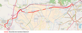
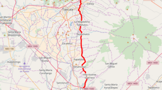
Federal Highway 117 is a Federal Highway of Mexico. The highway travels from Tlatempa, Tlaxcala in the north to San Martín Texmelucan, Puebla to the south.
Federal Highway 121 is a Federal Highway of Mexico. The highway travels from Apizaco, Tlaxcala in the north to Puebla City, Puebla in the south.
Federal Highway 127 is a Federal Highway of Mexico. Federal Highway 127 is split into two segments: the first segment travels from Pánuco, Veracruz in the north to Tihuatlán in the south. The second segment travels from Poza Rica in the north to Martínez de la Torre in the south.
Federal Highway 129 is a Federal Highway of Mexico. The highway travels from Nautla, Veracruz in the northeast to Amozoc de Mota, Puebla in the southwest.
Federal Highway 131 is a Federal Highway of Mexico. Federal Highway 131 is split into two segments: the first segment travels from Teziutlán, Puebla in the north to Perote, Veracruz in the south. The second segment, entirely within Oaxaca, travels from south of Oaxaca de Juárez in the north to Puerto Escondido in the south.

Federal Highway 136 is a Federal Highway of Mexico. The highway travels from Zacatepec, Puebla in the east to Los Reyes Acaquilpan, State of Mexico in the west.
Federal Highway 140 is a Federal Highway of Mexico. The highway travels from Veracruz, Veracruz in the east to Tepeaca, Puebla in the west.

Federal Highway 150 is a Federal Highway of Mexico. The highway travels from Mexico City in the west to Veracruz, Veracruz in the east. Federal Highway 150 is one of five Mexican Federal Highways that terminate in Mexico's capital city.
Federal Highway 160 is a Federal Highway of Mexico. The highway travels from Cuernavaca, Morelos in the west to Izúcar de Matamoros, Puebla in the east. Federal Highway 160 is co-signed with Mexican Federal Highway 115 from Izúcar de Matamoros to north of Cuautla in Cuautlixco, Morelos.
Federal Highway 184 is a Federal Highway of Mexico. The highway travels from Felipe Carrillo Puerto, Quintana Roo in the southeast to Muna, Yucatán in the northwest.
Federal Highway 190 is a Federal Highway of Mexico. Federal Highway 190 is split into two segments: the first segment travels from Tehuantepec, Oaxaca in the east to Puebla City, Puebla in the west. The second segment travels from La Ventosa, Juchitán de Zaragoza Municipality, Oaxaca in the west eastward to Ciudad Cuauhtémoc, Chiapas. Fed. Highway 190's eastern segment ends at a Guatemala-Mexico border crossing at Ciudad Cuauhtémoc. The Pan-American Highway route in southern Mexico continues into Guatemala as Central American Highway 1 (CA-1).

