Mission Viejo is a commuter city located within Orange County, California, United States in the Saddleback Valley. Mission Viejo is considered one of the largest master-planned communities ever built under a single project in the United States and is rivaled only by Highlands Ranch, Colorado in its size. Its population as of 2014 was estimated at 96,346.

Rancho Santa Margarita is a city in Orange County, California, United States. One of Orange County's youngest cities, Rancho Santa Margarita is a master-planned community. The population was 47,853 at the 2010 census, up from 47,214 at the 2000 census. Although it is named for Rancho Santa Margarita y Las Flores, which was in San Diego County, the city limits fall within the borders of Rancho Mission Viejo. At 20 characters long, it is the longest city name in California.
Rancho Viejo is a town in Cameron County, Texas, United States. The population was 2,437 at the 2010 census. The town is named from a ranch in that area named "Rancho Viejo". This ranch was owned by Blas María de la Garza Falcón, whose name was given to a nearby dam, Falcon Dam.

State Route 238 is a north–south highway in the U.S. state of California. The route is a divided multilane surface highway in the southeastern part of the San Francisco Bay Area. SR 238 connects Interstate 580 in Hayward and Interstate 680 in Fremont.
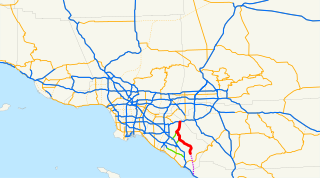
State Route 241 is a tollway located entirely in Orange County, California, in the Greater Los Angeles urban area. For its entire length, Route 241 is a toll road. Its northern half is part of the Eastern Transportation Corridor while its southern half is part of the Foothill Transportation Corridor. The highway currently runs from Ladera Ranch to Yorba Linda. State Route 241 connects with State Route 133, State Route 261, and State Route 91.
Rancho Mission Viejo is an active 23,000 acres (9,300 ha) ranch and farm, habitat reserve, and community in the unincorporated areas of South Orange County, California. Rancho Mission Viejo originated as a series of land grants to John Forster in 1845. The remaining part of Rancho Mission Viejo consists of a nearly 17,000-acre (6,900 ha) nature reserve and multiple residential communities slated to open in phases between 2010 and 2030. As of 2017, the Sendero village and the Gavilan senior housing developments have been completed. The larger Esencia village is currently under construction with a K-8 school to be opened in fall of 2018. Sendero Marketplace, a shopping center built as part of the community is also under construction.
Nueva Ciudad Guerrero is a city in the Mexican state of Tamaulipas. It lies on the banks of the Rio Grande / Río Bravo, near the US–Mexico border, opposite to Falcon Heights, Texas. The Lake Falcon Dam International Crossing connects Falcon Heights with Nueva Ciudad Guerrero.
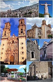
Federal Highway 95 connects Mexico City to Acapulco, Guerrero. The Autopista del Sol is a tolled alternative, which bypasses several towns of the state of Guerrero, including the city Iguala, and thus reduces from 8 hours to almost 3.5 hours the time required to get to Acapulco from Mexico city.
Federal Highway 51 (Fed. 51) is a free (libre) part of the federal highways corridors of Mexico. Fed. 51 has two segments: the first segment run from Ojuelos de Jalisco to Maravatío, Michoacán. The length of the first segment is 309.41 km. The second segment runs from Zitácuaro, Michoacán to Iguala, Guerrero. The length of the second segment is 399.05 km.
Federal Highway 93 (Fed. 93) is a free (libre) part of the federal highways corridors of Mexico.

San Luis Acatlán is one of the 81 municipalities of Guerrero, in south-western Mexico. The municipal seat lies at San Luis Acatlán. The municipality covers an area of 704.4 km².

Xochistlahuaca Municipality is one of the 81 municipalities of Guerrero, in south-western Mexico. The municipal seat lies at Xochistlahuaca. The municipality covers an area of 321.1 km².

New Mexico State Road 528 (NM 528) is a 15.3 mi (24.6 km) long state highway in Sandoval County and Bernalillo County, New Mexico. NM 528 is signed as Alameda Blvd. In Rio Rancho, the road is also known as Pat D'Arco Highway, named after former mayor of Rio Rancho Pat D'Arco. It is an L-shaped route signed north-south in Sandoval County and east-west in Bernalillo County.
Rancho San Jacinto Viejo was a 35,503-acre (143.68 km2) Mexican land grant in present-day Riverside County, California given in 1842 by Governor Pro-tem Manuel Jimeno to José Antonio Estudillo. At the time of the US Patent, Rancho San Jacinto Viejo was a part of San Diego County. The County of Riverside was created by the California Legislature in 1893 by taking land from both San Bernardino and San Diego Counties. The grant encompassed present-day Hemet and San Jacinto.
El Camino Viejo a Los Ángeles, also known as El Camino Viejo and the Old Los Angeles Trail, was the oldest north-south trail in the interior of Spanish colonial Las Californias (1769–1822) and Mexican Alta California (1822–1848), present day California. It became a well established inland route, and an alternative to the coastal El Camino Real trail used since the 1770s in the period.

San Emigdio Creek, formerly Arroyo de San Emigdio, is a 33 kilometres (21 mi) northward-flowing stream in western Kern County, central California.
New Mexico State Road 45 is a State Highway in the US state of New Mexico that runs parallel to the Rio Grande from the Pueblo of Isleta, through Albuquerque, and up to the border of Rio Rancho.
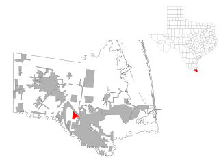
Rancho Viejo is a census-designated place (CDP) in Starr County, Texas, United States. It is a new CDP formed from part of the La Rosita CDP prior to the 2010 census with a population of 228.
Federal Highway 95D is a toll highway connecting Mexico City to Acapulco, Guerrero. Highway 95D is among the most important toll roads in the country, serving as a backbone for traffic out of Mexico City toward Morelos and tourist destinations in Guerrero.
Federal Highway 200D is the toll highways paralleling Fed. 200, and has two separate improved segments of designated roadway. Fed200D in Colima funnels traffic from Manzanillo toward Fed110 to Colima City; the segment in Guerrero serves as a bypass of Tecpan de Galeana.