Federal Highway 125(Carretera Federal No. 125) is a Federal Highway of Mexico that runs from Veracruz south across the Sierra Madre Oriental to just north of the Pacific Ocean in Oaxaca. Federal Highway 125 is split into three segments: the first segment travels from Conejos, Veracruz in the north to Fortín de las Flores in the south. The second segment travels from Tehuacán, Puebla in the north to Huajuapan de León, Oaxaca in the south. The third segment travels from Yucudaa, Oaxaca to Pinotepa Nacional, Oaxaca.
Federal Highway 49 (Fed. 49) is a free (libre) part of the federal highways corridors of Mexico. The highway runs northwest-southeast in the western regions of the Mexican Plateau.
Federal Highway 55 (Fed. 55) is a free (libre) part of the federal highways corridors of Mexico. The highway connects Puerta de Palmillas, Querétaro to the north and Axixintla, Guerrero to the south.
Federal Highway 93 (Fed. 93) is a free (libre) part of the federal highways corridors of Mexico.
Federal Highway 110 is a Federal Highway of Mexico.
Federal Highway 113 is a Federal Highway of Mexico. The highway travels from Mexico City in the north to Oaxtepec, Morelos in the south.
Federal Highway 115 is a Federal Highway of Mexico. The highway travels from Ixtapaluca, State of Mexico in the north to Izúcar de Matamoros, Puebla in the south. Federal Highway 115 is co-signed with Mexican Federal Highway 160 from Izúcar de Matamoros to north of Cuautla in Cuautlixco, Morelos.
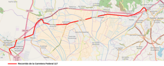
Federal Highway 117 is a Federal Highway of Mexico. The highway travels from Tlatempa, Tlaxcala in the north to San Martín Texmelucan, Puebla to the south.

Federal Highway 119 is a Federal Highway of Mexico. Federal Highway 119 is split into two segments: the first segment travels from Tejocotal, Hidalgo in the north to Apizaco, Tlaxcala in the south. The second segment travels from Tlaxcala City in the north to Puebla City in the south.
Federal Highway 129 is a Federal Highway of Mexico. The highway travels from Nautla, Veracruz in the northeast to Amozoc de Mota, Puebla in the southwest.
Federal Highway 131 is a Federal Highway of Mexico. Federal Highway 131 is split into two segments: the first segment travels from Teziutlán, Puebla in the north to Perote, Veracruz in the south. The second segment, entirely within Oaxaca, travels from south of Oaxaca de Juárez in the north to Puerto Escondido in the south.
Federal Highway 135 is a Federal Highway of Mexico. The highway travels from Tehuacán, Puebla in the north to San Francisco Telixtlahuaca-San Pablo Huitzo, Oaxaca in the south.

Federal Highway 136 is a Federal Highway of Mexico. The highway travels from Zacatepec, Puebla in the east to Los Reyes Acaquilpan, State of Mexico in the west.
Federal Highway 140 is a Federal Highway of Mexico. The highway travels from Veracruz, Veracruz in the east to Tepeaca, Puebla in the west.
Federal Highway 144 is a Federal Highway of Mexico. The highway travels from San Salvador el Seco in the northwest to south of Azumbilla in the southeast.
Federal Highway 150 is a Federal Highway of Mexico. The highway travels from Mexico City in the west to Veracruz, Veracruz in the east. Federal Highway 150 is one of five Mexican Federal Highways that terminate in Mexico's capital city.
Federal Highway 160 is a Federal Highway of Mexico. The highway travels from Cuernavaca, Morelos in the west to Izúcar de Matamoros, Puebla in the east. Federal Highway 160 is co-signed with Mexican Federal Highway 115 from Izúcar de Matamoros to north of Cuautla in Cuautlixco, Morelos.
Federal Highway 187 is a Federal Highway of Mexico. The highway travels from El Bellote, Centla Municipality, Tabasco in the north to Raudales Malpaso, Tecpatán Municipality, Chiapas in the south. Federal Highway 187 is one of two major north-south highway corridors in Tabasco. Federal Highway 187 route numbering continues as the Federal Highway 187D toll road from Raudales Malpaso south to Mexican Federal Highway 190 east of Ocozocoautla de Espinosa.
Federal Highway 190 is a Federal Highway of Mexico. Federal Highway 190 is split into two segments: the first segment travels from Tehuantepec, Oaxaca in the east to Puebla City, Puebla in the west. The second segment travels from La Ventosa, Juchitán de Zaragoza Municipality, Oaxaca in the west eastward to Ciudad Cuauhtémoc, Chiapas. Fed. Highway 190's eastern segment ends at a Guatemala-Mexico border crossing at Ciudad Cuauhtémoc. The Pan-American Highway route in southern Mexico continues into Guatemala as Central American Highway 1 (CA-1).
Federal Highway 107 is a Federal Highway of Mexico. The highway travels from Mexican Federal Highway 101 at Jiménez, Tamaulipas in the north to Mexican Federal Highway 180 north of Soto la Marina, Tamaulipas in the south. Federal Highway 107 is co-signed with Tamaulipas Highway 38.


