Interstate 68 (I-68) is a 112.9-mile (181.7 km) Interstate Highway in the U.S. states of West Virginia and Maryland, connecting I-79 in Morgantown, West Virginia, to I-70 in Hancock, Maryland. I-68 is also Corridor E of the Appalachian Development Highway System. From 1965 until the freeway's construction was completed in 1991, it was designated as U.S. Route 48 (US 48). In Maryland, the highway is known as the National Freeway, an homage to the historic National Road, which I-68 parallels between Keysers Ridge and Hancock. The freeway mainly spans rural areas and crosses numerous mountain ridges along its route. A road cut at Sideling Hill exposed geological features of the mountain and has become a tourist attraction.
U.S. Route 68 is a United States highway that runs for 560 miles (900 km) from northwest Ohio to Western Kentucky. The highway's western terminus is at US 62 in Reidland, Kentucky. Its present northern terminus is at Interstate 75 in Findlay, Ohio, though the route once extended as far north as Toledo. US 68 intersects with US 62 three times during its route. It is signed east–west in Kentucky and north–south in Ohio.

Sayulita is a village about 40 km north of downtown Puerto Vallarta in the state of Nayarit, Mexico, with a population of approximately 5,000. It is called by the Mexican government a "Magical Town" for its colorful ambience and richness and convergence of cultures; not only Mexican, but international as well.

The Acaponeta River originates in the State of Durango, México and drains into the Pacific Ocean.
Jala is both a municipality and a town in the Mexican state of Nayarit. As of 2005 the population of the municipality was 16,071, in a total area of 364.60 square kilometers. The population of the municipal seat of the same name was 9,631.
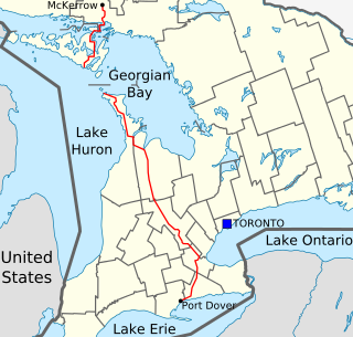
King's Highway 68, commonly referred to as Highway 68, was a provincially maintained highway on Manitoulin Island, linking the island to the mainland. It was connected to the rest of the network at McKerrow, where it met Highway 17. The road was built in the 1920s as a trunk road for the Department of Northern Development, but was assumed as a provincial highway in 1937, as the only King's Highway on the island. Highway 68 stretched from South Baymouth in the south, through the towns of Manitowaning and Little Current north to Espanola on the mainland.
Federal Highway 15 is Mexico 15 International Highway or Mexico-Nogales Highway, is a primary north-south highway, and is a free part of the federal highways corridors of Mexico. The highway begins in the north at the Mexico–United States border at the Nogales Port of Entry in Nogales, Sonora, and terminates to the south in Mexico City.
The Tres Marías island mouse or Tres Marías deer mouse is a species of rodent in the family Cricetidae. It is found only on the Islas Marías off the west coast of Mexico. When last assessed, it was common on María Cleofás Island, but rare or absent on the other, more disturbed, islands.
The Nayarit mouse or Sinaloan deer mouse is a species of cricetid rodent endemic to Mexico. It was considered a subspecies of brush mouse until 1977.
Federal Highway 68 (Fed. 68) is a free (libre) part of the federal highways corridors of Mexico. The highway connects Novillero, Nayarit in the west near the Pacific Ocean to Fed. 15.
Federal Highway 72 (Fed. 72) is a free (libre) part of the federal highways corridors of Mexico. The entire length of the highway is within Nayarit.
Federal Highway 76 (Fed. 76) is a free (libre) part of the federal highways corridors of Mexico. The entire length of the highway is within Nayarit.
Federal Highway 200, also known as Carretera Pacífico, is a Federal Highway of Mexico. The Carretera Pacífico is the main leg of the Pacific Coastal Highway within Mexico and travels along the Pacific Coast from Mexican Federal Highway 15 in Tepic, Nayarit in the north to the Guatemala-Mexico border at Talismán, Chiapas in the south. Upon entering Guatemala, the highway continues as Central American Highway 1.
Federal Highway 74 (Fed. 74) is a free (libre) part of the federal highways corridors of Mexico. The entire length of the highway is within Nayarit.

National Highway 68 is a National Highway in India connecting states of Rajasthan and Gujarat.
Federal Highway 70D is the designation for toll highways paralleling Mexican Federal Highway 70.
Federal Highway I-20D, known as the Libramiento de Irapuato, is a toll highway that serves as a bypass of the city of Irapuato, Guanajuato. The road is operated by HOATSA, which charges 68 pesos per vehicle to travel the full course of the highway. The road opened on March 15, 2011 at a construction cost of 900 million pesos.
Federal Highway 15D is the name for toll highways paralleling Federal Highway 15. The toll segments of Highway 15D include some of the most significant highways in the country along the Nogales-Mexico City corridor. The highway is the southern terminus of the CANAMEX Corridor, a trade corridor that stretches from Mexico north across the United States to the Canadian province of Alberta.
The Autopista Tepic–San Blas is a toll highway in the Mexican state of Nayarit. The 32.4-kilometre (20.1 mi) road was constructed and is operated by Red de Carreteras de Occidente, which charge cars 49 pesos or 69 pesos to travel the full length of the road.


