
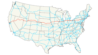
The Dwight D. Eisenhower National System of Interstate and Defense Highways, commonly known as the Interstate Highway System, is a network of controlled-access highways that forms part of the National Highway System in the United States. The system is named for President Dwight D. Eisenhower, who championed its formation. Construction was authorized by the Federal Aid Highway Act of 1956, and the original portion was completed 35 years later, although some urban routes were cancelled and never built. The network has since been extended. In 2016, it had a total length of 48,181 miles (77,540 km). As of 2016, about one-quarter of all vehicle miles driven in the country use the Interstate system. In 2006, the cost of construction was estimated at about $425 billion.
Interstate 80 (I-80) is an east–west transcontinental freeway in the United States that runs from downtown San Francisco, California, to Teaneck, New Jersey, in the New York City Metropolitan Area. The highway was designated in 1956 as one of the original routes of the Interstate Highway System. Its final segment was opened to traffic in 1986. It is the second-longest Interstate Highway in the United States, following I-90. The Interstate runs through many major cities including Oakland, Sacramento, Reno, Salt Lake City, Omaha, Des Moines, and Toledo, and passes within 10 miles (16 km) of Chicago, Cleveland, and New York City.
Interstate 180 (I-180) is a spur highway that connects Williamsport, Pennsylvania to Interstate 80 near Milton, Pennsylvania. The length of the highway is 28.85 miles (46.43 km). It was also the designation of present-day Interstate 176 between Morgantown, Pennsylvania and Reading, when the Pennsylvania Turnpike carried the "I-80S" designation in the 1960s. It is signed as an east–west route for its entire length, even though half of the route runs north–south.
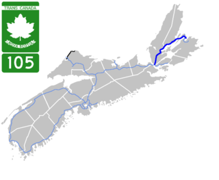
Highway 105 in Nova Scotia represents the Cape Breton Island leg of the Trans-Canada Highway. It runs from the Port Hastings Rotary just east of the Canso Causeway in Port Hastings to the Marine Atlantic ferry terminal in North Sydney, representing a distance of 142 kilometres (88 mi).

State Route 180 is a state highway in California, United States, which runs through the heart of the San Joaquin Valley from Mendota through Fresno to Kings Canyon National Park, with an unbuilt segment defined west to Paicines.
Highway 305 is a highway in the Canadian province of Saskatchewan. It runs from Highway 16 near Langham to Highway 11 near Warman. Highway 305 is about 30 km (19 mi) long.
Interstate 20 (I-20) is a part of the Interstate Highway System that spans 1,539.38 miles (2,477.39 km) from Reeves County, Texas to Florence, South Carolina. Within the state of Louisiana, the highway travels 189.84 miles (305.52 km) from the Texas state line west of Greenwood to the Mississippi River, which it crosses into Vicksburg, Mississippi.
Federal Highway 187 is a Federal Highway of Mexico. The highway travels from El Bellote, Centla Municipality, Tabasco in the north to Raudales Malpaso, Tecpatán Municipality, Chiapas in the south. Federal Highway 187 is one of two major north-south highway corridors in Tabasco. Federal Highway 187 route numbering continues as the Federal Highway 187D toll road from Raudales Malpaso south to Mexican Federal Highway 190 east of Ocozocoautla de Espinosa.
Federal Highway 172 is a Federal Highway of Mexico. The highway travels from Minatitlán, Veracruz in the west to Coatzacoalcos, Veracruz in the east. Federal Highway 172 serves as a bypass of Mexican Federal Highway 180 in Coatzacoalcos and is also the route leading from Minatitlán city proper to Minatitlán/Coatzacoalcos International Airport.
Federal Highway 305D is a toll highway in Quintana Roo. It serves as a spur of Federal Highway 180D (Mérida-Cancún) to Playa del Carmen, creating a direct connection between Yucatán and Playa del Carmen and avoiding detours through Cancún or Tulum.
Federal Highway 187D is a toll highway connecting Las Choapas, Veracruz to Ocozocuautla, Chiapas. The road is operated by Caminos y Puentes Federales, which charges 195 pesos
for the entire course of route.
Federal Highway 200D is the toll highways paralleling Fed. 200, and has two separate improved segments of designated roadway. Fed200D in Colima funnels traffic from Manzanillo toward Fed110 to Colima City; the segment in Guerrero serves as a bypass of Tecpan de Galeana.
Federal Highway 150D is a toll highway connecting Mexico City to Veracruz City via Puebla City and Córdoba. It serves as one of the backbones of Mexico's toll road system. The road is primarily operated by Caminos y Puentes Federales, which charges cars 520 pesos to travel Highway 150D, with one segment in the Puebla metropolitan area built and maintained by OHL and PINFRA.
Federal Highway 145D is a toll highway in the state of Veracruz. It connects southern Veracruz to Mexican Federal Highway 150D, continuing the other road's east-west trajectory. The road is operated by Caminos y Puentes Federales, who charges a toll of 183 pesos per car to travel Highway 145D.
Federal Highway 130D is a toll highway connecting Tuxpan, Veracruz to Gutiérrez Zamora, Veracruz. Its northern portion serves as the northern terminus of the México-Tuxpan highway corridor. The route is maintained and operated by Caminos y Puentes Federales.
Federal Highway 132D is the designation for toll highways paralleling Mexican Federal Highway 132. Highway 132D forms most of the Mexico City-Tuxpan highway corridor, with contiguous segments in the State of Mexico and from Tulancingo, Hidalgo to Tihuatlán, Veracruz.


