
San Luis Obispo County, officially the County of San Luis Obispo, is a county on the Central Coast of California. As of the 2020 census, the population was 282,424. The county seat is San Luis Obispo.
The Chumash are a Native American people of the central and southern coastal regions of California, in portions of what is now Kern, San Luis Obispo, Santa Barbara, Ventura and Los Angeles Counties, extending from Morro Bay in the north to Malibu in the south to Mt Pinos in the east. Their territory includes three of the Channel Islands: Santa Cruz, Santa Rosa, and San Miguel; the smaller island of Anacapa was likely inhabited seasonally due to the lack of a consistent water source.

Morro Bay is a seaside city in San Luis Obispo County, California, United States. Located on the Central Coast of California, the city population was 10,757 as of the 2020 census, up from 10,234 at the 2010 census. The town overlooks Morro Bay, a natural embayment with an all-weather small craft commercial and recreational harbor.
Morro Bay State Park is a state park on the Morro Bay lagoon, in western San Luis Obispo County, on the Central Coast of California. On the lagoon's northeastern and eastern edges in the park, there are saltwater and brackish marshes that support thriving bird populations.

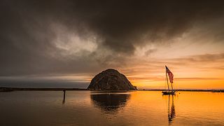
Morro Rock is a volcanic plug in Morro Bay, California, on the Pacific Coast at the entrance to Morro Bay harbor. A causeway connects it with the shore, making it a tied island. The rock is protected as the Morro Rock State Preserve.

Los Osos is an unincorporated town in San Luis Obispo County, California, United States. Located on the Central Coast of California, Los Osos had a reported population of 14,465 in 2020. For statistical purposes, the United States Census Bureau has defined Los Osos as a census-designated place (CDP).
The El Paso Mountains are located in the northern Mojave Desert, in central Southern California in the Western United States.

Cayucos State Beach is a protected beach in the state park system of California, United States. It is located in Cayucos, San Luis Obispo County. The sandy beach environment supports uses of swimming and surfing. Prehistorically this general area of the central coast was inhabited by the Chumash people, who settled the coastal San Luis Obispo area approximately 10,000 to 11,000 BCE, including a large village to the south of Cayucos at Morro Creek. The 16-acre (6.5 ha) park was established in 1940.
Tresus capax is a species of saltwater clam, marine bivalve mollusk, common name the fat gaper, in the family Mactridae. It also shares the common name horse clam with Tresus nuttallii a species which is similar in morphology and lifestyle. Both species are somewhat similar to the geoduck, though smaller, with shells up to eight inches long (20 cm), weight to 3–4 lb (1.4–1.8 kg).
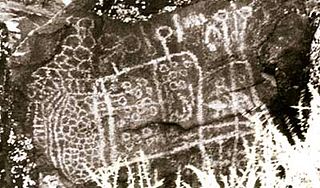
Big and Little Petroglyph Canyons are two principal landforms within which are found major accumulations of Paleo-Indian and/or Native American Petroglyphs, or rock art, by the Coso People located in the Coso Range Mountains of the northern Mojave Desert, and now within the Naval Air Weapons Station China Lake, near the towns of China Lake and Ridgecrest, California. Little Petroglyph Canyon contains 20,000 documented images, which surpasses in number for most other collections. Additionally, the archeological resources are remarkably undisturbed.

Hearst San Simeon State Park is a state park of California, United States, preserving rocky coast and rare habitats. It is located between Cambria and San Simeon. The 3,409-acre (1,380 ha) park was first established in 1932. The park includes the Santa Rosa Creek Natural Preserve, the San Simeon Natural Preserve and the Pa-nu Cultural Preserve, which were established in 1990.
Morro Creek is a coastal stream in San Luis Obispo County, in the central region of the U.S. state of California. The watercourse flows from the Santa Lucia Mountains to discharge into the Pacific Ocean, at its mouth on Estero Bay, near the city of Morro Bay.

Saxidomus nuttalli is a species of large edible saltwater clam, a marine bivalve mollusk in the family Veneridae, the venus clams. Common names include California butterclam and Washington clam.
Los Osos Back Bay is a prehistoric Chumash archaeological site in the Los Osos Valley, near the coast in San Luis Obispo County, California.

China Lake is an unincorporated community in Kern County, California. It is located 2.5 miles (4 km) north-northeast of Ridgecrest, at an elevation of 2,264 feet. The place is on China Lake, a dry lake near the Naval Air Weapons Station China Lake.

Casa Diablo Hot Springs is a hot springs and active geothermal location, near Mammoth Lakes and the Eastern Sierra Nevada, in Mono County, eastern California.

Tresus nuttallii, common name the Pacific gaper, is a species of saltwater clam, a marine bivalve mollusk in the family Mactridae. It also shares the common name horse clam with Tresus capax, a species which is similar in morphology and lifestyle. Both species are somewhat similar to the Geoduck, though smaller, with shells up to eight inches long (20 cm), weight to 3–4 lb (1.4–1.8 kg).
Jon M. Erlandson is an archaeologist, professor emeritus in the Department of Anthropology at the University of Oregon, and the former director of the University of Oregon Museum of Natural and Cultural History. Erlandson’s research interests include coastal adaptations, the peopling of North America, maritime archaeology and historical ecology and human impacts in coastal ecosystems.
St. Jones Neck is a geographic region of eastern central Kent County, Delaware, United States, with a rich prehistory and colonial history. Originally known just as Jones Neck, it is bounded on the west by the St. Jones River, on the north by Little Creek, and on the east by Delaware Bay. The area consists of low rolling hills that do not rise very much above sea level, interspersed with bodies of fresh and salt water. Streams are headed by marshes, and there are tidal marshlands along the bay. The neck has pockets of woodland which are concentrated near the freshwater marshes and tributaries. Land use in the neck is at present predominantly agricultural.
Humaliwo was a Chumash village located in present-day Malibu, California. “Humaliwo” meant "where the surf sounds loudly." The village occupied a hill across from the lagoon in Malibu Lagoon State Beach. The neighboring Tongva referred to the village as Ongobehangna. The Humaliwo village was recorded on the National Register of Historic Places (NRHP) in 1976. Cultural remains are present at this site, consisting of numerous human burials, artifacts and other cultural materials. Sections of the site can be dated to 7,000 years old.