Mont-Saint-Michel, Quebec

Last updated

Mont-Saint-Michel
Mont-St-Michel QC 1.JPG
Motto: 
Vaillants comme nos pionniers (Valiant like our pioneers)
Mont-Saint-Michel Quebec location diagram.png
Location within Antoine-Labelle RCM
Canada Central Quebec location map.png
Red pog.svg
Mont-Saint-Michel
Location in central Quebec
Coordinates: 46°47′N75°20′W / 46.783°N 75.333°W / 46.783; -75.333 [1]
CountryFlag of Canada (Pantone).svg  Canada
Province Flag of Quebec.svg  Quebec
Region Laurentides
RCM Antoine-Labelle
ConstitutedSeptember 11, 1928
Government
[2]
  MayorAndré-Marcel Evéquoz
   Federal riding Laurentides—Labelle
   Prov. riding Labelle
Area
  Total145.14 km2 (56.04 sq mi)
  Land138.16 km2 (53.34 sq mi)
Population
 (2021) [3]
  Total581
  Density4.2/km2 (11/sq mi)
  Pop, 2016-2021
Increase2.svg 0.9%
  Dwellings
382
Time zone UTC−5 (EST)
  Summer (DST) UTC−4 (EDT)
Postal code(s)
Area code 819
HighwaysQc309.svg R-309
Qc311.svg R-311
Website www.montsaintmichel.ca OOjs UI icon edit-ltr-progressive.svg

Mont-Saint-Michel is a municipality in the Laurentides region of Quebec, Canada, part of the Antoine-Labelle Regional County Municipality.

Contents

Geography

The main population centre of Mont-Saint-Michel is located 35 kilometres (22 mi) north of Mont-Laurier on the western banks of the Lièvre River. Its territory is characterized by a vast swamp and natural bog. Lake Gravel is one notable lake with vacation cottages surrounding it. [4]

History

The place was originally called Saint-Michel-des-Cèdres, but it was renamed to avoid confusion with the similarly named Saint-Michel-des-Saints. In 1912, its post office opened, and in 1915, a parish was set up as a mission under the name Saint-Michel-Archange. [1]

On September 11, 1928, the Municipality of Mont-Saint-Michel was created out of territory ceded from the United Township Municipality of Wurtele, Moreau et Gravel and Township of Décarie. [5]

Demographics

Canada census – Mont-Saint-Michel community profile
2021 2016
Population581 (+0.9% from 2016)576 (-9.0% from 2011)
Land area138.16 km2 (53.34 sq mi)139.02 km2 (53.68 sq mi)
Population density4.2/km2 (11/sq mi)4.1/km2 (11/sq mi)
Median age55.6 (M: 56.0, F: 55.2)53.4 (M: 54.8, F: 52.6)
Private dwellings382 (total)  280 (occupied)424 (total) 
Median household income$54,400$46,976
References: 2021 [6] 2016 [7] earlier [8] [9]
Historical census populations – Mont-Saint-Michel, Quebec
YearPop.±%
1976 672    
1981 705+4.9%
1986 680−3.5%
1991 647−4.9%
1996 616−4.8%
YearPop.±%
2001 619+0.5%
2006 625+1.0%
2011 633+1.3%
2016 576−9.0%
2021 581+0.9%
Source: Statistics Canada

Private dwellings occupied by usual residents (2021): 280 (total dwellings: 382) [3]

Mother tongue:

Local government

Mont-St-Michel municipal hall Mont-St-Michel QC 2.JPG
Mont-St-Michel municipal hall

List of former mayors:

See also

Related Research Articles

<span class="mw-page-title-main">Notre-Dame-du-Mont-Carmel, Quebec</span> Parish municipality in Quebec, Canada

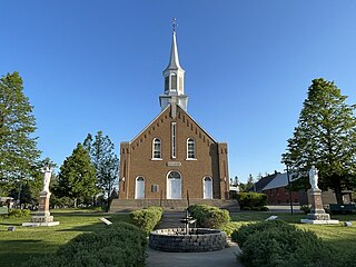
Notre-Dame-du-Mont-Carmel in the Mauricie region of the province of Quebec in Canada.

<span class="mw-page-title-main">Nominingue</span> Municipality in Quebec, Canada

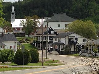
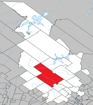
Nominingue is a small village and municipality located 200 kilometres (120 mi) north of Montreal, Quebec, Canada, in the Laurentian Mountains. It was formerly called Lac-Nominingue, but changed name on September 16, 2000.

<span class="mw-page-title-main">Saint-Alexis-des-Monts, Quebec</span> Parish municipality in Quebec, Canada

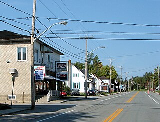
Saint-Alexis-des-Monts is a parish municipality in the Mauricie region of the province of Quebec in Canada.

<span class="mw-page-title-main">Lac-Supérieur, Quebec</span> Municipality in Quebec, Canada

Lac-Supérieur is a municipality in the Laurentides region of Quebec, Canada, part of the Les Laurentides Regional County Municipality. It is named after Lake Superior which is located in the Laurentian Mountains, due east of Mont Tremblant Resort. The community of Lac-Supérieur is just south of the lake, which itself is ringed with cottages. The entire northern portion of the municipality is mostly undeveloped and part of the Mont-Tremblant National Park.

<span class="mw-page-title-main">Fugèreville</span> Municipality in Quebec, Canada

Fugèreville is a municipality in northwestern Quebec, Canada in the Témiscamingue Regional County Municipality.

<span class="mw-page-title-main">Moffet, Quebec</span> Municipality in Quebec, Canada

Moffet is a municipality in northwestern Quebec, Canada, in the Témiscamingue Regional County Municipality. The municipality had a population of 206 as of the 2021 Canadian census.

<span class="mw-page-title-main">Saint-Édouard-de-Fabre</span> Parish municipality in Quebec, Canada

Saint-Édouard-de-Fabre is a parish municipality in western Quebec, Canada, in the Témiscamingue Regional County Municipality.

<span class="mw-page-title-main">Sainte-Anne-du-Lac</span> Municipality in Quebec, Canada

Sainte-Anne-du-Lac is a municipality and village in the Laurentides region of Quebec, Canada, part of the Antoine-Labelle Regional County Municipality.

<span class="mw-page-title-main">Mont-Blanc, Quebec</span> Municipality in Quebec, Canada

Mont-Blanc, is a municipality in the Laurentides region of Quebec, Canada, part of the Les Laurentides Regional County Municipality.

<span class="mw-page-title-main">Labelle, Quebec</span> Municipality in Quebec, Canada

Labelle is a village and municipality in the Laurentides region of Quebec, Canada, part of the Les Laurentides Regional County Municipality. Its large L-shaped territory surrounds Lake Labelle, and the village is located along the Rouge River and Route 117.

<span class="mw-page-title-main">Sainte-Lucie-des-Laurentides</span> Municipality in Quebec, Canada

Sainte-Lucie-des-Laurentides is a municipality in the Laurentides region of Quebec, Canada, part of the Les Laurentides Regional County Municipality.

<span class="mw-page-title-main">Saint-Aimé-du-Lac-des-Îles</span> Municipality in Quebec, Canada

Saint-Aimé-du-Lac-des-Îles is a municipality in the Laurentides region of Quebec, Canada, part of the Antoine-Labelle Regional County Municipality.

<span class="mw-page-title-main">Lac-Saguay</span> Village municipality in Quebec, Canada

Lac-Saguay is a village municipality in Antoine-Labelle Regional County Municipality in the Laurentides region of Quebec, Canada.

<span class="mw-page-title-main">Lac-Saint-Paul, Quebec</span> Municipality in Quebec, Canada

Lac-Saint-Paul is a municipality in the Laurentides region of Quebec, Canada, part of the Antoine-Labelle Regional County Municipality.

<span class="mw-page-title-main">Ferme-Neuve</span> Municipality in Quebec, Canada

Ferme-Neuve is a municipality part of the Antoine-Labelle Regional County Municipality, in the Laurentides region of Quebec, Canada. It is the largest incorporated municipality of the Laurentides region.

<span class="mw-page-title-main">L'Ascension, Quebec</span> Municipality in Quebec, Canada

L'Ascension is a municipality in the Laurentides region of Quebec, Canada, part of the Antoine-Labelle Regional County Municipality. The area is known as La Vallée de la Rouge.

<span class="mw-page-title-main">Mont-Saint-Pierre, Quebec</span> Village municipality in Quebec, Canada

Mont-Saint-Pierre is a village municipality in Quebec, Canada, located in the regional county municipality of La Haute-Gaspésie in the administrative region of Gaspésie–Îles-de-la-Madeleine.

<span class="mw-page-title-main">Saint-Joseph-de-Lepage</span> Parish municipality in Quebec, Canada

Saint-Joseph-de-Lepage is a parish municipality in La Mitis Regional County Municipality in the Bas-Saint-Laurent region of Quebec, Canada.

<span class="mw-page-title-main">Saint-Côme, Quebec</span> Municipality in Quebec, Canada

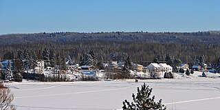
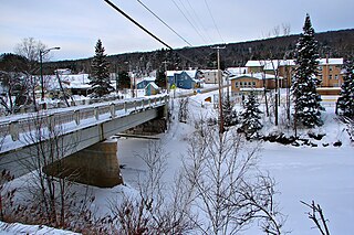
Saint-Côme is a municipality in the Lanaudière region of Quebec, Canada, part of the Matawinie Regional County Municipality.

<span class="mw-page-title-main">Saint-Guillaume-Nord, Quebec</span> Unorganized territory in Quebec, Canada

Saint-Guillaume-Nord is the southernmost unorganized territory in the Lanaudière region of Quebec, Canada, part of the Matawinie Regional County Municipality.

References

  1. 1 2 "Banque de noms de lieux du Québec: Reference number 42206". toponymie.gouv.qc.ca (in French). Commission de toponymie du Québec.
  2. 1 2 "Répertoire des municipalités: Geographic code 79110". www.mamh.gouv.qc.ca (in French). Ministère des Affaires municipales et de l'Habitation.
  3. 1 2 3 "Mont-Saint-Michel, Municipalité (MÉ) Census Profile, 2021 Census of Population". www12.statcan.gc.ca. Government of Canada - Statistics Canada. Retrieved 30 June 2022.
  4. "Histoire et patrimoine". www.montsaintmichel.ca (in French). Municipalité de Mont-Saint-Michel. Retrieved 30 June 2022.
  5. "Répertoire des entités géopolitiques: Mont-Saint-Michel (municipalité) 11.9.1928 - ..." www.mairesduquebec.com. Institut généalogique Drouin. Retrieved 30 June 2022.
  6. "2021 Community Profiles". 2021 Canadian Census . Statistics Canada. February 4, 2022. Retrieved 2023-10-19.
  7. "2016 Community Profiles". 2016 Canadian Census . Statistics Canada. August 12, 2021. Retrieved 2022-06-30.
  8. "2006 Community Profiles". 2006 Canadian Census . Statistics Canada. August 20, 2019.
  9. "2001 Community Profiles". 2001 Canadian Census . Statistics Canada. July 18, 2021.