Morton, Mississippi

Last updated

Morton, Mississippi
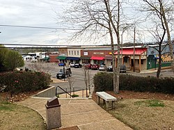
Downtown Morton MS.jpg
Downtown Morton, 2013
Flag of Morton, Mississippi.png
Scott County Mississippi Incorporated and Unincorporated areas Morton Highlighted.svg
Location of Morton, Mississippi
Usa edcp location map.svg
Red pog.svg
Morton, Mississippi
Location in the United States
Coordinates: 32°20′57″N89°39′16″W / 32.34917°N 89.65444°W / 32.34917; -89.65444
Country United States
State Mississippi
County Scott
Area
[1]
  Total8.92 sq mi (23.11 km2)
  Land8.89 sq mi (23.02 km2)
  Water0.04 sq mi (0.09 km2)
Elevation
472 ft (144 m)
Population
 (2020)
  Total3,711
  Density417.58/sq mi (161.22/km2)
Time zone UTC-6 (Central (CST))
  Summer (DST) UTC-5 (CDT)
ZIP code
39117
Area code 601
FIPS code 28-49080
GNIS feature ID0694044
Website City website

Morton is a city in Scott County, Mississippi, United States. The population was 3,462 at the 2010 census.

Contents

Geography

Morton is surrounded by the Bienville National Forest. Roosevelt State Park is southwest of the community.

According to the United States Census Bureau, the city has a total area of 6.8 square miles (18 km2), of which 6.7 square miles (17 km2) are land and 0.04-square-mile (0.10 km2) (0.59%) is water.

Demographics

Historical population
CensusPop.Note
1900 200
1910 37487.0%
1920 43716.8%
1930 955118.5%
1940 934−2.2%
1950 1,66478.2%
1960 2,26035.8%
1970 2,67218.2%
1980 3,30323.6%
1990 3,212−2.8%
2000 3,4828.4%
2010 3,462−0.6%
2020 3,7117.2%
U.S. Decennial Census [2]

2020 census

Morton Racial Composition [3]
RaceNum.Perc.
White 1,06328.64%
Black or African American 1,16731.45%
Native American 491.32%
Asian 40.11%
Other/Mixed 842.26%
Hispanic or Latino 1,34436.22%

As of the 2020 United States Census, there were 3,711 people, 1,006 households, and 893 families residing in the city.

2010 census

As of the 2010 census, there were 3,462 people, 1,133 households, and 797 families residing in the city. The population density was 517.9 inhabitants per square mile (200.0/km2). There were 1,289 housing units at an average density of 191.7 per square mile (74.0/km2). The racial makeup of the city was 44.5% White, 35.9% African American, 0.3% Native American, 0.1% Asian, 0.1% Pacific Islander, 16.8% from other races, and 2.2% from two or more races. Hispanic or Latino were 25.7% (16.1% Mexican, 3.3% Guatemalan, 1.4% Cuban, 1.0% Nicaraguan, 0.8% Argentinean). [4] [5]

There were 1,197 households, out of which 35.1% had children under the age of 18 living with them, 43.3% were married couples living together, 21.5% had a female householder with no husband present, and 28.8% were non-families. 24.5% of all households were made up of individuals, and 10.4% had someone living alone who was 65 years of age or older. The average household size was 2.78 and the average family size was 3.26.

In the city, the population was spread out, with 27.8% under the age of 18, 10.0% from 18 to 24, 26.5% from 25 to 44, 21.2% from 45 to 64, and 14.5% who were 65 years of age or older. The median age was 35 years. For every 100 females, there were 89.3 males. For every 100 females age 18 and over, there were 82.7 males.

The median income for a household in the city was $25,491, and the median income for a family was $31,161. Males had a median income of $26,649 versus $16,731 for females. The per capita income for the city was $12,556. About 18.9% of families and 24.6% of the population were below the poverty line, including 32.5% of those under age 18 and 22.4% of those age 65 or over.
Economy

The main employers are chicken processing plants. The largest poultry plant is owned by Koch Foods Inc. [6]

Education

The City of Morton is served by the Scott County School District. [7]

Notable people

Related Research Articles

<span class="mw-page-title-main">Hazleton, Iowa</span> City in Iowa, United States

Hazleton is a city in Buchanan County, Iowa, United States. The population was 713 at the time of the 2020 census.

<span class="mw-page-title-main">Stanley, Iowa</span> City in Iowa, United States

Stanley is a city in Buchanan and Fayette counties in the U.S. state of Iowa. The population was 81 at the time of the 2020 census.

<span class="mw-page-title-main">Long Grove, Iowa</span> City in Iowa, United States

Long Grove is a city in Scott County, Iowa, United States. The population was 838 at the time of the 2020 census.

<span class="mw-page-title-main">Maysville, Iowa</span> City in Iowa, United States

Maysville is a city in Scott County, Iowa, United States. The population was 156 at the time of the 2020 census.

<span class="mw-page-title-main">McCausland, Iowa</span> City in Iowa, United States

McCausland is a city in Butler Township, Scott County, Iowa, United States. The population was 313 at the time of the 2020 census.

<span class="mw-page-title-main">Princeton, Iowa</span> City in Iowa, United States

Princeton is a city in Scott County, Iowa, United States. The population was 923 at the time of the 2020 census.

<span class="mw-page-title-main">Palisade, Minnesota</span> City in Minnesota, United States

Palisade is a city in Aitkin County, Minnesota, United States. The population was 167 at the 2010 census.

<span class="mw-page-title-main">Fort Ripley, Minnesota</span> City in Minnesota, United States

Fort Ripley is a city in Crow Wing County, Minnesota, United States, near the confluence of the Mississippi and Nokasippi Rivers. The population was 69 at the 2010 census. It is part of the Brainerd Micropolitan Statistical Area.

<span class="mw-page-title-main">Coates, Minnesota</span> Town in Minnesota

Coates is a town in the U.S. state of Minnesota located west of the Upper Mississippi River on the exurban fringe in central Dakota County.

<span class="mw-page-title-main">Carlos, Minnesota</span> City in Minnesota, United States

Carlos is a city in Douglas County, Minnesota, United States. The population was 497 at the 2020 census.

<span class="mw-page-title-main">Evansville, Minnesota</span> City in Minnesota, United States

Evansville is a city in Douglas County, Minnesota, United States. The population was 603 at the 2020 census.

<span class="mw-page-title-main">Forada, Minnesota</span> City in Minnesota, United States

Forada is a city in Douglas County, Minnesota, United States. The population was 170 at the 2020 census.

<span class="mw-page-title-main">Wendell, Minnesota</span> City in Minnesota, United States

Wendell is a city in Grant County, Minnesota, United States. The population was 167 at the 2010 census.

<span class="mw-page-title-main">Isanti, Minnesota</span> City in the United States

Isanti is a city in Isanti County, Minnesota, United States. The population was 6,804 at the 2020 census. The name Isanti is composed of two Dakota words: isan ("knife") and ati ("camp"), and refers to the Santee Dakota people.

<span class="mw-page-title-main">Morton, Minnesota</span> City in Minnesota, United States

Morton is a city in Renville County, Minnesota, United States. This city is ninety-five miles southwest of Minneapolis. It is the administrative headquarters of the Lower Sioux Indian Reservation. The population was 411 at the 2010 census.

<span class="mw-page-title-main">Dellwood, Minnesota</span> City in Minnesota, United States

Dellwood is a city in Washington County, Minnesota, United States and a suburb of St. Paul. The population was 1,063 at the 2010 census.

<span class="mw-page-title-main">Forest, Mississippi</span> City in Mississippi, United States

Forest is a city and the county seat of Scott County, Mississippi, United States. The population was 5,684 at the 2010 census and the population is a minority-majority.

<span class="mw-page-title-main">Lake Morton-Berrydale, Washington</span> Census-designated place in Washington, United States

Lake Morton-Berrydale is a census-designated place (CDP) in King County, Washington, United States. The population was 10,474 at the 2020 census.

<span class="mw-page-title-main">Nettleton, Mississippi</span> Town in Mississippi, United States

Nettleton is a town in Lee and Monroe counties in Mississippi. The population was 1,935 at the 2020 census. Incorporated in 1888, the town was named after George Henry Nettleton, president of the Kansas City, Memphis and Birmingham Railroad (KCM&B).

<span class="mw-page-title-main">Scott City, Missouri</span> City in Missouri, United States

Scott City is a city in Cape Girardeau and Scott counties in the U.S. state of Missouri. The population was 4,346 at the 2020 census. The Scott County portion of Scott City is part of the Sikeston Micropolitan Statistical Area, while the Cape Girardeau County portion is part of the Cape Girardeau–Jackson, MO-IL Metropolitan Statistical Area.

References

  1. "2020 U.S. Gazetteer Files". United States Census Bureau. Retrieved July 24, 2022.
  2. "Census of Population and Housing". Census.gov. Retrieved June 4, 2015.
  3. "Explore Census Data". data.census.gov. Retrieved December 8, 2021.
  4. American FactFinder - Results
  5. American FactFinder - Results [ dead link ]
  6. SHAPIRO, ARI; CONTRERAS, GUS; BLANCHARD, DAVE (November 17, 2019). "Months After Massive ICE Raid, Residents Of A Mississippi Town Wait And Worry". NPR News. Retrieved November 18, 2019.
  7. "2020 CENSUS - SCHOOL DISTRICT REFERENCE MAP: Scott County, MS" (PDF). U.S. Census Bureau. Archived (PDF) from the original on August 7, 2022. Retrieved August 6, 2022. - Text list

Commons-logo.svg Media related to Morton, Mississippi at Wikimedia Commons