
Mount Timpanogos, often referred to as Timp, is the second-highest mountain in Utah's Wasatch Range. Timpanogos rises to an elevation of 11,752 ft (3,582 m) above sea level in the Uinta-Wasatch-Cache National Forest. With 5,270 ft (1,610 m) of topographic prominence, Timpanogos is the 47th-most prominent mountain in the contiguous United States.

Mount Charleston, including Charleston Peak at 11,916 feet (3,632 m), is the highest mountain in both the Spring Mountains and Clark County, in Nevada, United States. It is the eighth-highest mountain in the state. Well separated from higher peaks by large, low basins, Charleston Peak is the most topographically prominent peak in Nevada, and the eighth-most-prominent peak in the contiguous United States. It is one of eight ultra-prominent peaks in Nevada. It is located about 35 miles (56 km) northwest of Las Vegas within the Mount Charleston Wilderness, which is within the Spring Mountains National Recreation Area of the Humboldt–Toiyabe National Forest.

Wheeler Peak is the tallest mountain in the Snake Range and in White Pine County, in Nevada, United States. The summit elevation of 13,065 feet (3,982 m) makes it the second-highest peak in Nevada, just behind Boundary Peak. With a topographic prominence of 7,563 feet (2,305 m), Wheeler Peak is the most topographically prominent peak in White Pine County and the second-most prominent peak in Nevada, just behind Mount Charleston. The mountain is located in Great Basin National Park and was named for George Wheeler, leader of the Wheeler Survey of the late 19th century.

Kings Peak is the highest peak in the U.S. state of Utah, with an elevation of 13,528 feet (4,123 m) NAVD 88.

Cloud Peak is the highest peak within the Bighorn Mountains in the U.S. state of Wyoming.

Mount Jefferson is the highest mountain in both the Toquima Range and Nye County in Nevada, United States. It is the sixth highest mountain in the state. As the high point of a range which is well separated from other ranges by low basins, Mount Jefferson has a high topographic prominence of 5,861 feet (1,786 m). This makes it the most prominent peak in Nye County and the third most prominent peak in Nevada. For similar reasons, it is also the highest mountain for over 90 miles in all directions. It is located about 50 miles (80 km) northeast of the county seat of Tonopah within the Alta Toquima Wilderness of the Humboldt-Toiyabe National Forest, near the smaller towns of Carvers and Round Mountain. Three distinct summits are located on a broad area of subalpine tundra: North Summit rises to 11,820 feet (3,603 m), Middle Summit to 11,692 feet (3,564 m), and South Summit to 11,949 feet (3,642 m). During the Pleistocene, alpine glaciers eroded several cirques east of the summit plateau.

The Pfeifferhorn is the 11,331 feet (3,454 m) triangularly-shaped peak located in the most isolated part of the Lone Peak Wilderness Area of the Wasatch Mountains in northern Utah, United States. This rugged Utah mountain, commonly referred to as the Little Matterhorn, is the fifth-highest peak in the Wasatch Range. The summit can be reached by hiking, though some scrambling is required. There are several technical rock climbing routes with the north ridge being the most popular. This summit also makes an excellent winter mountaineering adventure.

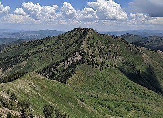
Deseret Peak is the highest peak in the Stansbury Mountains with an elevation of 11,035 ft. It is located in the Deseret Peak Wilderness area west of Grantsville, Utah and east of Skull Valley Indian Reservation. It is the fourth most topographically prominent peak in the state of Utah. The site is a popular destination for hikers and backcountry skiers as the area is a contrast of the alpine wilderness with the surrounding desert basin. The trail that leads to the peak is easily accessible from Salt Lake City. The mountain offers views of the Bonneville Salt Flats, the Great Salt Lake, and the surrounding towns and mountain ranges. On a clear day, it is possible to see Mount Nebo, the highest peak in the adjacent Wasatch Mountains.

Mount Peale is the highest point in the La Sal Mountains of San Juan County, in the southeastern part of Utah, United States. It is also the highest point in Utah outside the Uinta Mountains. It is located about 20 mi (32 km) southeast of Moab. The summit is the highest point in the Manti-La Sal National Forest and the Mount Peale Research Natural Area. Mount Peale was named for Albert Peale, a mineralogist on the Hayden Survey of 1875.

Bald Mountain is a 11,949-foot (3,642 m) peak in the western Uinta Mountain Range in the Uinta-Wasatch-Cache National Forest on the border between Summit and Wasatch counties in northeastern Utah, United States.

Mount Agassiz is a peak in the Uinta Mountains of northeastern Utah with an elevation of 12,433 feet (3,790 m). It is located in the High Uintas Wilderness and the Uinta-Wasatch-Cache National Forest. The summit is named in honor of Louis Agassiz, a well-known paleontologist, glaciologist and geologist.

Mount Baldy is an extinct stratovolcano in eastern Arizona in the United States. With a summit elevation of 11,409 feet (3,477 m), the peak of Mount Baldy rises above the tree line and is left largely bare of vegetation, lending the mountain its current name. The Mount Baldy Wilderness occupies the eastern slope of the mountain and is managed by the Apache-Sitgreaves National Forest.
Logan Peak, commonly referred to as Mount Logan, is a peak in the Bear River Mountains, a branch of the Wasatch Range. Located six miles east-southeast of Logan, Utah in the Uinta-Wasatch-Cache National Forest, it is the second highest peak overlooking Cache Valley after Mt. Naomi. Logan Peak rises to an elevation of 9,714 feet (2,961 m) NAVD88. It is served by hiking trails and a narrow, unpaved access road suitable only for offroad vehicles. It is the only mountain in the Bear River Range with a road to the summit. The peak houses a weather station and a telecommunications tower. Logan Peak is a popular destination for hikers and mountain bikers during the warmer months and advanced cross-country skiers in winter. During the winter, a circular hollow on the east side of the peak, known locally as Crystal Valley, is popular with snowmobilers.

Naomi Peak, or Mount Naomi, is the highest peak in the Bear River Range in northern Utah and southern Idaho, United States.

Sacajawea Peak is a peak in the Wallowa Mountains, in the U.S. state of Oregon. It is in the Eagle Cap Wilderness and the Wallowa–Whitman National Forest.

Bull Mountain, an officially unnamed summit in northern Utah, United States, has an elevation of 9,938 feet (3,029 m). It is the highest point in the Raft River Mountains and Box Elder County.

Ostler Peak is a 12,718-foot elevation (3,876 m) mountain summit located in Summit County, Utah, United States.

Mount Lovenia is a 13,219-foot elevation (4,029 m) mountain summit located on the common border that Duchesne County shares with Summit County in the U.S. state of Utah.

Mount Beulah is a 12,557-foot elevation (3,827 m) mountain summit located in Summit County, Utah, United States.
Gobblers Knob is a 10,246-foot elevation (3,123 m) mountain summit located in Salt Lake County, Utah, United States.
 Mount Nebo (left of center) aerial view from the south, with Utah Lake and the rest of the Wasatch Range in the background and the Great Salt Lake on the far left horizon
 Mount Nebo eastern side during winter
 Panorama of Mount Nebo, 2007


