Mount Pershing

Last updated
Mount Pershing
Mount Pershing.jpg
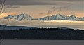
Mount Pershing (left) seen from West Seattle
(Jefferson Peak to the right)
Highest point
Elevation 6,154 ft (1,876 m) [1]
Prominence 1,114 ft (340 m) [1]
Parent peak Mount Washington (6,260 ft) [2]
Isolation 1.53 mi (2.46 km) [2]
Coordinates 47°33′08″N123°15′22″W / 47.552125°N 123.255973°W / 47.552125; -123.255973 [1]
Naming
Etymology John J. Pershing
Geography
USA Washington relief location map.jpg
Red triangle with thick white border.svg
Mount Pershing
Location of Mount Pershing in Washington
Usa edcp relief location map.png
Red triangle with thick white border.svg
Mount Pershing
Mount Pershing (the United States)
CountryUnited States
State Washington
County Mason
Protected area Mount Skokomish Wilderness
Parent range Olympic Mountains
Topo map USGS Mount Skokomish
Geology
Rock age Eocene
Rock type pillow basalt
Climbing
First ascent 1939 by Don Dooley, Robert Henderson, Walt Ingalls, and Bob Mandelhorn [3]
Easiest route class 3 scrambling via South Ridge [3]

Mount Pershing is a 6,154-foot-elevation (1,876-meter) massif in Mason County of Washington state, United States. [4] Part of the Olympic Mountains, it is situated in the Mount Skokomish Wilderness on land managed by Olympic National Forest. The mountain's toponym honors General of the Armies John J. Pershing (1860–1948). [5] The nearest higher neighbor is Mount Washington, 1.45 mi (2.33 km) to the south-southeast. [1] Precipitation runoff from its slopes drains into the Hamma Hamma River.

Contents

Climate

Mount Pershing is located in the marine west coast climate zone of western North America. [6] Weather fronts originating in the Pacific Ocean travel northeast toward the Olympic Mountains. As fronts approach, they are forced upward by the peaks (orographic lift), causing them to drop their moisture in the form of rain or snow. As a result, the Olympics experience high precipitation, especially during the winter months in the form of snowfall. [7] Because of maritime influence, snow tends to be wet and heavy, resulting in avalanche danger. During winter months weather is usually cloudy, but due to high pressure systems over the Pacific Ocean that intensify during summer months, there is often little or no cloud cover during the summer. [7] The months May through August offer the most favorable weather for viewing or climbing this mountain. [3]

Geology

The Olympic Mountains are composed of obducted clastic wedge material and oceanic crust, primarily Eocene sandstone, turbidite, and basaltic oceanic crust. [8] The mountains were sculpted during the Pleistocene era by erosion and glaciers advancing and retreating multiple times.

See also

Related Research Articles

<span class="mw-page-title-main">Mount Washington (Olympics)</span> Mountain in Washington, United States

Mount Washington is a 6,260-foot-tall (1,910 m) peak in the Olympic Mountains of Washington state. The mountain is located in the Mount Skokomish Wilderness.

<span class="mw-page-title-main">Mount Constance</span> Mountain in Washington (state), United States

Mount Constance is a peak in the Olympic Mountains of Washington and the third highest in the range. It is the most visually prominent peak on Seattle's western skyline. Despite being almost as tall as the ice-clad Mount Olympus to the west, Mount Constance has little in the way of glaciers and permanent snow because the eastern, and particularly this northeastern, portion of the Olympics receives far less precipitation. However the narrow and steep Crystal Glacier still exists on the mountain's north face, shaded by the bulk of the main peak and with a small lake at its terminus. In addition, the treeline is higher here than mountains to the west, also hinting at the drier alpine conditions.

<span class="mw-page-title-main">Mount Skokomish Wilderness</span> Wilderness area in Washington, United States

Mount Skokomish Wilderness is a designated wilderness area in the southeast portion of Olympic National Forest on the Olympic Peninsula of Washington in the United States. The wilderness area comprises 13,291 acres (5,379 ha) administered by the U.S. Forest Service.

<span class="mw-page-title-main">Mount Stone</span> Mountain in Washington (state), United States

Mount Stone is a 6,612-foot (2,015 m) peak in the Olympic Mountains. It is the highest point in Mason County, Washington and exceeds 2,000 feet (610 m) in prominence.

<span class="mw-page-title-main">Mount Skokomish</span> Mountain in Washington (state), United States

Mount Skokomish is a 6,434-foot (1,961 meter) mountain summit located in the Olympic Mountains, in Mason County of Washington state, United States. It is situated on the shared boundary of Olympic National Park with Mount Skokomish Wilderness, and it is the highest point of the wilderness. The nearest higher peak is Mount Stone, 1.66 mi (2.67 km) to the northeast. It is visible on the Olympic skyline from as far away as Seattle. Mt. Skokomish has three summits, the south peak being the highest. Precipitation runoff drains into the Hamma Hamma River and Skokomish River. Like the river, the mountain's toponym honors the Skokomish people.

<span class="mw-page-title-main">Mount Fricaba</span> Mountain in Washington (state), United States

Mount Fricaba is a 7,139-foot-elevation (2,176 m) double summit mountain located in the Olympic Mountains, in Jefferson County of Washington state. It is situated on the shared border of Olympic National Park with Buckhorn Wilderness, and is the highest point in that wilderness, as well as the Olympic National Forest. Its nearest higher peak is Hal Foss Peak, 0.74 miles (1.19 km) to the southwest. Precipitation runoff from the peak drains east into headwaters of the Dungeness River, or west into Deception Creek which is a tributary of the Dosewallips River. The mountain's name was officially adopted in 1961 by the United States Board on Geographic Names based on usage by The Mountaineers since 1907, and inclusion in Fred Beckey's "Climber's Guide to the Cascade and Olympic Mountains of Washington" published in 1949. The first ascent of the mountain was made in 1957 by Don Bechlem and Jack Newman.

<span class="mw-page-title-main">Mount Henderson (Washington)</span> Mountain in Mason County, Washington, United States

Mount Henderson is a 6,003-foot-elevation (1,830-meter) mountain summit located in the Olympic Mountains, in Mason County of Washington state, United States. It is situated on the shared boundary of Olympic National Park with Mount Skokomish Wilderness. Its nearest higher neighbor is Mount Skokomish, 0.91 mi (1.46 km) to the east-northeast. Precipitation runoff from the mountain drains into the Hamma Hamma River and Skokomish River. The mountain's toponym honors Louis Forniquet Henderson (1853-1942), a pioneering botanist and mountaineer who accompanied Lieutenant O'Neil on his 1890 expedition into the Olympic Mountains.

<span class="mw-page-title-main">Mount Cruiser</span> Mountain in Washington (state), United States

Mount Cruiser is a 6,104-foot-elevation (1,860-meter) mountain summit located in the Olympic Mountains, in Mason County of Washington state, United States. It is situated in Mount Skokomish Wilderness on land managed by Olympic National Forest. Cruiser is the highest point on Sawtooth Ridge, and its nearest higher peak is Mount Skokomish, 2.1 mi (3.4 km) to the north-northeast. Cruiser has two sub-peaks, Alpha, and Beta, the latter of which lies on the Olympic National Park boundary. The first ascent of the peak was made in 1937 by Paul Crews and Ray Layton. The mountain was named by the first ascent party to recognize their club, the Bremerton Ski Cruisers. The mountain's toponym was officially adopted in 1961 by the United States Board on Geographic Names. Precipitation runoff from the mountain drains into the Hamma Hamma River.

<span class="mw-page-title-main">Mount Pulitzer (Washington)</span> Mountain in Washington (state), United States

Mount Pulitzer, also known as Snagtooth, is a 6,283-foot (1,915-metre) mountain summit located within Olympic National Park in Jefferson County of Washington state. Mount Pulitzer is the sixth-highest peak in the Bailey Range, which is a subrange of the Olympic Mountains. Its nearest neighbor is Mount Ferry, 0.58 mi (0.93 km) to the northeast, and its nearest higher neighbor is Stephen Peak, 2.58 mi (4.15 km) to the north. Mount Olympus is set 6.8 mi (10.9 km) to the southwest. In clear weather, the mountain can be seen from the visitor center at Hurricane Ridge. Precipitation runoff from the mountain drains into tributaries of the Elwha and Hoh Rivers. The first ascent of the summit was made in 1961 by Doug Waali, Bob Wood, and Kent Heathershaw via the east ridge.

<span class="mw-page-title-main">Mount Claywood</span> Mountain in Washington (state), United States

Mount Claywood is a 6,836-foot (2,084-metre) mountain summit located within Olympic National Park in Jefferson County of Washington state. It is situated at the head of Lost River, and 15 mi (24 km) east of Mount Olympus. Its nearest higher neighbor is Mount Cameron, 2.4 mi (3.9 km) to the northeast. Other nearby peaks include Mt. Fromme, 0.58 mi (0.93 km) to the southeast, and Sentinel Peak, 2 mi (3.2 km) also to the southeast. Precipitation runoff from the mountain drains north and west into tributaries of the Elwha River, and east into Claywood Lake, thence Dosewallips River.

<span class="mw-page-title-main">Mount Lena (Washington)</span> Mountain in Washington (state), United States

Mount Lena is a 5,995-foot-elevation mountain summit located in the Olympic Mountains, in Jefferson County of Washington state. It is situated within Olympic National Park, immediately north and 1,500 feet above the shore of Upper Lena Lake. Mt. Lena has a subsidiary peak, East Peak (5800+ ft/1768+ m), which lies northeast of the lake. Mount Bretherton lies across the lake to the south, Mount Stone is three miles to the southwest, and The Brothers approximately 3.5 miles to the northeast. Precipitation runoff from the mountain drains north to the Duckabush River, and south into the Hamma Hamma River via Lena Creek. The non-technical ascent of Mount Lena involves hiking eight miles (one-way) and 5,300 feet elevation gain via the Upper Lena Lake Trail and cross-country above the lake, with most favorable conditions from July through September. There are pleasant campsites at the lake, and the ascent to the summit takes 1.5 hour from the lake. This mountain's toponym has been officially adopted by the United States Board on Geographic Names.

<span class="mw-page-title-main">Mount Seattle (Washington)</span> Mountain in Washington (state), United States

Mount Seattle is a 6,246-foot (1,904-metre) mountain summit deep within Olympic National Park in Jefferson County of Washington state. Part of the Olympic Mountains, Mount Seattle is situated 7.5 miles southeast of Mount Olympus, and set within the Quinault Rainforest and Daniel J. Evans Wilderness. The nearest higher neighbor is Mount Meany, 1.65 miles (2.66 km) to the north-northwest, and Mount Noyes rises one mile to the northwest. Precipitation runoff from the mountain drains north into headwaters of the Elwha River, and south into tributaries of the Quinault River. Topographic relief is significant as the northeast aspect of the peak rises over 3,800 feet (1,200 m) above the Elwha valley in approximately 1.5-mile. Low Divide forms the saddle between Mt. Seattle and Mount Christie.

<span class="mw-page-title-main">Mount Lincoln (Washington)</span> Mountain in Washington (state), United States

Mount Lincoln is a 5,868-foot (1,789-meter) mountain summit located in the Olympic Mountains, in Mason County of Washington state, United States. It is situated on the boundary shared by Daniel J. Evans Wilderness and Mount Skokomish Wilderness, as well as the shared common border of Olympic National Park with Olympic National Forest. Lincoln is the second-highest point on Sawtooth Ridge, and the nearest higher neighbor is Mount Cruiser, 1.1 mi (1.8 km) to the northeast. Lincoln has two sub-peaks: a North Peak, and a Southwest Peak. Flapjack Lakes lie immediately west below the north sub-peak. Topographic relief is significant as the summit rises over 5,100 feet (1,600 m) above the Staircase Ranger Station at Lake Cushman in approximately two miles. Precipitation runoff from the mountain drains into tributaries of the North Fork Skokomish River, and partly into Mildred Lakes, thence Hamma Hamma River.

<span class="mw-page-title-main">Mount Wilder</span> Mountain in Washington (state), United States

Mount Wilder is a 5,939-foot (1,810-metre) mountain summit located near the head of the Elwha Valley, deep within Olympic National Park in Jefferson County of Washington state. Part of the Olympic Mountains, Wilder represents the southernmost peak of the Bailey Range. It is situated 8.7 miles east-southeast of Mount Olympus, and is set within the Daniel J. Evans Wilderness. Neighbors include line parent Mount Dana, 2.3 miles (3.7 km) to the northeast, and Mount Seattle rises 3.7 miles to the southwest. The headwaters of the Goldie River form on the south slope of the mountain, and precipitation runoff from the mountain drains into Goldie River and other tributaries of the Elwha River. Topographic relief is significant as the south aspect of the peak rises nearly 3,800 feet (1,160 m) in less than two miles.

<span class="mw-page-title-main">Mount Delabarre</span> Mountain summit in Washington state

Mount Delabarre is a remote 6,024-foot (1,836-metre) mountain summit deep within Olympic National Park in Jefferson County of Washington state. Part of the Olympic Mountains, Mount Delabarre is 12.4 miles southeast of Mount Olympus, set within the Daniel J. Evans Wilderness. The nearest higher neighbor is line parent Mount Christie, 2.5 miles to the west-northwest. Precipitation runoff from the mountain drains north into headwaters of Delabarre Creek, which is a tributary of the Elwha River, and south into Rustler Creek, which is a tributary of the North Fork Quinault River. Topographic relief is significant as the southwest aspect of the peak rises 3,400 feet (1,036 m) above Rustler Creek in approximately one mile.

<span class="mw-page-title-main">Mount Steel</span> Mountain in Washington, USA

Mount Steel is a 6,225-foot-elevation (1,897-meter) mountain summit located in the Olympic Mountains, in Jefferson County of Washington state. It is situated in Olympic National Park and the Daniel J. Evans Wilderness. The nearest higher neighbor is Mount Duckabush, 1.36 mi (2.19 km) to the southwest. Precipitation runoff from the mountain drains south into tributaries of the North Fork Skokomish River, and north into headwaters of the Duckabush River. Topographic relief is significant as the summit rises over 3,400 feet (1,036 m) above the Duckabush River in approximately one mile.

<span class="mw-page-title-main">Cat Peak</span> Mountain in Washington (state), United States

Cat Peak is a 5,940-foot (1,811-metre) mountain summit within Olympic National Park in Clallam County of Washington state.

<span class="mw-page-title-main">Mount Rose (Washington)</span> Mountain in Washington (state), United States

Mount Rose is a 4,301-foot-elevation (1,311 meter) mountain summit located in the southeast portion of the Olympic Mountains, in Mason County of Washington state. It is situated in the Mount Skokomish Wilderness, on land managed by Olympic National Forest. The nearest higher neighbor is line parent Copper Mountain, 1.2 mi (1.9 km) to the north, and Mount Ellinor is 1.7 mi (2.7 km) to the northeast. Precipitation runoff from the mountain drains into Lake Cushman, and topographic relief is significant as the summit rises approximately 3,600 feet (1,100 m) above the lake in less than one mile. Old-growth forests of Douglas fir, western hemlock, and western redcedar grow on the slopes surrounding the peak. In 2006, the Bear Gulch Fire scorched 750 acres of forest on the slopes of Mount Rose from lake level to the summit. Access to the summit is via the 3.2-mile-long Mt. Rose Trail which gains 3,500 feet of elevation.

<span class="mw-page-title-main">Copper Mountain (Mason County, Washington)</span> Mountain in Washington (state), United States

Copper Mountain is a 5,425-foot (1,654 m) mountain summit located in the southeast portion of the Olympic Mountains, in Mason County of Washington state. It is situated on the boundary shared by Daniel J. Evans Wilderness and Mount Skokomish Wilderness, as well as the shared common border of Olympic National Park with Olympic National Forest. The nearest higher neighbor is Mount Ellinor, 1.67 miles (2.69 km) to the east. Wagonwheel Lake lies immediately north of the peak. Topographic relief is significant as the summit rises nearly 4,700 feet (1,433 m) above the Staircase Ranger Station at Lake Cushman in approximately 1.5 miles (2.4 km). Precipitation runoff from the mountain drains north into the Hamma Hamma River, and south into the North Fork Skokomish River, thence Lake Cushman.

<span class="mw-page-title-main">Jefferson Peak</span> Mountain in Washington (state), United States

Jefferson Peak is a 5,720-foot (1,743 m) mountain summit located in the Olympic Mountains in Mason County of Washington state. It is situated in the Mount Skokomish Wilderness, on land managed by Olympic National Forest. The mountain's toponym honors Thomas Jefferson (1743–1826), the third president of the United States. The nearest higher neighbor is line parent Mount Pershing, 1.3 mi (2.1 km) to the southwest. Precipitation runoff drains into Jefferson Creek and the Hamma Hamma River. Topographic relief is significant as the north aspect rises over 4,100 feet (1,200 m) above the Hamma Hamma valley in approximately one mile.

References

  1. 1 2 3 4 "Mount Pershing". Peakbagger.com.
  2. 1 2 "Pershing, Mount - 6,154' WA". listsofjohn.com. Retrieved 2022-01-08.
  3. 1 2 3 Mount Pershing, climbersguideolympics.com
  4. "Mount Pershing". Geographic Names Information System . United States Geological Survey, United States Department of the Interior . Retrieved 2018-08-03.
  5. Olympic Mountain Rescue, Olympic Mountains: A Climbing Guide, 4th Edition, 2006, Mountaineers Books, ISBN   9780898862065, page 60.
  6. Peel, M. C.; Finlayson, B. L.; McMahon, T. A. (2007). "Updated world map of the Köppen−Geiger climate classification". Hydrol. Earth Syst. Sci. 11: 1633–1644. ISSN   1027-5606.
  7. 1 2 McNulty, Tim (2009). Olympic National Park: A Natural History. Seattle, Washington: University of Washington Press.
  8. Alt, D.D.; Hyndman, D.W. (1984). Roadside Geology of Washington. pp. 249–259. ISBN   0-87842-160-2.