Saint Ann is the largest parish in Jamaica. It is situated on the north coast of the island, in the county of Middlesex, roughly halfway between the eastern and western ends of the island. It is often called "the Garden Parish of Jamaica" on account of its natural floral beauty. Its capital is Saint Ann's Bay. Saint Ann comprises New Seville, the first Spanish Settlement in Jamaica.
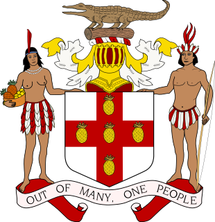
The parishes of Jamaica are the main units of local government in Jamaica. They were created following the English Invasion of Jamaica in 1655. This administrative structure for the Colony of Jamaica developed slowly. However, since 1 May 1867 Jamaica has been divided into the current fourteen parishes. These were retained after independence in 1962. They are grouped into three historic counties, which no longer have any administrative relevance. Every parish has a coast; none are landlocked.

Tattershall is a village and civil parish in the East Lindsey district of Lincolnshire, England. It is situated on the A153 Horncastle to Sleaford road, 1 mile (1.6 km) east from the point where that road crosses the River Witham. At its eastern end, Tattershall adjoins the village of Coningsby, with the two being separated by the River Bain.

Old Nanny Town was a village in the Blue Mountains of Portland Parish, north-eastern Jamaica, used as a stronghold of Jamaican Maroons. They were led in the early 18th century by an Ashanti escaped slave known as Granny Nanny, or Queen Nanny. The town held out against repeated British colonial attacks before being destroyed in 1734.

Saint Thomas, once known as Saint Thomas in the East, is a suburban parish situated at the south eastern end of Jamaica, within the county of Surrey. It is the birthplace of the Right Honourable Paul Bogle, designated in 1969 as one of Jamaica's seven National Heroes. Morant Bay, its chief town and capital, is the site of the Morant Bay Rebellion in 1865, of which Bogle was a leader.

Westmoreland is the westernmost parish in Jamaica, located on the south side of the island. It is situated south of Hanover, southwest of Saint James, and northwest of Saint Elizabeth, in the county of Cornwall. The chief town and capital is Savanna-la-Mar. Negril, a famous tourist destination, is also situated in the parish.

The Parish of Manchester is an administrative civil parish located in west-central Jamaica, in the county of Middlesex. Its capital, Mandeville, is a major business centre, and the only parish capital not located on the coast or on a major river. Its St. Paul of the Cross Pro-Cathedral is the episcopal see of the Latin Catholic Diocese of Mandeville.

May Pen is the capital and largest town in the parish of Clarendon in Middlesex County, Jamaica. It is located on the Rio Minho river, and is a major market centre for the Parish. The population was 61,548 at the 2011 census increasing from 59,550 in 2001, including the surrounding suburbs of Sandy Bay, Mineral Heights, Hazard, Palmers Cross, Denbigh, Race Track, and Four Paths among others. The town has a mayor.

The Blue Mountains are the longest mountain range in Jamaica. They include the island's highest point, Blue Mountain Peak, at 2256 m (7402 ft). From the summit, accessible via a walking track, both the north and south coasts of the island can be seen. On a clear day, the outline of the island of Cuba, 210 km (130 mi) away, can also be seen. The mountain range spans four parishes: Portland, St. Thomas, St. Mary and St. Andrew.
Colonel Sir Thomas Modyford, 1st Baronet was a planter of Barbados and Governor of Jamaica from 1664 to 1670.
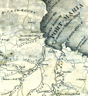
The Otram River, formerly the Port Maria River or the Port Maria Western River, is a river in Saint Mary Parish, Jamaica. It reaches the sea in the parish capital of Port Maria and contributes to flooding in that town.
Constant Spring is a residential neighbourhood in the north of Kingston, Jamaica.

Kells, a parish, in the Stewartry of Kirkcudbright, 14 miles from Castle-Douglas, and 19 from Kirkcudbright; containing, with the burgh of New Galloway, 1121 inhabitants.
Nathaniel Bayly (c.1726–1798) was a West Indies plantation owner and politician who sat in the House of Commons from 1770 to 1779.
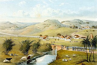
Trinity was a plantation in colonial Jamaica, located south of Port Maria, in Saint Mary Parish, one of several plantations owned by Zachary Bayly that formed part of the area known as Bayly's Vale. By the early nineteenth century, over 1,000 people were enslaved there producing mainly sugar and rum for which a mile-long aqueduct was built by Nathaniel Bayly to supply water for the refining process.

The West Indian Incumbered Estates Acts were Acts of the Parliament of the United Kingdom of 1854, 1858, 1862, 1864, 1872, and 1886 that allowed creditors and other interested parties to apply for the sale of estates (plantations) in the British colonies in the West Indies despite legal encumbrances that would normally prevent such a sale. The legislation was modelled on the acts that created the Irish Encumbered Estates' Court after the Great Famine of the 1840s that allowed indebted and moribund estates to be sold.

Brimmer Hall is a Jamaican Great House and 642 acre plantation located near Port Maria, in Saint Mary Parish, Jamaica. In the eighteenth century Brimmer Hall was owned by Zachary Bayly as part of a series of contiguous sugar plantations. These consisted of Trinity, Tryall, and Roslyn Pen as well as Brimmer Hall. Together they were known as Bayly's Vale. The land was worked by about 1,100 enslaved Africans in this period.