
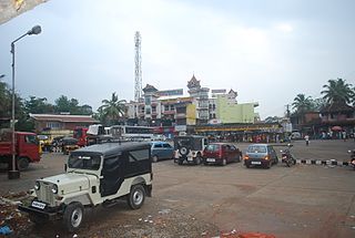
Palakkad is one of the 14 districts in the Indian state of Kerala. It was carved out of the southeastern region of the former Malabar District on 1 January 1957. It is located at the central region of Kerala and is the second largest district in the state after Idukki. The city of Palakkad is the district headquarters. Palakkad is bordered on the northwest by the Malappuram district, on the southwest by the Thrissur district, on the northeast by Nilgiris district, and on the east by Coimbatore district of Tamil Nadu. The district is nicknamed "The granary of Kerala". Palakkad is the gateway to Kerala due to the presence of the Palakkad Gap, in the Western Ghats. The 2,383 m high Anginda peak, which is situated in the border of Palakkad district, Nilgiris district, and Malappuram district, in Silent Valley National Park, is the highest point of elevation in Palakkad district. Palakkad city is about 347 kilometres (216 mi) northeast of the state capital, Thiruvananthapuram.

Nelliyampathy is a hill station, located 60 kilometres (37 mi) from Palakkad, state of Kerala, India.
Anchal is an urban town located in the centre of Kollam district in Kerala, India.
Thamarakulam is a village in Alappuzha district in the Indian state of Kerala. Located in Alappuzha District of Kerala, Thamarakulam is around 16 km south-east of Kayamkulam. It is located close to the border of Kollam District and Pathanamthitta district. Kayamkulam, Mavelikara, Adoor, Ochira and Sasthamkotta are nearby towns. Nearest airport is Trivandrum International Airport, which is 110 km south. Sasthamkotta Railway Station is the nearest railhead. Kayamkulam Junction Railway and Mavelikara Railway Station is a major railhead nearby. Kollam-Theni National Highway passes through Tamarakulam Grama panchayat. Charummood is the main junction to go to Kayamkulam, Mavelikkara and Adoor. VVHS Thamarakulam and VHSS Chathiyara are major schools in Thamarakulam.
Konnathady is a gram panchayat village in Idukki district in the Indian state of Kerala. It is situated 14 km south of National Highway 49, just south of the Mullayar River.

Karadka is a village, block panchayat and grama panchayat in Kasaragod district in the state of Kerala, India.
Mangalpady is a Grama Panchayat in Kasaragod district, Kerala. Uppala is the major town in this panchayat.

Paivalike is a village in Kasaragod district in the state of Kerala, India. Paivalike is 11 km (6.8 mi) east of Uppala town and 40 km (25 mi) south of Mangalore city.
Vorkady is a Gram Panchayat in Kasaragod district in the state of Kerala, India.

Maniyur Grama Panchayat is located in Vadakara Taluk, in the Kozhikode district in the state of Kerala, India. It covers an area of 31.03 km2.

Parappur is a village and townland two kilometers north of Kottakkal in Malappuram district in the state of Kerala, India.

Purathur is a sandy coastal village and a Grama Panchayat in Tirur Taluk, Malappuram district in the state of Kerala, India. Bharathappuzha river and Tirur River merges together in Purathur and join with the Arabian Sea at Padinjarekara Azhimukham, which is also the southernmost tip of Purathur Gram panchayat. Opposite to Padinjarekara Azhimukham is Ponnani port. The village is located at the southernmost tip of Tirur Taluk and is bordered by historically important Ponnani port in Ponnani Municipality of Ponnani taluk to south.
Padavayal is a village in the Palakkad district, state of Kerala, India. It is administrated by the Pudur Grama Panchayat.

Kumaranellur is a small Village/hamlet in Pattambi Taluk in Palakkad District of Kerala, India. It comes under Kappur Grama Panchayath. It is located 75 km westwards from District headquarters Palakkad, 48 km southwards from the neighbouring district headquarters Malappuram, 27 km from Tirur, 22 km from Valanchery, 20 km from Pattambi, 20 km from Kunnamkulam, 15 km from Ponnani, 14 km from Kuttippuram, 8 km from Thrithala, and 5 km from Edappal town. This Place is in the border of the Palakkad District and Malappuram District. Malappuram District Kuttippuram is North towards this place and Edappal is westward from this place. Kumaranellur basically depends upon neighbouring Ponnani, Edappal, and Kuttippuram in Malappuram district for education and healthcare purposes. It is a part of Thrithala and Ponnani.
Meenja is a grama Panchayat in Manjeshwaram Taluk of Kasaragod district in the state of Kerala, India. It consists of 7 revenue villages. Kaliyoor, Koliyoor, Talakala, Meenja, Kadambar, Moodambail and [Kuloor]
Parali Grama panchayat is a gram panchayat in the Palakkad district, state of Kerala, India. It is a local government organization that serves the villages of Parli-I and Parli-II.

Agali is a village in Palakkad district in the state of Kerala, India. It forms a part of the Agali Grama Panchayat.

Karimba is a gram panchayat in the Palakkad district, state of Kerala, India, near the National Highway 213. The largest town in Karimba panchayath is Kalladikode. It borders with Thachampara, Kongad, Katampazhipuram and Mundur. Recently, it was awarded the Nirmal Gram Title (sanitation). It is the local government organisation that serves the villages of Karimba-I and Karimba-II.
Kolachery is a census town and Grama Panchayat in Kannur District of Kerala state, India. Kolachery is located 15 kilometres (9.3 mi) north east of Kannur city.
Athavanad is a village and Grama Panchayat in the Malappuram district, the Indian state of Kerala.
