Beacon Hill is a historic neighborhood in Boston, Massachusetts, and the hill upon which the Massachusetts State House resides. The term "Beacon Hill" is used locally as a metonym to refer to the state government or the legislature itself, much like Washington, D.C.'s "Capitol Hill" does at the federal level.

Bowdoin Street in Boston, Massachusetts extends from the top of Beacon Street, down Beacon Hill to Cambridge Street, near the West End. It was originally called "Middlecott Street" as early as the 1750s. In 1805 it was renamed after the Governor James Bowdoin.

Long Wharf is a historic American pier in Boston, Massachusetts, built between 1710 and 1721. It once extended from State Street nearly a half-mile into Boston Harbor; today, the much-shortened wharf functions as a dock for passenger ferries and sightseeing boats.

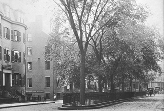
Louisburg Square is a street in the Beacon Hill neighborhood of Boston, Massachusetts, bisected by a small private park. The park is maintained by the Louisburg Square Proprietors. While the Proprietors pay taxes to the City of Boston, the city does not own the park or its garden.

State Street in Boston, Massachusetts, is one of the oldest streets in the city. Located in the financial district, it is the site of some historic landmarks, such as Long Wharf, the Old State House and the Boston Custom House.

Josiah Johnson Hawes (1808–1901) was a photographer in Boston, Massachusetts. He and Albert Southworth established the photography studio of Southworth & Hawes, which produced numerous portraits of exceptional quality in the 1840s–1860s.
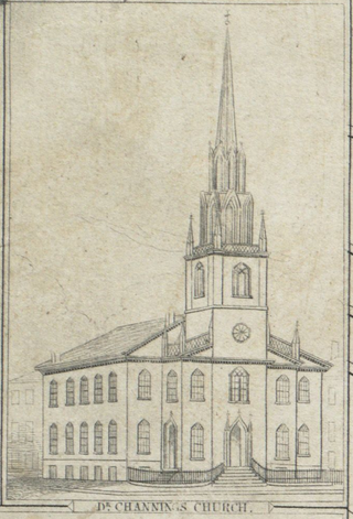
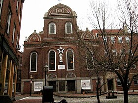
The Federal Street Church was a congregational Unitarian church in Boston, Massachusetts. Organized in 1727, the originally Presbyterian congregation changed in 1786 to "Congregationalism", then adopted the liberal theology of its fifth Senior Minister, William Ellery Channing, (1780–1842). For most of the 18th century the church was known as the Long Lane Meeting-House. In 1788, state leaders met in the relatively spacious building to determine Massachusetts' ratification of the United States Constitution. Thereafter the church renamed itself the Federal Street Church in honor of the event. In 1803, it called William Ellery Channing, (1780–1842), as its minister who defined "Unitarian Christianity" and launched the Unitarian movement, making the Federal Street Church one of the first to define itself as Unitarian.

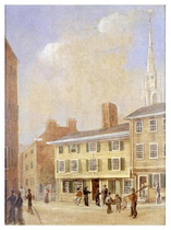
Federal Street is a street in the Financial District of Boston, Massachusetts. Prior to 1788, it was known as Long Lane. The street was renamed after state leaders met there in 1788 to determine Massachusetts' ratification of the United States Constitution.
Court Street is located in the Financial District of Boston, Massachusetts. Prior to 1788, it was called Prison Lane (1634–1708) and then Queen Street (1708–1788). In the 19th century it extended beyond its current length, to Bowdoin Square. In the 1960s most of Court Street was demolished to make way for the construction of Government Center. The remaining street extends a few blocks, near the Old State House on State Street.

Hanover Street is located in the North End of Boston, Massachusetts.

Brattle Street, which existed from 1694 to 1962, was a street in Boston, Massachusetts located on the current site of City Hall Plaza, at Government Center.

Congress Street in Boston, Massachusetts, is located in the Financial District and South Boston. It was first named in 1800. It was extended in 1854 as far as Atlantic Avenue, and in 1874 across Fort Point Channel into South Boston. Today's Congress Street consists of several segments of streets, previously named Atkinson's Street, Dalton Street, Gray's Alley, Leverett's Lane, Quaker Lane, and Shrimpton's Lane.

Dock Square in downtown Boston, Massachusetts, is a public square adjacent to Faneuil Hall, bounded by Congress Street, North Street, and the steps of the 60 State Street office tower. Its name derives from its original (17th-century) location at the waterfront. From the 1630s through the early 19th century, it served boats in the Boston Harbor as "the common landing place, at Bendell's Cove," later called Town Dock. "Around the dock was transacted the chief mercantile business of the town." After the waterfront was filled in during the early 19th century, Dock Square continued as a center of commerce for some years. The addition in the 1960s of Government Center changed the scale and character of the square from a hub of city life, to a place one merely passes through. As of the 1950s the square has become largely a tourist spot, with the Freedom Trail running through it.

William Clark was a merchant and town official in Boston, Massachusetts in the late 17th and early 18th centuries. Around 1713 he built a large house at North Square in Boston's North End.

Bowdoin Square in Boston, Massachusetts was located in the West End. In the 18th and 19th centuries it featured residential houses, leafy trees, a church, hotel, theatre and other buildings. Among the notables who have lived in the square: physician Thomas Bulfinch; merchant Kirk Boott; and mayor Theodore Lyman. The urban renewal project in the West End in the 1950s removed Green Street and Chardon Street, which formerly ran into the square, and renamed some existing streets; it is now a traffic intersection at Cambridge Street, Bowdoin Street, and New Chardon Street.
North Street in the North End of Boston, Massachusetts extends from Congress Street to Commercial Street. It runs past Dock Square, Faneuil Hall, Quincy Market, the Rose Kennedy Greenway, and North Square. It was first named in 1852, and consists of segments of streets formerly named Ann, Fish, Ship, Drawbridge, and Conduit Streets.

Merchants Row in Boston, Massachusetts is a short street extending from State Street to Faneuil Hall Square in the Financial District. Since the 17th century it has been a place of commercial activity. It sits close to Long Wharf and Dock Square, hubs of shipping and trade through the 19th century. Portions of the street were formerly known as Swing-Bridge Lane, Fish Lane, and Roebuck Passage.
Pemberton Square in the Government Center area of Boston, Massachusetts, was developed by P.T. Jackson in the 1830s as an architecturally uniform mixed-use enclave surrounding a small park. In the mid-19th century both private residences and businesses dwelt there. The construction in 1885 of the massive John Adams Courthouse changed the scale and character of the square, as did the Center Plaza building in the 1960s.

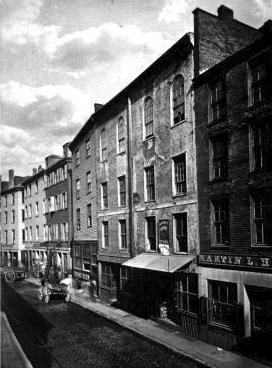
Cornhill was a street in Boston, Massachusetts, in the 18th, 19th and 20th centuries, located on the site of the current City Hall Plaza in Government Center. It was named in 1829; previously it was known as Market Street (1807–1828). In its time, it comprised a busy part of the city near Brattle Street, Court Street and Scollay Square. In the 19th century, it was the home of many bookstores and publishing companies. As of 1969, Cornhill exists as 144 feet along the edge of City Hall Plaza.

Tremont Row (1830s-1920s) in Boston, Massachusetts, was a short street that flourished in the 19th and early-20th centuries. It was located near the intersection of Court, Tremont, and Cambridge streets, in today's Government Center area. It existed until the 1920s, when it became known as Scollay Square. In 1859 the Barre Gazette newspaper described Tremont Row as "the great Dry Goods Street of Boston."