
Eastwood is a former coal mining town and civil parish in the Broxtowe district of Nottinghamshire, England, 8 miles (13 km) northwest of Nottingham. Mentioned in Domesday Book, it expanded rapidly during the Industrial Revolution. The Midland Railway was formed here and it is the birthplace of D. H. Lawrence.

Kimberley is a market town and civil parish in the Borough of Broxtowe in Nottinghamshire, England, lying 6 miles northwest of Nottingham along the A610. The town grew as a centre for coal mining, brewing and hosiery manufacturing. At the 2011 census the town had a population of 6,053, and this fell to 6,033 at the 2021 census.

Broxtowe is a local government district with borough status in Nottinghamshire, England. It lies immediately west of the city of Nottingham, and most of the built-up areas of the borough form part of the Nottingham Urban Area. The council is based in Beeston and the borough also includes the towns of Eastwood, Kimberley and Stapleford and surrounding villages and rural areas.
Chilwell is a suburban area in the borough of Broxtowe in Nottinghamshire, England. It lies on the west side of the town of Beeston and is 4 miles (6.4 km) south-west of the centre of Nottingham.

Radford is an inner-city area of Nottingham and former civil parish in the Nottingham district, in the ceremonial county of Nottinghamshire, England, located just outside the city centre. The appropriate ward of the City of Nottingham Council is Radford and Park which, in 2011, had a population of 21,414. It is bounded to the south by Lenton and to the east by Nottingham city centre, and comprises around 600 acres (240 ha) of land.

Broxtowe is a parliamentary constituency in Nottinghamshire, England, represented in the House of Commons of the UK Parliament since 2024 by Juliet Campbell, from the Labour Party.

Wollaton is a suburb and former civil parish in the western part of Nottingham, in the Nottingham district, in the ceremonial county of Nottinghamshire, England. Wollaton has two wards in the City of Nottingham, with a total population of 24,693 at the 2011 census. It is home to Wollaton Hall, with its museum, deer park, lake, walks and golf course.
Stapleford is a town and civil parish in the Borough of Broxtowe, Nottinghamshire, England, 6 miles (9.7 km) west of Nottingham. The population of the civil parish at the 2001 census was 14,991, at the 2011 census it was 15,241, and 15,453 at the 2021 census.

Strelley is a village and former civil parish in the Borough of Broxtowe and City of Nottingham in Nottinghamshire, England. It is to the west of Nottingham. The population of the civil parish taken at the 2011 census was 653, and 496 at the 2021 census. It is also the name of the nearby post war council housing estate. The village lies mainly in the Broxtowe district with a small portion crossing over into the city administrative area, whilst the estate is fully contained in the city of Nottingham. The village is separated from the housing estate by the A6002 road.

Aspley is a council estate and a ward of the city of Nottingham, Nottinghamshire, England. It is located within the boundaries of Nottingham City Council. The ward is located 3 miles (4.8 km) west of Nottingham City Centre and is located only 1.6 miles south-east of Junction 26 of the M1. It lies south of Bulwell, west of Basford and is north of Bilborough. The principal road in the ward is the A610. At the 2001 Census the ward had a population of 15,689, increasing to 17,622 at the 2011 census.

Greasley is a civil parish north west of Nottingham in Nottinghamshire, England. Although it is thought there was once a village called Greasley, there is no settlement of that name today as it was destroyed by the Earl of Rutland. The built up areas in the parish are Beauvale, Giltbrook, Moorgreen, Newthorpe, Watnall and parts of Eastwood, Kimberley and Nuthall. There is also a small hamlet known as Bog-End. The parish is one of the largest in Nottinghamshire at 7.63 square miles (19.8 km2), the 2001 UK Census reporting it had a total population of 10,467, increasing to 11,014 in 2011, and 11,241 at the 2021 census.

The A610 is an A-road in England, which runs from Nottingham to Ambergate, where it joins the A6.
Watnall is an area in the Borough of Broxtowe in Nottinghamshire, England. It is part of Greasley civil parish, and is located one mile north of Kimberley. It is in the Nuthall West and Greasley (Watnall) ward of Broxtowe Council. The village is barely separated from Nuthall. Watnall Hall was built c. 1690 and demolished in 1962. Today, only the gate piers, fragments of the stone boundary wall and lodge remain on Main Road. Its owners included Launcelot Rolleston in the 18th century. Even though only a village, Watnall is home to many businesses and organisations, such as British Bakeries and the Nottingham meteorological centre. There are three World War II bunkers in Watnall that served as Royal Air Force Fighter Command for the Midlands.
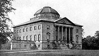
Nuthall Temple in Nottinghamshire, one of England's lost houses, was one of five houses built in the United Kingdom generally said to have been inspired by Palladio's Villa Capra in Vicenza.

Frogshall is a small hamlet within the civil parish of Northrepps in the English county of Norfolk. The hamlet is 5.2 miles (8.4 km) southeast of Cromer, 21.9 miles (35.2 km) north of Norwich and 136 miles (219 km) north of London. Craft Lane runs through the hamlet between Northrepps and Southrepps. The nearest railway station is at Gunton on the Bittern Line which runs between Sheringham, Cromer and Norwich. The nearest airport is Norwich International Airport. The hamlet as part of the greater parish of Northrepps had in the 2011 census, a population of 886. For the purposes of local government, the hamlet falls within the district of North Norfolk.

Strelley Estate is a post war housing estate located in the Bilborough ward in the City of Nottingham. The estate is located around 3.5 miles (6 km) from the city centre and lies west of the Broxtowe Estate, south of Nuthall, east of the Strelley Village and north of Bilborough. At the 2001 census, the estate had a population of 2,561.

Broxtowe is a council estate in the City of Nottingham which is part of the Aspley ward. The estate is located 3 miles (5 km) from the City Centre and lies west of Aspley and Cinderhill, south of Bulwell, east of Strelley and north of Bilborough. At the 2001 census, the estate had a population of 4,847.

Cinderhill is an area in the City of Nottingham. It is located roughly 3.1 miles (5.0 km) from the City Centre, and surrounding areas include Bulwell to the north, Aspley and Broxtowe to the south, Basford to the east and Nuthall to the west.
Nuthall is a civil parish in the Borough of Broxtowe, Nottinghamshire, England. The parish contains 15 listed buildings that are recorded in the National Heritage List for England. Of these, two are listed at Grade II*, the middle of the three grades, and the others are at Grade II, the lowest grade. The parish contains the village of Nuthall and the surrounding area. It once contained the country house of Nuthall Temple, but this was demolished in 1929. However, three buildings in its grounds have survived and are listed, namely, a summer house, a bridge and a gate pier. The other listed buildings consist of houses, cottages and associated structures, farmhouses and farm buildings, and a church and headstones in the churchyard.


