
A code talker was a person employed by the military during wartime to use a little-known language as a means of secret communication. The term is most often used for United States service members during the World Wars who used their knowledge of Native American languages as a basis to transmit coded messages. In particular, there were approximately 400 to 500 Native Americans in the United States Marine Corps whose primary job was to transmit secret tactical messages. Code talkers transmitted messages over military telephone or radio communications nets using formally or informally developed codes built upon their Indigenous languages. The code talkers improved the speed of encryption and decryption of communications in front line operations during World War II and are credited with a number of decisive victories. Their code was never broken.

The Hopi are Native Americans who primarily live in northeastern Arizona. The majority are enrolled in the Hopi Tribe of Arizona and live on the Hopi Reservation in northeastern Arizona; however, some Hopi people are enrolled in the Colorado River Indian Tribes of the Colorado River Indian Reservation at the border of Arizona and California.

Ganado is a chapter of the Navajo Nation and census-designated place (CDP) in Apache County, Arizona, United States. The population was 1,210 at the 2010 census.

Tuba City is an unincorporated town in Coconino County, Arizona, on the Navajo Nation, United States. It is the second-largest community in Coconino County. The population of the census-designated place (CDP) was 8,611 at the 2010 census.

Keams Canyon is a census-designated place (CDP) in Navajo County, Arizona, United States, on the Hopi Reservation. The population was 304 at the 2010 census.

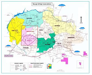
The Navajo Nation, also known as Navajoland, is a Native American reservation of Navajo people in the United States. It occupies portions of northeastern Arizona, northwestern New Mexico, and southeastern Utah. The seat of government is located in Window Rock, Arizona.

The Four Corners is a region of the Southwestern United States consisting of the southwestern corner of Colorado, southeastern corner of Utah, northeastern corner of Arizona, and northwestern corner of New Mexico. Most of the Four Corners region belongs to semi-autonomous Native American nations, the largest of which is the Navajo Nation, followed by Hopi, Ute, and Zuni tribal reserves and nations. The Four Corners region is part of a larger region known as the Colorado Plateau and is mostly rural, rugged, and arid.

An American Indian reservation is an area of land held and governed by a U.S. federal government-recognized Native American tribal nation, whose government is sovereign, subject to regulations passed by the United States Congress and administered by the United States Bureau of Indian Affairs, and not to the U.S. state government in which it is located. Some of the country's 574 federally recognized tribes govern more than one of the 326 Indian reservations in the United States, while some share reservations, and others have no reservation at all. Historical piecemeal land allocations under the Dawes Act facilitated sales to non–Native Americans, resulting in some reservations becoming severely fragmented, with pieces of tribal and privately held land being treated as separate enclaves. This jumble of private and public real estate creates significant administrative, political, and legal difficulties.

Diné College is a public tribal land-grant college based in Tsaile, Arizona, serving the 27,000-square-mile (70,000 km2) Navajo Nation. It offers associate degrees, bachelor's degrees, and academic certificates.

The Hopi Reservation is a Native American reservation for the Hopi and Arizona Tewa people, surrounded entirely by the Navajo Nation, in Navajo and Coconino counties in north-eastern Arizona, United States. The site has a land area of 2,531.773 sq mi (6,557.262 km²) and as of the 2000 census had a population of 6,946.
Peabody Energy mined coal at the Black Mesa plateau in the southwestern United States from the 1960s until 2019. The plateau overlaps the Navajo and Hopi reservations.
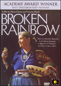
Broken Rainbow is a 1985 American documentary film by Victoria Mudd and Maria Florio.

Peterson Zah was an American politician who held several offices with the Navajo Nation. From 1983 to 1987, he was chairman of the Navajo Nation, its then head of government. At its 1991 restructuring, he became the first president of the Navajo Nation, until 1995. He then worked at Arizona State University as special adviser to the president on American Indian Affairs and consulted companies willing to work with his nation.

The Bureau of Indian Education (BIE), headquartered in the Main Interior Building in Washington, D.C., and formerly known as the Office of Indian Education Programs (OIEP), is a division of the U.S. Department of the Interior under the Assistant Secretary for Indian Affairs. It is responsible for the line direction and management of all BIE education functions, including the formation of policies and procedures, the supervision of all program activities, and the approval of the expenditure of funds appropriated for BIE education functions.
The Kayenta mine was a surface coal mine operated by Peabody Western Coal Company, a subsidiary of Peabody Energy) on the Navajo Nation in northern Arizona from 1973 to 2019. About 400 acres were mined and reclaimed each year, providing about 8 million tons of coal annually to the Navajo Generating Station.
The Bennett Freeze was a 43-year development ban on 1.5 million acres of Navajo lands by the US Federal Government. It was put in place in 1966 in order to promote negotiations over a land dispute between the Navajo and the Hopi and lasted until 2009. It was named for the Commissioner of Indian Affairs at the time, Robert L Bennett, and meant that in the "frozen" area, no development at all could occur. This included fixing roofs, building houses, constructing gas and water lines, and repairing roads.

Bears Ears National Monument is a United States national monument located in San Juan County in southeastern Utah, established by President Barack Obama by presidential proclamation on December 28, 2016. The monument protects 1,351,849 acres of public land surrounding the Bears Ears—a pair of buttes—and the Indian Creek corridor rock climbing area. The Native American names for the buttes have the same meaning in each of the languages represented in the region. The names are listed in the presidential proclamation as "Hoon’Naqvut, Shash Jáa [sic], Kwiyaghatʉ Nükavachi/Kwiyagatu Nukavachi, Ansh An Lashokdiwe"—all four mean "Bears Ears".
Katherine Smith (1918–2017) was a Navajo activist, cultural educator, land defender, and resistor who protected Navajo land and refused to leave Big Mountain. A 1985 documentary Broken Rainbow depicts the struggle of the Navajo amid government enforced relocation of thousands from Black Mesa in Arizona after the enactment of the Navajo-Hopi Land Settlement Act of 1974. The documentary film about the relocation was nominated for an Oscar.

On March 17, 2020, the COVID-19 pandemic was reported to have reached the Navajo Nation. The virus then spread rapidly through the Navajo Nation to the point that the Navajo, in 2020, had a higher per capita rate of infection than any state of the United States. The population according to the 2010 United States census was 173,667. As of September 13, 2022, the number of confirmed cases was 31,571 with 1,893 deaths.
Roberta Blackgoat was a Native American activist, public speaker, writer, environmentalist, and artist. Blackgoat is best known for her political activism in opposition to the American federal government's Navajo Relocation Program.