
Paradise is an unincorporated community and census-designated place (CDP) in Lancaster County, Pennsylvania, United States, with a ZIP code of 17562. The population was 1,129 at the 2010 census.

Johnson County is a county located in the U.S. state of Kentucky. As of the 2020 census, the population was 22,680. Its county seat is Paintsville. The county was formed in 1843 and named for Richard Mentor Johnson, a colonel of the War of 1812, United States Representative, Senator, and Vice President of the United States.
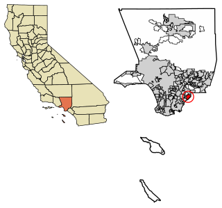
La Mirada is a city in southeast Los Angeles County, California United States, and is one of the Gateway Cities. The population was 48,527 at the 2010 census, up from 46,783 at the 2000 census. The La Mirada Theatre for the Performing Arts and the Splash! La Mirada Regional Aquatics Center are two of its major attractions. It is the home of Biola University, an evangelical Christian institution of higher education.
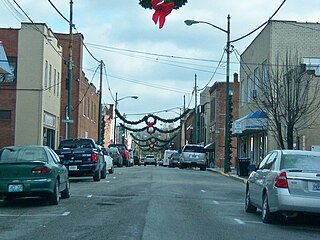
Paintsville is a home rule-class city along Paint Creek in Johnson County, Kentucky, in the United States. It is the seat of its county. The population was 6,459 during the 2010 U.S. Census.

Wauneta is a village in Chase County, Nebraska, United States. The population was 577 at the 2010 census. It lies along U.S. Route 6, southeast of the city of Imperial, the county seat of Chase County. Its elevation is 2,942 feet (897 m). Wauneta's ZIP code is 69045.

Spring Creek is a census-designated place (CDP) in central Elko County, in northeastern Nevada in the western United States. It mainly serves as a bedroom community for the businesses and industries in and around the nearby city of Elko. It is part of the Elko Micropolitan Statistical Area. The population was 12,361 at the 2010 census.

Medina is a city in and the county seat of Medina County, Ohio, United States. The population was 26,094 at the 2020 census. It lies about 33 miles (53 km) south of Cleveland and 23 miles (37 km) west of Akron within the Cleveland metropolitan area.

Mosheim is a town in Greene County, Tennessee, United States. The population was 2,479 at the 2020 census.

Cloverleaf is a census-designated place (CDP) in east central Harris County, Texas, United States. The population was 24,100 at the 2020 census.

Hilshire Village is a city in Harris County, Texas, United States. The population was 816 at the 2020 census. The city is the smallest of the Memorial Villages in terms of area.
Van Lear is an unincorporated community and coal town in Johnson County, Kentucky, United States.
Biddle is a village in southeastern Powder River County, Montana, United States, near the Little Powder River. It lies along Highway 59, south of the town of Broadus, the county seat of Powder River County. Its elevation is 3,337 feet (1,017 m). It offers basic services not only to the community, but those that are passing through as well: a mercantile store with gas pumps, lodging through the mercantile, a post office, a one-room school accommodating grades K-8, a volunteer fire department and a small church.
Hager Hill (also Hagerhill) is an unincorporated community in Johnson County, Kentucky, United States. Hager Hill is located approximately four miles south of Paintsville, the county seat of Johnson County.
Cerulean is a census-designated place and unincorporated community in Trigg and Christian counties, Kentucky, United States. At one time, it was a city, incorporated as Cerulean Springs. It lies along Kentucky Routes 124 and 126 northeast of the city of Cadiz, the county seat of Trigg County. Its elevation is 512 feet (156 m), and it is located at 36°57′34″N87°42′36″W. It has a post office with the ZIP code 42215.
Little Cedar is an unincorporated community and census-designated place in central Mitchell County, Iowa, United States. As of the 2020 census it had a population of 64. Little Cedar has a post office with the ZIP code of 50454.
Tutor Key is an unincorporated community in Johnson County, Kentucky, United States about 4.5 miles northeast of Paintsville. Tutor Key was originally known as Mingo.
Staffordsville is an unincorporated community in Johnson County, Kentucky, United States. The community was originally named Frew and the first post office was established on July 14, 1882, with Millard F. Rule as postmaster but in 1893, postmistress Jessie Stafford changed the post office's name to "Staffordsville" in order to honor her family. Staffordsville's ZIP code is 41256.

Thealka is an unincorporated community in Johnson County, Kentucky, United States. It was created by the North East Coal Company in 1906.and was originally called Muddy Branch. In 1911, it was renamed "Thealka" after the steamboat known by the same name. Both the community and the steamboat were named after John C.C. Mayo's wife, Alice Jane Mayo, who was given the nickname "Alka". Thealka is in the 41240 ZIP Code Tabulation Area, which includes the nearby city of Paintsville.
Flat Gap is an unincorporated community in Johnson County, Kentucky, United States. The community was named after the "flat gap" formed at the divide between the Lower Laurel and Mudlick Creeks. Flat Gap's first post office was established on February 26, 1873, with Henry Jayne as postmaster. Its ZIP code is 41219.
Wittensville is an unincorporated community in Johnson County, Kentucky, United States. Wittensville's ZIP code is 41274. It has a United States Postal Service, which stands besides a Dollar General which was constructed in June 2019. It also has an East Kentucky Realty estate agency.


