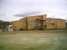
Yellowknife Airport is located in Yellowknife, Northwest Territories, Canada. The airport is part of the National Airports System, and is operated by the Government of the Northwest Territories. The airport has regular scheduled passenger service and a number of freight services. In 2007, the terminal handled 527,000 passengers.

Erik Nielsen Whitehorse International Airport is an international airport located in Whitehorse, Yukon, Canada. It is part of the National Airports System, and is owned and operated by the Government of Yukon. The airport was renamed in honour of longtime Yukon Member of Parliament Erik Nielsen on December 15, 2008. The terminal handled 294,000 passengers in 2012, representing a 94% increase in passenger traffic since 2002. By 2017, this number had risen to 366,000. Air North is based in Whitehorse.

Beaver Creek Airport is located 1 nautical mile northwest of Beaver Creek, Yukon, Canada, and is operated by the Yukon government. The gravel runway is 3,745 by 100 ft, and is at an elevation of 2,131 ft (650 m).

Dawson City Airport is located 8 nautical miles east of Dawson City, Yukon, Canada, in the Klondike River valley, and is operated by the Yukon government. It has a terminal building and a runway which was paved in May 2019. The asphalt runway is 5,003 ft × 100 ft long and at an elevation of 1,215 ft (370 m). A number of studies have recommended moving the airport or realigning the runway as it is in a narrow mountain valley.

Faro Airport is located 1.5 nautical miles south of Faro, Yukon, Canada, and is operated by the Yukon government. The gravel runway is 3,997 ft (1,218 m) long and is at an elevation of 2,350 ft (716 m).

Teslin Airport is located on the northwest side of Teslin, Yukon, Canada, and is operated by the Yukon government. The gravel runway is 5,000 ft (1,524 m) long and is at an elevation of 2,313 ft (705 m).

Watson Lake Airport is located 5 nautical miles west of Watson Lake, Yukon, Canada, and is operated by the Yukon government. The paved asphalt runway is 5,500 ft (1,676 m) long and is at an elevation of 2,255 ft (687 m).

The West Kootenay Regional Airport is a small regional airport located 2 nautical miles south southeast of Castlegar, British Columbia, Canada. It serves the West Kootenay region, including Castlegar, Nelson and Trail. It is owned and operated by the City of Castlegar, and has a 15,317 sq ft (1,423 m2) passenger terminal.

Cranbrook/Canadian Rockies International Airport is an international airport located 5 nautical miles north of Cranbrook and 20 km (12 mi) south-east of Kimberley, British Columbia, in the Canadian Rockies.

Fort St. John Airport, North Peace Regional Airport, or North Peace Airport, is located at Fort St. John, British Columbia, Canada. The airport is operated by North Peace Airport Services Ltd. A new record of 257,295 passengers came through the airport in 2015, up from the 252,729 passengers seen in 2014.

Sept-Îles Airport is situated 4.5 nautical miles east of the town of Sept-Îles, Quebec, Canada.

Dawson City Water Aerodrome(TC LID: CEG7) was located adjacent to Dawson City, Yukon, Canada and was open from August to September.

Kenora Airport is located 5 nautical miles east northeast of Kenora, Ontario, Canada. The airport is classified as an airport of entry by Nav Canada and is staffed by the Canada Border Services Agency (CBSA) on a call-out basis from the Fort Frances-International Falls International Bridge. CBSA officers at this airport can handle general aviation aircraft with no more than 15 passengers. The airport has one asphalt runway that is 5,800 by 150 ft. The airport is under Aircraft Group Number (AGN) classification of IV.

Thompson Municipal Airport is an airport in Mystery Lake located 3 nautical miles north of Thompson, Manitoba, Canada. It is the third-busiest airport in Manitoba after Winnipeg James Armstrong Richardson International Airport and Winnipeg/St. Andrews Airport.

Northern Rockies Regional Airport is located 3.8 nautical miles east northeast of Fort Nelson, British Columbia, Canada.

Coronach/Scobey Border Station Airport is located 8 nautical miles southeast of Coronach, Saskatchewan, Canada and 13 mi (21 km) north of Scobey, Montana, United States. In the United States, the airport is known by the names Scobey Border Station Airport and East Poplar International Airport. It is owned by the U.S. and Canadian governments.

Port Hardy Airport is located 5.2 nautical miles southeast of Port Hardy, British Columbia, Canada.

Smithers Airport is 2 nautical miles north of Smithers, British Columbia, Canada.

Whitehorse Water Aerodrome is located on Schwatka Lake, 2 nautical miles south of Whitehorse, Yukon, Canada.


