Olímpia

Last updated • 3 min readFrom Wikipedia, The Free Encyclopedia
Olímpia
The Municipality of
Olímpia
Olimpia, SP.jpg
Olímpia skyline
Bandeira de Olimpia.svg
Brasao de Olimpia, SP.jpg
Nickname(s): 
Folklore's National Capital, The Lady Girl City
SaoPaulo Municip Olimpia.svg
Location of Olímpia
Coordinates: 20°44′14″S48°54′53″W / 20.73722°S 48.91472°W / -20.73722; -48.91472
CountryFlag of Brazil.svg  Brazil
Region Southeast
State Bandeira do estado de Sao Paulo.svg  São Paulo
Mesoregion São José do Rio Preto
Government
  MayorEugênio José Zuliani
Area
  Total
802.6 km2 (309.9 sq mi)
Elevation
506 m (1,660 ft)
Population
 (2020 [1] )
  Total
55,130
  Density62.32/km2 (161.4/sq mi)
Time zone UTC−3 (BRT)
Postal Code
15400-000
Area code +55 17
Website Olímpia's Prefecture

Olímpia is a municipality in the state of São Paulo, Brazil, in the Microregion of São José do Rio Preto. As of the 2020 census, the population of the city was 55,130 inhabitants. The city has a total area of 802.6 km2 (309.9 sq mi).

Contents

History

The oldest archaeological evidence in the territory dates back to the centuries 9th or 10th. In the early 1990s, workers of construction found four funerary urns containing bones, bead necklaces, and pots inside, which was later linked to the Tupi, and Macro Je people. Although it is known that Latin America was inhabited by nomadic tribes, this is actually the oldest evidence of human presence in the area prior to European colonization. [2] [3]

In the 19th century, the foundation of Olimpia (formerly knows as Fazenda Olhos d'Água, and then, Vila Olímpia) is related to the coffee industry during the Empire of Brazil, when plantation owners meet the demand of labor. [4]

With the exhaustion of the gold mines, people abandoned their previous sites in search of a better one. The new settlers focus on the unexplored areas to dedicate themselves to agriculture and cattle raising.[ citation needed ]

The first reports indicate that a farmer named ''Antônio Joaquim dos Santos'' was the first settler to establish a farm in the 19th century. He named his property as ''Fazenda Olhos D'Água'' (Portuguese for ''Water holes farm'') due to the amount of water springs in the area. [5]

The increasing numbers of migrant colonials settling in the area and the need for a collectivized farming led the local community the decision to create the village. [6] In 1903, the landowners invitated the English immigrants Robert John Reid, and William Leatherbarrow, to separate the lands and establish the city. [7]

The town was elevated to a district of Barretos on December 18, 1906, and named as "Vila Olímpia" in honor to Maria Olímpia Rodrigues Vieira, who was the daughter of Antônio Olímpio Rodrigues Vieira. Vieira was one of the founders of the city.

Nowadays, a range of buildings reveal the timeline of Olimpia's history and were declared historical landmarks, such as the old railway station, and the first hospital of the city ''Beneficiência Portuguesa''. [8]

The city was separated from Barretos on December 7, 1917. [9]

In July 2014, it was approved by the São Paulo State Legislative Assembly, a bill that turned Olímpia into a Touristic Municipality. [10]

Toponym

The name of the city comes from ''Maria Olímpia Rodrigues Vieira'', daughter of one of the men who founded the city.

Economy

The service sector is the largest employer. Trade and Services accounted 65.5%, followed by the Industry representing 26% and the primary sector accounting 8.2% of the GDP. [11]

Thermas dos Laranjais

Olimpia is home to Thermas dos Laranjais water park, one of the most visited water parks in the world. The park was opened in 1987 and is home to the largest complex of thrilling waterslides in Brazil occupying an area of 358.797 sq. yd. (300 km2). [12]

It boasts more than 55 attractions. These include waterslides, surfing facilities, pools, rivers, and family-friendly offerings. [13]

According to Themed Entertainment Association (TEA), by 2019 the park received 1.8 million visitors. [14]

Culture

Olímpia is known as ''The capital of Folklore'' promoting every year the National Folklore Festival of Olimpia, when Brazilian folklore groups meet themselves to perform on stage their local dances ranging from Gaucho tradition groups to Amazonian dances. [15]

Media

In telecommunications, the city was served by Companhia Telefônica Brasileira until 1973, when it began to be served by Telecomunicações de São Paulo. [16] In July 1998, this company was acquired by Telefónica, which adopted the Vivo brand in 2012. [17]

The company is currently an operator of cell phones, fixed lines, internet (fiber optics/4G) and television (satellite and cable). [17]

Sports

The city is home to Olímpia Futebol Clube.

Transportation

Religion

Christianity is present in the city as follows:

Catholic Church

The Catholic church in the municipality is part of the Roman Catholic Diocese of Barretos. [18]

Protestant Church

The most diverse evangelical beliefs are present in the city, mainly Pentecostal, including the Assemblies of God in Brazil (the largest evangelical church in the country), [19] [20] Christian Congregation in Brazil, [21] among others. These denominations are growing more and more throughout Brazil.

See also

Related Research Articles

<span class="mw-page-title-main">Barretos</span> Municipality in the state of São Paulo in Brazil

Barretos is a municipality in the northern part of the state of São Paulo, Brazil. The city has approximately 122,833 inhabitants (IBGE/2020) and an area of 1566.1 km2. Barretos belongs to the Mesoregion of Ribeirão Preto.

<span class="mw-page-title-main">Araras</span> Municipality in Brazil

Araras is a municipality located in the interior of State of São Paulo, Brazil. The population is 135,506 as of the 2020 IBGE estimate.

<span class="mw-page-title-main">Barueri</span> Municipality in Southeast, Brazil

Barueri is a Brazilian municipality in the State of São Paulo located in the northwestern part of the Metropolitan Region of São Paulo. The population is 276,982 in an area of 65.70 km2 (25.37 sq mi).

<span class="mw-page-title-main">Artur Nogueira</span> Municipality in the state of São Paulo in Brazil

Artur Nogueira is a city in the state of São Paulo in Brazil. It is part of the Metropolitan Region of Campinas. The population is 55,340 in an area of 178.03 km2. The elevation is 595 m.

<span class="mw-page-title-main">Bady Bassitt</span> Municipality in Southeast, Brazil

Bady Bassitt is a municipality in the state of São Paulo, Brazil. The population is 27,260 in an area of 110 km². The town is located 7 km from São José do Rio Preto, and the municipality belongs to the Microregion of São José do Rio Preto.

<span class="mw-page-title-main">São Pedro, São Paulo</span> Municipality in Southeast, Brazil

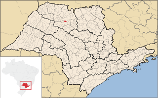
São Pedro is a municipality in the state of São Paulo in Brazil. The population is of 35,980 (2020) in an area of 611.278 km2 (236.02 sq mi).

<span class="mw-page-title-main">Fernandópolis</span> Municipality in Southeast, Brazil

Fernandópolis is a municipality in the state of São Paulo, Brazil. The population is 71,186 in an area of 550 km2. Fernandópolis is the center of the microregion of Fernandópolis with 104,623 inhabitants and area of 2,811.7 km2.

<span class="mw-page-title-main">Holambra</span> Municipality in Southeast Brazil, Brazil

Holambra is a municipality in the state of São Paulo in Brazil. It is part of the Metropolitan Region of Campinas. Holambra is the largest producer of flowers and ornamental plants in Latin America, also hosting the largest spring event in the continent, the Expoflora. The population is 15,272 in an area of 65.58 km2. The elevation is 600m on average.

<span class="mw-page-title-main">Iacri</span> Municipality in Southeast, Brazil

Iacri is a municipality in the state of São Paulo in Brazil. The population is 6,295 in an area of 322 km². The elevation is 499 m.

<span class="mw-page-title-main">Jales</span> Municipality in Southeast, Brazil

Jales is a municipality in the state of São Paulo, Brazil. The population in 2020, according to the IBGE, is 49,201 inhabitants. The city is located 601 km from the city of São Paulo.

<span class="mw-page-title-main">Lucélia</span> Municipality in Southeast, Brazil

Lucélia is a municipality in the state of São Paulo in Brazil. The population is 21,886 in an area of 315 km². The elevation is 438 m.

<span class="mw-page-title-main">Mirassol</span> Municipality in Southeast, Brazil

Mirassol is a municipality in the state of São Paulo, Brazil. The city is located in the northern part of the state, 453 km from the city of São Paulo and 15 km from São José do Rio Preto. Mirassol has 60,303 inhabitants (IBGE/2020).

<span class="mw-page-title-main">Nhandeara</span> Municipality in Southeast, Brazil

Nhandeara is a municipality in the state of São Paulo, Brazil. The city has a population of 11,527 inhabitants and an area of 435.8 km².

<span class="mw-page-title-main">Nova Odessa</span> Municipality in Southeast, Brazil

Nova Odessa is a Brazilian municipality in the state of São Paulo. It is part of the Metropolitan Region of Campinas. The population is 60,956 in an area of 73.79 km2. Nova Odessa was founded on May 24, 1905, by Carlos José de Arruda Botelho, Secretary of Agriculture of the state of São Paulo, and then settled by Ukrainians and Latvians.

<span class="mw-page-title-main">Paraguaçu Paulista</span> Municipality in Southeast, Brazil

Paraguaçu Paulista is a municipality in south-west of the state of São Paulo in Brazil. It is part of the Microregion of Assis, situated in the middle Paranapanema Valley. The population is 45,945 in an area of 1001.3 km2. It's the second largest population of microregion and the 3rd of mesoregion, and is 422 km away from the capital, São Paulo.

<span class="mw-page-title-main">Pereira Barreto</span> Municipality in Brazil

Pereira Barreto is a municipality in the state of São Paulo in Brazil. The population is 25,677 in an area of 974 km². The elevation is 347 meters.

<span class="mw-page-title-main">Pompeia, São Paulo</span> Municipality in Southeast, Brazil

Pompeia is a municipality in the state of São Paulo in Brazil. The population is 22,172 (2020) within an area of 784 km2. In 2000, its Human Development Index was 0.816.

<span class="mw-page-title-main">São Luiz do Paraitinga</span> Municipality in Southeast, Brazil

Paraitinga River

<span class="mw-page-title-main">Tanabi</span> Municipality in Southeast, Brazil

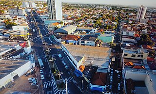
Tanabi is a municipality in the northwestern part of the state of São Paulo, Brazil. The population is 26,101 inhabitants (IBGE/2020). The city is located 447 km from the city of São Paulo and 30 km from São José do Rio Preto. Tanabi was founded on July 4, 1882.

<span class="mw-page-title-main">Álvares Florence</span> Municipality in Southeast, Brazil

Álvares Florence is a municipality in the state of São Paulo, Brazil. It has a population of 3,647 inhabitants (IBGE/2020) and an area of 362.9 km2.

References

  1. "IBGE 2020". cidades.ibge.gov.br. Retrieved 2024-03-24.
  2. "Cemitério Maranata está registrado pelo IPHAN em 1997". iFolha (in Brazilian Portuguese). 2014-10-21. Retrieved 2022-03-11.
  3. "MPF/SP recomenda preservação de sítio arqueológico em Olímpia". Jusbrasil (in Brazilian Portuguese). Retrieved 2022-03-11.
  4. Eakin, Marshall C. (1998-09-15). Brazil: The Once and Future Country. Palgrave Macmillan. ISBN   978-0-312-21445-6.
  5. "História de Olímpia". Prefeitura da Estância Turística de Olímpia-SP (in Brazilian Portuguese). Retrieved 2022-03-11.
  6. "Olímpia (São Paulo) – Acervo Lima". wiki.acervolima.com. Retrieved 2022-03-09.
  7. "Facesp - Federação das Associações Comercias do Estado de São Paulo". www.facesp.com.br. Retrieved 2022-03-11.
  8. "Facesp - Federação das Associações Comercias do Estado de São Paulo". www.facesp.com.br. Retrieved 2022-03-11.
  9. "History of the City" (in Portuguese). Olimpia.sp.gov.br. Retrieved 2011-07-09.
  10. "Prefeitura da Estância Turística de Olímpia-SP". Prefeitura da Estância Turística de Olímpia-SP (in Brazilian Portuguese). Retrieved 2022-03-11.
  11. "Municipal Profile at SEADE" (in Portuguese). Fundação SEADE. Archived from the original on 2011-08-23. Retrieved 2011-07-08.
  12. Newby, Johnny (2019-07-29). "Thermas dos Laranjais". The Travel Hacking Life. Retrieved 2022-03-11.
  13. "'Brazilian Orlando' Hopes to Set a Record of 750,000 Tourists this Summer". Folha de S.Paulo. 2022-01-05. Retrieved 2022-03-11.
  14. "The top 17 water parks in the world". Blooloop. 2021-04-15. Retrieved 2022-03-11.
  15. "Festival do Folclore de Olímpia - SP". Festival do Folclore de Olímpia - SP (in Brazilian Portuguese). Retrieved 2022-03-11.
  16. "Creation of Telesp - April 12, 1973". www.imprensaoficial.com.br (in Portuguese). Retrieved 2024-05-26.
  17. 1 2 "Our History - Telefônica RI". Telefônica. Retrieved 2024-05-26.
  18. "Sul 1 Region of Brazil [Catholic-Hierarchy]". www.catholic-hierarchy.org. Retrieved 2024-07-21.
  19. "Campos Eclesiásticos". CONFRADESP (in Portuguese). 2018-12-10. Retrieved 2024-07-21.
  20. "Arquivos: Locais". Assembleia de Deus Belém – Sede (in Portuguese). Retrieved 2024-07-21.
  21. "Localidade - Congregação Cristã no Brasil". congregacaocristanobrasil.org.br (in Portuguese). Retrieved 2024-07-21.