Bady Bassitt

Last updated • 2 min readFrom Wikipedia, The Free Encyclopedia
Bady Bassitt
Bandeira BadyBassit SaoPaulo Brasil.svg
Brasao BadyBassit SaoPaulo Brasil.svg
SaoPaulo Municip BadyBassitt.svg
Location in São Paulo state
Brazil location map.svg
Red pog.svg
Bady Bassitt
Location in Brazil
Coordinates: 20°55′5″S49°26′43″W / 20.91806°S 49.44528°W / -20.91806; -49.44528
Country Brazil
Region Southeast
State São Paulo
Mesoregion São José do Rio Preto
Microregion São José do Rio Preto
Government
   Mayor LUIZ ANTÔNIO TOBARDINI
Area
  Total
110 km2 (40 sq mi)
Elevation
510 m (1,670 ft)
Population
 (2022)<ref>https://www.ibge.gov.br/cidades-e-estados/sp/bady-bassitt.html {{Bare URL inline|date=August 2024}}</ref> tags
  Total
27,260
Demonym Badiense
Time zone UTC−3 (BRT)
Postal code
15115-000
Area code +55 17
Website www.badybassitt.sp.gov.br

Bady Bassitt is a municipality in the state of São Paulo, Brazil. The population is 27,260 (2022 est.) in an area of 110 km². [1] The town is located 7 km from São José do Rio Preto, and the municipality belongs to the Microregion of São José do Rio Preto.

Contents

History

In 1908, Bady Bassitt was a village named Borboleta (butterfly). In this year, a road coming from Rio Preto was open. Camilo de Morais opened the first store in Borboleta, in 1912.

On February 13, 1914, the village of Borboleta was officially established, and on December 12, 1926, the village was elevated to district of Rio Preto.

On February 18, 1959, the municipality of Borboleta is officially established, and in 1963, the name was changed to the current form, an homage to Bady Bassitt, a politician from São José do Rio Preto. [2]

Geography

Neighbouring places

Hydrography

The municipality features several streams:

Demographics

Population history

YearPopulation
200011,550
201014,603
201516,359

Statistics

All statistics are from SEADE [3] and IBGE. [4]

Economy

The Tertiary sector is the economic basis of Bady. Commerce, services and administration corresponds to 60.5% of the city GDP. Industry is 35.2% of the GDP, and the Primary sector corresponds to 4.1%. [3]

Media

In telecommunications, the city was served by Telecomunicações de São Paulo. [5] In July 1998, this company was acquired by Telefónica, which adopted the Vivo brand in 2012. The company is currently an operator of cell phones, fixed lines, internet (fiber optics/4G) and television (satellite and cable). [6]

Transportation

The city is linked with the BR-153 (Transbrasiliana), the SP-310 (in Rio Preto) and the SP-355 (Maurício Goulart) highways.

See also

Related Research Articles

<span class="mw-page-title-main">São José do Rio Preto</span> Municipality in southeast Brazil

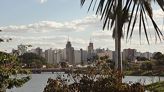
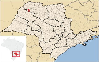
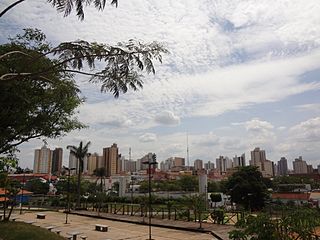
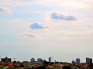
São José do Rio Preto is a municipality in the state of São Paulo, Brazil. It is located in the northwestern region of the state, approximately 440 km (270 mi) from the city of São Paulo and 700 km (430 mi) from Brasília. With a population of 469,173 inhabitants as of the 2021 census, it is the 11th largest city in São Paulo and the 36th largest in Brazil.

<span class="mw-page-title-main">Auriflama</span> Municipality in the state of São Paulo in Brazil

Auriflama is a municipality in the state of São Paulo, Brazil. The population is 15,253 in an area of 434.3 km2. Auriflama belongs to the Mesoregion of São José do Rio Preto.

<span class="mw-page-title-main">Catanduva</span> Municipality in São Paulo, Brazil

Catanduva is a municipality in the state of São Paulo, Brazil. The population is 122,497 in an area of 290.59 km2. Is the second largest city in the Northern part of the state, after São José do Rio Preto. The city has a diversified economy, and the cultivation and processing of sugarcane is relevant.

<span class="mw-page-title-main">Fernandópolis</span> Municipality in Southeast, Brazil

Fernandópolis is a municipality in the state of São Paulo, Brazil. The population is 71,186 in an area of 550 km2. Fernandópolis is the center of the microregion of Fernandópolis with 104,623 inhabitants and area of 2,811.7 km2.

<span class="mw-page-title-main">Guapiaçu</span> Municipality in Southeast, Brazil

Guapiaçu is a municipality in the state of São Paulo, Brazil, with a population, measured in 2020 by the IBGE, of 21,775 and an area of 326 km2 (126 sq mi). Is located in the north/northwest of the state, 17 kilometres (11 mi) from São José do Rio Preto.

<span class="mw-page-title-main">Jales</span> Municipality in Southeast, Brazil

Jales is a municipality in the state of São Paulo, Brazil. The population in 2020, according to the IBGE, is 49,201 inhabitants. The city is located 601 km from the city of São Paulo.

<span class="mw-page-title-main">José Bonifácio, São Paulo</span> Municipality in Southeast, Brazil

José Bonifácio is a municipality in the state of São Paulo, Brazil. The population is of 37,366 inhabitants and the area is 859.94 km2. The city belongs to the Microregion of São José do Rio Preto.

<span class="mw-page-title-main">Mirassol</span> Municipality in Southeast, Brazil

Mirassol is a municipality in the state of São Paulo, Brazil. The city is located in the northern part of the state, 453 km from the city of São Paulo and 15 km from São José do Rio Preto. Mirassol has 60,303 inhabitants (IBGE/2020).

<span class="mw-page-title-main">Monte Aprazível</span> Municipality in Southeast, Brazil

Monte Aprazível is a municipality in the state of São Paulo, Brazil. The population is of 25,373 inhabitants, and the area is 496.9 km2.

<span class="mw-page-title-main">Nhandeara</span> Municipality in Southeast, Brazil

Nhandeara is a municipality in the state of São Paulo, Brazil. The city has a population of 11,527 inhabitants and an area of 435.8 km².

<span class="mw-page-title-main">Nova Granada</span> Municipality in Southeast, Brazil

Nova Granada is a municipality in the northern part of the state of São Paulo, Brazil. The population is 21,689 inhabitants (IBGE/2020), and the area is 533.49 km2. The elevation is 542 m.

<span class="mw-page-title-main">Novo Horizonte, São Paulo</span> Municipality in Southeast, Brazil

Novo Horizonte is a municipality in the state of São Paulo, Brazil. The population is 41,414 in an area of 932 km2. Novo Horizonte is the center of a Microregion with 79,222 inhabitants.

<span class="mw-page-title-main">Palestina, São Paulo</span> Municipality in Southeast, Brazil

Palestina is a municipality (município) in the state of São Paulo, Brazil. The population is 13,123 in an area of 696.6 km2.

<span class="mw-page-title-main">Pindorama, São Paulo</span> Municipality in Southeast, Brazil

Pindorama is a municipality in the state of São Paulo, Brazil. The name is Tupi for Land of the Palms, the natives name for Brazil. According to tradition, before colonisation "Pindorama" was the native name of Brazil, given by the local indigenous peoples.

<span class="mw-page-title-main">Potirendaba</span> Municipality in Southeast, Brazil

Potirendaba is a municipality in the state of São Paulo, Brazil. The city has 17,516 inhabitants (IBGE/2020) and an area of 342.4 km2.

<span class="mw-page-title-main">Tanabi</span> Municipality in Southeast, Brazil

Tanabi is a municipality in the northwestern part of the state of São Paulo, Brazil. The population is 26,101 inhabitants (IBGE/2020). The city is located 447 km from the city of São Paulo and 30 km from São José do Rio Preto. Tanabi was founded on July 4, 1882.

<span class="mw-page-title-main">Álvares Florence</span> Municipality in Southeast, Brazil

Álvares Florence is a municipality in the state of São Paulo, Brazil. It has a population of 3,647 inhabitants (IBGE/2020) and an area of 362.9 km2.

<span class="mw-page-title-main">Santa Adélia</span> Municipality in Southeast, Brazil

Santa Adélia is a municipality in the state of São Paulo, Brazil. The city has a population of 15,561 inhabitants and an area of 330.9 km². Santa Adélia belongs to the Mesoregion of São José do Rio Preto.

<span class="mw-page-title-main">Santa Fé do Sul</span> Municipality in Southeast, Brazil

Santa Fé do Sul is a municipality in the state of São Paulo, Brazil. The population is of 32,563 (IBGE/2020) and the area is 208.2 km2.

<span class="mw-page-title-main">Uchoa</span> Municipality in Southeast, Brazil

Uchoa is a municipality in the state of São Paulo, Brazil. The population is of 10,151 inhabitants and the area is 252.5 km2. Uchoa belongs to the Mesoregion of São José do Rio Preto.

References

  1. Instituto Brasileiro de Geografia e Estatística
  2. "History of the City on the Prefecture Site". Badybassitt.sp.gov.br. Archived from the original on 6 July 2011. Retrieved 15 July 2011.
  3. 1 2 "Municipal Profile at SEADE". SEADE.gov.br. Archived from the original on 23 August 2011. Retrieved 15 July 2011.
  4. "Population at "Censo 2010"" (PDF) (in Portuguese). IBGE.gov.br. Retrieved 7 Jul 2011.
  5. "Creation of Telesp - April 12, 1973". www.imprensaoficial.com.br (in Portuguese). Retrieved 2024-06-04.
  6. "Our History - Telefônica RI". Telefônica. Retrieved 2024-06-04.