
The Willamette River is a major tributary of the Columbia River, accounting for 12 to 15 percent of the Columbia's flow. The Willamette's main stem is 187 miles (301 km) long, lying entirely in northwestern Oregon in the United States. Flowing northward between the Oregon Coast Range and the Cascade Range, the river and its tributaries form the Willamette Valley, a basin that contains two-thirds of Oregon's population, including the state capital, Salem, and the state's largest city, Portland, which surrounds the Willamette's mouth at the Columbia.
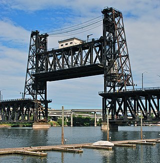
The Steel Bridge is a through truss, double-deck vertical-lift bridge across the Willamette River in Portland, Oregon, United States, opened in 1912. Its lower deck carries railroad and bicycle/pedestrian traffic, while the upper deck carries road traffic, and light rail (MAX), making the bridge one of the most multimodal in the world. It is the only double-deck bridge with independent lifts in the world and the second oldest vertical-lift bridge in North America, after the nearby Hawthorne Bridge. The bridge links the Rose Quarter and Lloyd District in the east to Old Town Chinatown neighborhood in the west.

Multnomah Falls is a waterfall located on Multnomah Creek in the Columbia River Gorge, east of Troutdale, between Corbett and Dodson, Oregon, United States. The waterfall is accessible from the Historic Columbia River Highway and Interstate 84. Spanning two tiers on basalt cliffs, it is the tallest waterfall in the state of Oregon at 620 ft (189 m) in height. The Multnomah Creek Bridge, built in 1914, crosses below the falls, and is listed on the National Register of Historic Places.

The Historic Columbia River Highway is an approximately 75-mile-long (121 km) scenic highway in the U.S. state of Oregon between Troutdale and The Dalles, built through the Columbia River Gorge between 1913 and 1922. As the first planned scenic roadway in the United States, it has been recognized in numerous ways, including being listed on the National Register of Historic Places, being designated as a National Historic Landmark by the U.S. Secretary of the Interior, being designated as a National Historic Civil Engineering Landmark by the American Society of Civil Engineers, and being considered a "destination unto itself" as an All-American Road by the U.S. Secretary of Transportation. The historic roadway was bypassed by the present Columbia River Highway No. 2 from the 1930s to the 1950s, leaving behind the old two-lane road. The road is now mostly owned and maintained by the state through the Oregon Department of Transportation as the Historic Columbia River Highway No. 100 or the Oregon Parks and Recreation Department as the Historic Columbia River Highway State Trail.

Bonneville Lock and Dam consists of several run-of-the-river dam structures that together complete a span of the Columbia River between the U.S. states of Oregon and Washington at River Mile 146.1. The dam is located 40 miles (64 km) east of Portland, Oregon, in the Columbia River Gorge. The primary functions of Bonneville Lock and Dam are electrical power generation and river navigation. The dam was built and is managed by the United States Army Corps of Engineers. At the time of its construction in the 1930s it was the largest water impoundment project of its type in the nation, able to withstand flooding on an unprecedented scale. Electrical power generated at Bonneville is distributed by the Bonneville Power Administration. Bonneville Dam is named for Army Capt. Benjamin Bonneville, an early explorer credited with charting much of the Oregon Trail. The Bonneville Dam Historic District was designated a National Historic Landmark District in 1987.

The Hawthorne Bridge is a truss bridge with a vertical lift that spans the Willamette River in Portland, Oregon, joining Hawthorne Boulevard and Madison Street. It is the oldest vertical-lift bridge in operation in the United States and the oldest highway bridge in Portland. It is also the busiest bicycle bridge in Oregon, with over 8,000 cyclists and 800 TriMet buses daily. It was added to the National Register of Historic Places in November 2012.

The Sellwood Bridge is a deck arch bridge that spans the Willamette River in Portland, Oregon, in the United States. The current bridge opened in 2016 and replaced a 1925 span that had carried the same name. The original bridge was Portland's first fixed-span bridge and, being the only river crossing for miles in each direction, the busiest two-lane bridge in Oregon.

The Rainbow Bridge and Veterans Memorial Bridge are two bridges that cross the Neches River in Southeast Texas just upstream from Sabine Lake. It allows State Highway 87 and State Highway 73 to connect Port Arthur in Jefferson County on the southwest bank of the river. Bridge City in Orange County is on the northeast bank.

The Huey P. Long Bridge, located in Jefferson Parish, Louisiana, is a cantilevered steel through-truss bridge that carries a two-track railroad line over the Mississippi River at mile 106.1, with three lanes of US 90 on each side of the central tracks. It is several kilometers upriver from the city of New Orleans. The East Bank entrance is at Elmwood, Louisiana, and the West Bank at Bridge City.

The Bridal Veil Falls is a waterfall located on Bridal Veil Creek along the Columbia River Gorge in Multnomah County, Oregon, United States. The waterfall is accessible from the historic Columbia River Highway and Interstate 84. Spanning two tiers on basalt cliffs, it is the only waterfall which occurs below the historic Columbia Gorge Scenic Highway. The Bridal Veil Falls Bridge, built in 1914, crosses over the falls, and is listed on the National Register of Historic Places.

This is a list of properties and historic districts in Oregon that are listed on the National Register of Historic Places. There are listings in all of Oregon's 36 counties.

Interstate 5 (I-5) in the U.S. state of Oregon is a major Interstate Highway that traverses the state from north to south. It travels to the west of the Cascade Mountains, connecting Portland to Salem, Eugene, Medford, and other major cities in the Willamette Valley and across the northern Siskiyou Mountains. The highway runs 308 miles (496 km) from the California state line near Ashland to the Washington state line in northern Portland, forming the central part of Interstate 5's route between Mexico and Canada.
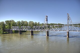
The Union Street Railroad Bridge is a vertical lift, Pratt through truss bridge that spans the Willamette River in Salem, Oregon, United States, built in 1912–13. It was last used by trains in the early 1990s and was sold for one dollar in 2003 to the City of Salem, which converted it to bicycle and pedestrian use in 2008–2009. It was added to the National Register of Historic Places in 2006.

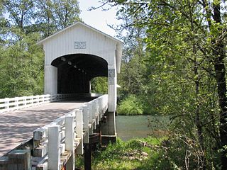
The Belknap Bridge crosses the McKenzie River near the unincorporated community of Rainbow in Lane County, Oregon, United States. It is approximately three miles west of the town of McKenzie Bridge which is named after the bridge. It is the fourth covered bridge built on the site. The bridge is well maintained and open to traffic. The Belknap Bridge is listed on the National Register of Historic Places.

The Goodpasture Bridge spans the McKenzie River near the community of Vida in Lane County, Oregon, United States. It is the second longest covered bridge and one of the most photographed covered bridges in the state. The Goodpasture Bridge is listed on the National Register of Historic Places.

The Willamette River is a 187-mile (301 km) tributary of the Columbia River in the U.S. state of Oregon. The upper tributaries of the Willamette originate in mountains south and southeast of the twin cities of Eugene and Springfield. Formed by the confluence of the Middle Fork Willamette River and Coast Fork Willamette River near Springfield, the main stem meanders generally north from source to mouth. The river's two most significant course deviations occur at Newberg, where the stream turns sharply east, and about 18 miles (29 km) downriver from Newberg, where it turns north again. Near its mouth, the river splits into two channels that flow around Sauvie Island. The main channel enters the Columbia about 101 miles (163 km) from the larger stream's mouth on the Pacific Ocean, and the smaller Multnomah Channel enters the Columbia about 14.5 miles (23.3 km) further downstream near St. Helens in Columbia County.
The Pengra Bridge is a covered bridge near Jasper in the U.S. state of Oregon. The 120-foot (37 m) Howe truss structure carries Place Road over Fall Creek in Lane County. It replaced an earlier bridge, built in 1904, that crossed the creek a few feet further upstream.

The Devil's Gate-Weber Hydroelectric Power Plant was built in 1909–1910 on the Weber River in northeastern Utah, United States, about 10 miles (16 km) southeast of Ogden. It was built by the Utah Light and Railway Company under the direction of E.H. Harriman, a director of the Union Pacific Railroad. It was one of the first powerplants in Utah designed to feed an electrical grid rather than as a source of power of a single locality.

The Horse Creek Bridge was a covered bridge near the unincorporated community of McKenzie Bridge in Lane County in the U.S. state of Oregon. Built in 1930, the structure, 105 feet (32 m) long, carried Horse Creek Road over Horse Creek. The creek is a tributary of the McKenzie River.

The Hayden RR Bridge, is a truss bridge located in Springfield, Oregon, spanning over the McKenzie River. It initially served as a traditional railroad bridge, starting as part of the first transcontinental railroad in Utah, before moving to its current location as part of the Marcola line, whose primary use was the distribution of lumber. It later closed alongside the area's lumber mills, and became a pedestrian bridge in 2019. It is one of the few remaining wrought-iron, Phoenixville bridges still standing, and the oldest intact bridge in the state of Oregon.


