Organ Mountains (New Mexico)

Last updated
Organ Mountains

Organ Mountains.jpg

The Organ Mountains seen from the west
Dimensions
Length 85 mi (137 km)N-S
Width 42 mi (68 km)W-E
Geography
USA New Mexico location map.svg
Red triangle with thick white border.svg
Location of the Organ Mountains within New Mexico
Country United States
State New Mexico
Region (northwest)- Chihuahuan Desert
District Doña Ana County, NM
Range coordinates 32°19.6′N106°33.35′W / 32.3267°N 106.55583°W / 32.3267; -106.55583 Coordinates: 32°19.6′N106°33.35′W / 32.3267°N 106.55583°W / 32.3267; -106.55583
Borders on San Andres Mountains
Geology
Type of rock granite, rhyolite

The Organ Mountains are a rugged mountain range in southern New Mexico in the Southwestern United States. Organ Mountains-Desert Peaks National Monument was declared a national monument on May 21, 2014. [1] They lie 10 miles (16 km) east of the city of Las Cruces, in Doña Ana County. [2]

New Mexico State of the United States of America

New Mexico is a state in the Southwestern region of the United States of America; its capital and cultural center is Santa Fe, which was founded in 1610 as capital of Nuevo México, while its largest city is Albuquerque with its accompanying metropolitan area. It is one of the Mountain States and shares the Four Corners region with Utah, Colorado, and Arizona; its other neighboring states are Oklahoma to the northeast, Texas to the east-southeast, and the Mexican states of Chihuahua to the south and Sonora to the southwest. With a population around two million, New Mexico is the 36th state by population. With a total area of 121,592 sq mi (314,920 km2), it is the fifth-largest and sixth-least densely populated of the 50 states. Due to their geographic locations, northern and eastern New Mexico exhibit a colder, alpine climate, while western and southern New Mexico exhibit a warmer, arid climate.

Southwestern United States Geographical region of the USA

The Southwestern United States, also known as the American Southwest, is the informal name for a region of the western United States. Definitions of the region's boundaries vary a great deal and have never been standardized, though many boundaries have been proposed. For example, one definition includes the stretch from the Mojave Desert in California to Carlsbad, New Mexico, and from the Mexico–United States border to the southern areas of Colorado, Utah, and Nevada. The largest metropolitan areas are centered around Phoenix, Las Vegas, Tucson, Albuquerque, and El Paso. Those five metropolitan areas have an estimated total population of more than 9.6 million as of 2017, with nearly 60 percent of them living in the two Arizona cities—Phoenix and Tucson.

Organ Mountains-Desert Peaks National Monument

The Organ Mountains-Desert Peaks National Monument is a United States National Monument in the state of New Mexico, managed by the Bureau of Land Management as part of the National Landscape Conservation System.

Contents

Geography

The Organ Mountains are near the southern end of a long line of mountains on the east side of the Rio Grande's rift valley. The range is nearly contiguous with the San Andres Mountains to the north and the Franklin Mountains to the south, but is very different geologically. Whereas the San Andres and Franklin Mountains are both formed from west-dipping fault blocks of mostly sedimentary strata (with limestone most prominent), the Organ Mountains are made primarily of igneous rock (intrusive granite and extrusive rhyolite). Their name reflects their similarity in appearance (particularly the granite "needles" in the highest part of the range) with pipes that would be part of a pipe organ.

Rio Grande River forming part of the US-Mexico border

The Rio Grande is one of the principal rivers in the southwest United States and northern Mexico. The Rio Grande begins in south-central Colorado in the United States and flows to the Gulf of Mexico. Along the way, it forms part of the Mexico–United States border. According to the International Boundary and Water Commission, its total length was 1,896 miles (3,051 km) in the late 1980s, though course shifts occasionally result in length changes. Depending on how it is measured, the Rio Grande is either the fourth- or fifth-longest river system in North America.

Rio Grande rift

The Rio Grande rift is a north-trending continental rift zone. It separates the Colorado Plateau in the west from the interior of the North American craton on the east. The rift extends from central Colorado in the north to the state of Chihuahua, Mexico, in the south. The rift zone consists of four basins that have an average width of 50 kilometers. The rift can be observed on location at Rio Grande National Forest, White Sands National Monument, Santa Fe National Forest, and Cibola National Forest, among other locations.

San Andres Mountains mountain in United States of America

The San Andres Mountains are a mountain range in the southwestern U.S. state of New Mexico, in the counties of Socorro, Sierra, and Doña Ana. The range extends about 75 miles (120 km) north to south, but are only about 12 miles (19 km) wide at their widest. The highest peak in the San Andres Mountains is Salinas Peak, at 8,965 feet.

The San Andres Mountains-(southern subrange of San Augustin Mountains), are separated from the Organ Mountains by San Augustin Pass, through which U.S. Highway 70 passes on its way to White Sands Missile Range, White Sands National Monument and Alamogordo. The Franklin Mountains are separated from the Organ Mountains by a 10-mile wide low area known as Anthony Gap. Much of this intervening land is part of Fort Bliss.

San Augustin Mountains

The San Augustin Mountains are a small mountain subrange at the southern terminus of the San Andres Mountains east of Las Cruces, New Mexico. Organ lies at the southwest foothills; the townsite, White Sands, NM lies to the southeast at the southwest of the Tularosa Valley.

U.S. Route 70 (US 70) is a part of the U.S. Highway System that travels from Globe, Arizona, east to Atlantic, North Carolina. In the U.S. state of New Mexico, US 70 extends from the Arizona state line south of Virden and ends at the Texas state line in Texico.

White Sands Missile Range military testing area in New Mexico, United States

White Sands Missile Range (WSMR) is a United States Army military testing area of almost 3,200 sq mi (8,300 km2) in parts of five counties in southern New Mexico. The largest military installation in the United States, WSMR and the 600,000-acre (2,400 km2) McGregor Range Complex at Fort Bliss to the south are contiguous areas for military testing. On 9 July 1945, the White Sands Proving Ground was established for testing German and American long range rockets. Just seven days later, the first atomic bomb test, code named Trinity was exploded at Trinity Site, near the north boundary of the range.

Geology

Orthoclase specimen from the Organ Mountains Orthoclase-120489.jpg
Orthoclase specimen from the Organ Mountains

The Organ Mountains are made up of three major sections:

Granite A common type of intrusive, felsic, igneous rock with granular structure

Granite is a common type of felsic intrusive igneous rock that is granular and phaneritic in texture. Granites can be predominantly white, pink, or gray in color, depending on their mineralogy. The word "granite" comes from the Latin granum, a grain, in reference to the coarse-grained structure of such a holocrystalline rock. Strictly speaking, granite is an igneous rock with between 20% and 60% quartz by volume, and at least 35% of the total feldspar consisting of alkali feldspar, although commonly the term "granite" is used to refer to a wider range of coarse-grained igneous rocks containing quartz and feldspar.

Quartz monzonite

Quartz monzonite or adamellite is an intrusive, felsic, igneous rock that has an approximately equal proportion of orthoclase and plagioclase feldspars. It is typically a light colored phaneritic (coarse-grained) to porphyritic granitic rock. The plagioclase is typically intermediate to sodic in composition, andesine to oligoclase. Quartz is present in significant amounts. Biotite and/or hornblende constitute the dark minerals. Because of its coloring, it is often confused with granite, but whereas granite contains more than 20% quartz, quartz monzonite is only 5–20% quartz. Rock with less than five percent quartz is classified as monzonite. A rock with more alkali feldspar is a syenite whereas one with more plagioclase is a quartz diorite. The fine grained volcanic rock equivalent of quartz monzonite is quartz latite.

Organ Needle mountain in United States of America

Organ Needle is the highest point of the Organ Mountains in the south-central part of the U.S. state of New Mexico. It lies in Doña Ana County, 13 miles (20,921 m) east-northeast of Las Cruces and 4 miles (6 km) southwest of White Sands, headquarters of the White Sands Missile Range. It is at the southeast end of a narrow ridge of vertically jointed granite called The Needles.

View of Organ Needle, the highest of the Organ Mountains at 8,990 feet (2,740 m). Organ Needle.jpg
View of Organ Needle, the highest of the Organ Mountains at 8,990 feet (2,740 m).

Botany

The Organ Mountains may be the most botanically diverse mountain range in New Mexico, with approximately 870 vascular plant species. Several of these, including the Organ Mountains evening-primrose (Oenothera organensis) and smooth figwort (Scrophularia laevis), are endemic to the mountain range and occur only in small, scattered populations.

The Organ Mountains also have surprisingly high diversity in ferns, with 30 of the 56 species reported for New Mexico occurring within it. The high diversity and endemism of the range makes the Organ Mountains a very rewarding destination for the botanically-inclined, as well as a focus of botanical study.

Fern group of plants

A fern is a member of a group of vascular plants that reproduce via spores and have neither seeds nor flowers. They differ from mosses by being vascular, i.e., having specialized tissues that conduct water and nutrients and in having life cycles in which the sporophyte is the dominant phase. Ferns have complex leaves called megaphylls, that are more complex than the microphylls of clubmosses. Most ferns are leptosporangiate ferns, sometimes referred to as true ferns. They produce coiled fiddleheads that uncoil and expand into fronds. The group includes about 10,560 known extant species.

Endemism Ecological state of being unique to a defined geographic location or habitat

Endemism is the ecological state of a species being unique to a defined geographic location, such as an island, nation, country or other defined zone, or habitat type; organisms that are indigenous to a place are not endemic to it if they are also found elsewhere. The extreme opposite of endemism is cosmopolitan distribution. An alternative term for a species that is endemic is precinctive, which applies to species that are restricted to a defined geographical area.

The flora differs greatly between the three sections of the mountain range, with the two igneous sections (The Needles and the central extrusive portion) sharing relatively few species with the southern limestone portions. The limestone section includes some of the northernmost populations of lechuguilla (Agave lecheguilla), often considered an indicator species of the Chihuahuan Desert, whereas the igneous sections of the range include all of the endemic taxa and have botanical affinity with Madrean flora typical of the southwestern sky islands.

Hiking and climbing

Winter snowfall in the Organ Mountains Organ Mountains WSA (9469542743).jpg
Winter snowfall in the Organ Mountains

The first documented climbs of Organ Mountain peaks were in the early 1890s, but most were done in the mid-1950s by climbers stationed at nearby Fort Bliss Army Base. The most prominent of these was R.L Ingraham, whose Guide to Climbing in the Organ Mountains [4] remains a definitive reference. To quote from this work:

"There are fragmentary records and local hearsay which affirm that certain students of the (then) A and M College climbed the Organ Needle and the Rabbit Ears Plateau, two of the very few Organ peaks with walk-up routes, between 1900 and 1910; little San Agustin was probably climbed at or before this time, too. Technical climbing began only in the late 1940's, with some ascents by a group of German rocket scientists brought here to work at the White Sands Proving Grounds directly after the fall of Germany. In 1955 a group of local mountaineering enthusiasts banded together into a climbing club, which was briefly called the "Tularosa Climbing Club" before it took its present name of "The Southwestern Mountaineers". From then on technical climbing went on apace, until today there are at least several routes up every peak."

The Bureau of Land Management maintains hiking trails accessed from four sites in the Organ Mountains:

The southern limestone section is difficult to access and rarely visited. Bishop's Cap can be reached through rugged dirt roads, but has no developed trails. Rattlesnake Ridge is entirely within Fort Bliss and closed to the general public.

National monument status

President Obama designated the Organ Mountains-Desert Peaks a national monument by executive authority on Wednesday, May 21, 2014. White House press secretary Jay Carney stated that "By establishing the monument, the president will permanently protect more than 496,000 acres to preserve the prehistoric, historic and scientific values of the area for the benefit of all Americans." [8]

See also

Related Research Articles

San Gabriel Mountains mountain range in Los Angeles and San Bernardino Counties, California

The San Gabriel Mountains are a mountain range located in northern Los Angeles County and western San Bernardino County, California, United States. The mountain range is part of the Transverse Ranges and lies between the Los Angeles Basin and the Mojave Desert, with Interstate 5 to the west and Interstate 15 to the east. This range lies in, and is surrounded by, the Angeles National Forest, with the San Andreas Fault as the northern border of the range.

Guadalupe Mountains National Park national park in Texas, USA

Guadalupe Mountains National Park is an American national park in the Guadalupe Mountains, east of El Paso, Texas. The mountain range includes Guadalupe Peak, the highest point in Texas at 8,749 feet (2,667 m), and El Capitan used as a landmark by travelers on the route later followed by the Butterfield Overland Mail stagecoach line. The ruins of a stagecoach station stand near the Pine Springs visitor center. The restored Frijole Ranch contains a small museum of local history and is the trailhead for Smith Spring. The park covers 86,367 acres in the same mountain range as Carlsbad Caverns National Park, about 25 miles (40 km) to the north in New Mexico. The Guadalupe Peak Trail winds through pinyon pine and Douglas-fir forests as it ascends over 3,000 feet (910 m) to the summit of Guadalupe Peak, with views of El Capitan and the Chihuahuan Desert.

Colorado Plateau plateau in the southwestern United States

The Colorado Plateau, also known as the Colorado Plateau Province, is a physiographic and desert region of the Intermontane Plateaus, roughly centered on the Four Corners region of the southwestern United States. This province covers an area of 336, 700 km2 (130,000 mi2) within western Colorado, northwestern New Mexico, southern and eastern Utah, and northern Arizona. About 90% of the area is drained by the Colorado River and its main tributaries: the Green, San Juan, and Little Colorado. Most of the remainder of the plateau is drained by the Rio Grande and its tributaries.

Santa Rosa Mountains (California)

The Santa Rosa Mountains are a short mountain range in the Peninsular Ranges system, located east of the Los Angeles Basin and northeast of the San Diego metropolitan area of southern California, in the southwestern United States.

Sacramento Mountains (New Mexico) mountain range

The Sacramento Mountains are a mountain range in the south-central part of the U.S. state of New Mexico, lying just east of Alamogordo in Otero County. From north to south, the Sacramento Mountains extend for 85 miles (137 km), and from east to west they encompass 42 miles (68 km).

Clipper Mountains

The Clipper Mountains are located in the Eastern Mojave Desert and protected within Mojave Trails National Monument, in San Bernardino County, California.

Franklin Mountains State Park Texas state park in El Paso, Texas

Franklin Mountains State Park is a Texas state park in El Paso, Texas, in the United States. Park headquarters are located at an elevation of 5,426 feet (1,654 m) with the highest peak reaching 7,192 feet (2,192 m). It is the largest urban park in the nation lying completely within city limits, covering 24,247.56 acres (9,813 ha). Franklin Mountains State Park is open year-round for recreational hiking, mountain biking, picnicking and scenic driving and vistas.

Franklin Mountains (Texas) Small range of mountains located in El Paso, Texas.

The Franklin Mountains of Texas are a small range that extend from El Paso, Texas north into New Mexico. The Franklins were formed due to crustal extension related to the Cenozoic Rio Grande rift. Although the present topography of the range and adjoining basins is controlled by extension during rifting in the last 10 million years, faults within the range also record deformation during the Laramide orogeny, between 85 and 45 million years ago.

Santa Rosa and San Jacinto Mountains National Monument protected area in California

The Santa Rosa and San Jacinto Mountains National Monument is a National Monument in southern California. It includes portions of the Santa Rosa and San Jacinto mountain ranges, the northernmost ones of the Peninsular Ranges system. The national monument covers portions of Riverside County, west of the Coachella Valley, approximately 100 miles (160 km) southeast of downtown Los Angeles.

Lincoln National Forest national forest in the US state of New Mexico

Lincoln National Forest is a unit of the U.S. Forest Service located in southern New Mexico. Established by Presidential Proclamation in 1902 as the Lincoln Forest Preserve, the 1,103,897 acres (4,467.31 km2) forest begins near the Texas border and contains lands in parts of Chaves, Eddy, Lincoln, and Otero, counties. The three Ranger Districts within the forest contain all or part of four mountain ranges, and include a variety of different environmental areas, from desert to heavily forested mountains and sub-alpine grasslands. Established to balance conservation, resource management, and recreation, the lands of the Lincoln National Forest include important local timber resources, protected wilderness areas, and popular recreation and winter sports areas. The forest headquarters is located in Alamogordo, N.M. with local offices in Carlsbad, Cloudcroft, and Ruidoso.

Angeles Forest Highway highway in California

The Angeles Forest Highway is a road over the San Gabriel Mountains in Los Angeles County, California. It connects the Los Angeles Basin with the Antelope Valley and western Mojave Desert. The highway is also known as County Road N-3 or FH-59 or the Palmdale cutoff; the route numbers are unsigned, but noted on many maps. It is about 25 miles (40 km) long.

Big Hatchet Mountains

The Big Hatchet Mountains are an 18 mi (29 km) long, mountain range in southeast Hidalgo County, New Mexico, adjacent the northern border of Chihuahua state, Mexico.

Jackson Mountains

The Jackson Mountains are a north-northeast trending mountain range in southwestern Humboldt County, Nevada. The range is flanked on the west by the Black Rock Desert and the Black Rock Range beyond. To the north across the Quinn River and Nevada State Route 140 lie the Bilk Creek Mountains. To the northeast across Kings River Valley is the Double Mountains and to the east are the Sleeping Hills. To the southeast and south lie the Eugene and Kamma Mountains. The ghost town of Sulphur lies just southwest of the pass between the Jackson and Kamma ranges. Nevada State Route 49 and the Union Pacific railroad Feather River Route traverse this pass.

Geography of Arizona

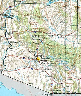
Arizona is a landlocked state situated in the southwestern region of the United States of America. It has a vast and diverse geography famous for its deep canyons, high- and low-elevation deserts, numerous natural rock formations, and volcanic mountain ranges. Arizona shares land borders with Utah to the north, the Mexican state of Sonora to the south, New Mexico to the east, and Nevada to the northwest, as well as water borders with California and the Mexican state of Baja California to the southwest along the Colorado River. Arizona is also one of the Four Corners states and is diagonally adjacent to Colorado.

Huachuca Mountains

The Huachuca Mountain range is part of the Sierra Vista Ranger District of the Coronado National Forest. The Huachuca Mountains are located in Cochise County, Arizona approximately 70 miles (110 km) south-southeast of Tucson and southwest of the city of Sierra Vista, Arizona. Included in this area is the highest peak in the Huachucas, Miller Peak, and the region of the Huachucas known as Canelo Hills in eastern Santa Cruz County. The mountains range in elevation from 3,934 feet (1,199 m) at the base to 9,466 feet (2,885 m) at the top of Miller Peak. The second highest peak in this range is Carr Peak, elevation 9,200 feet (2,804 m). The Huachuca Mountain area is owned principally by the USDA Forest Service (41%), the U.S. Army (20%), and private land (32%). Sierra Vista is the main population center.

Santa Rosa Wilderness

The Santa Rosa Wilderness is a 72,259-acre (292.42 km2) wilderness area in Southern California, in the Santa Rosa Mountains of Riverside and San Diego counties, California. It is in the Colorado Desert section of the Sonoran Desert, above the Coachella Valley and Lower Colorado River Valley regions in a Peninsular Range, between La Quinta to the north and Anza Borrego Desert State Park to the south. The United States Congress established the wilderness in 1984 with the passage of the California Wilderness Act, managed by the both US Forest Service and the Bureau of Land Management. In 2009, the Omnibus Public Land Management Act was signed into law which added more than 2,000 acres (8.1 km2). Most of the Santa Rosa Wilderness is within the Santa Rosa and San Jacinto Mountains National Monument.

Clipper Mountain Wilderness

The Clipper Mountain Wilderness is a wilderness area in the Clipper Mountains of the eastern Mojave Desert and within Mojave Trails National Monument, located in northeastern San Bernardino County, California. It is under the jurisdiction of the Bureau of Land Management.

Cookes Range

The Cookes Range is a small, 17-mi (27 km) long mountain range in northern Luna County, New Mexico, which extends slightly north into southeastern Grant County. The range is a southern continuation of the Mimbres Mountains, itself the southeast portion of the extensive north-south running Black Range. The Cooks Range is surrounded by lower elevation areas of the northwest Chihuahuan Desert.

References