

Guam The following outline is provided as an overview of and topical guide to Guam:
Contents
- General reference
- Geography of Guam
- Environment of Guam
- Regions of Guam
- Demography of Guam
- Government and politics of Guam
- Branches of the government of Guam
- Foreign relations of Guam
- Law and order in Guam
- Local government in Guam
- History of Guam
- History of Guam, by period
- Culture of Guam
- Art in Guam
- Sports in Guam
- Economy and infrastructure of Guam
- Infrastructure of Guam
- Education in Guam
- See also
- References
- External links
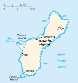
Guam – organized, unincorporated territory of the United States of America that comprises the island of Guam in the western North Pacific Ocean. [1] It is one of five U.S. territories with an established civilian government. [2] The island's capital is Hagåtña (formerly Agana). Guam is the largest and southernmost of the Mariana Islands. The Chamorros, Guam's indigenous inhabitants, first populated the island approximately 4,000 years ago.[ citation needed ] Discovered by the Spanish expedition of Ferdinand Magellan in 1521, the island has a long history of European colonialism beginning in the 16th century, and especially in 1668 with the arrival of Spanish settlers including Padre San Vitores, a Catholic missionary. Guam and the rest of the Mariana Islands were integrated in the Spanish East Indies since 1565. The island was a major stopover for Manila Galleons sailing from Acapulco, until 1815. Guam was taken over from Spain by the United States during the Spanish–American War in 1898. As the largest island in Micronesia and the only American-held island in the region before World War II, Guam was occupied by the Japanese between December 1941 and July 1944. Today, Guam's economy is mainly supported by tourism (primarily from Japan) and U.S. military bases. [3]