Pa Dali | |
|---|---|
 Pa Dali | |
| Coordinates: 3°33′N115°33′E / 3.55°N 115.55°E Coordinates: 3°33′N115°33′E / 3.55°N 115.55°E | |
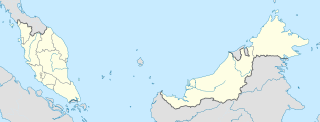
| Country | |
| State | |
| Administrative Division | Marudi |
| Elevation | 1,158 m (3,799 ft) |
Pa Dali (also called Pa Dalih [1] ) is a Kelabit settlement in the Marudi division of Sarawak, Malaysia. [2] [3] It lies approximately 619.9 kilometres (385 mi) east-north-east of the state capital Kuching, in the Kelabit Highlands.

The Kelabit are an indigenous Dayak people of the Sarawak/North Kalimantan highlands of Borneo with a minority in the neighbouring state of Brunei. They have close ties to the Lun Bawang. The elevation there is slightly over 1,200 meters. In the past, because there were few roads and because the area was largely inaccessible by river because of rapids, the highlands and the Kelabit were relatively untouched by modern western influences. Now, however, there is a relatively permanent road route on which it is possible to reach Bario by car from Miri. The road is marked but driving without a local guide is not advisable, as it takes over 11 hours of driving to reach Bario from Miri through many logging trail junctions and river crossings.
Marudi is a town on the Baram River in Miri Division, Sarawak, Malaysia. Marudi is a quiet town situated inland from Miri, similar in size to Kapit though nowhere near as busy. Its main attraction is another of the Brooke outposts, the beige wooden Fort Hose. It is the cultural heart of Sarawak's highland tribesfolk, collectively called Orang Ulu. Before Miri was founded, Marudi was the administrative centre of the northern region of Sarawak.
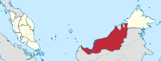
Sarawak is a state of Malaysia. The largest among the 13 states, with an area almost equal to that of Peninsular Malaysia, Sarawak is located in northwest Borneo Island, and is bordered by the Malaysian state of Sabah to the northeast, Kalimantan to the south, and Brunei in the north. The capital city, Kuching, is the largest city in Sarawak, the economic centre of the state, and the seat of the Sarawak state government. Other cities and towns in Sarawak include Miri, Sibu, and Bintulu. As of the 2015 census, the population of Sarawak was 2,636,000. Sarawak has an equatorial climate with tropical rainforests and abundant animal and plant species. It has several prominent cave systems at Gunung Mulu National Park. Rajang River is the longest river in Malaysia; Bakun Dam, one of the largest dams in Southeast Asia, is located on one of its tributaries, the Balui River. Mount Murud is the highest point in Sarawak.
It lies on the so-called Bario loop, the most popular 3-day trek in the Bario area, which passes through the Kelabit villages of Pa Dalih, Pa Ramadu and Pa Mada, [1] and is described as a friendly and hospitable village.

Bario is a community of 13 to 16 villages located on the Kelabit Highlands in Miri Division, Sarawak, Malaysia, lying at an altitude of 1000 m (3280 ft) above sea level. It is located close to the Sarawak-Kalimantan border, 178 km to the east of Miri. It is the main settlement for the indigenous Kelabit tribe. There are regular flights between the Bario, Miri and Marudi.
It was reported in 1974 that an ancient burial ground with stone urns, slab graves and porcelain urns was found at about 3300 feet near Pa Dali. [4] At the time, the village was uninhabited following its evacuation during the Indonesia–Malaysia confrontation of 1962–1966.

The Indonesian–Malaysian confrontation or Borneo confrontation was a violent conflict from 1963–66 that stemmed from Indonesia's opposition to the creation of Malaysia. The creation of Malaysia was the amalgamation of the Federation of Malaya, Singapore and the crown colony/British protectorates of North Borneo and Sarawak in September 1963. Important precursors to the conflict included Indonesia's policy of confrontation against Netherlands New Guinea from March–August 1962 and the Brunei Revolt in December 1962.
Neighbouring settlements include:
- Batu Paton 1.9 kilometres (1.2 mi) south
- Pa Bangar 5.6 kilometres (3.5 mi) north
- Long Danau 5.9 kilometres (3.7 mi) west
- Pa Mada 5.9 kilometres (3.7 mi) north
- Ramudu Hulu 7.4 kilometres (4.6 mi) west
- Pa Main 10 kilometres (6.2 mi) north
- Pa Umor 20.7 kilometres (12.9 mi) north
- Bario 24.9 kilometres (15.5 mi) northwest
- Lepu Wei 25.9 kilometres (16.1 mi) south
- Pa Lungan 27.9 kilometres (17.3 mi) north

Batu Paton is a settlement in Sarawak, Malaysia. It lies approximately 619.2 kilometres (385 mi) east-north-east of the state capital Kuching.
Pa Bangar is a settlement in the Marudi division of Sarawak, Malaysia. It lies approximately 621.9 kilometres (386 mi) east-north-east of the state capital Kuching.
Long Danau is a longhouse settlement in the Marudi division of Sarawak, Malaysia. It lies approximately 615.3 kilometres (382 mi) east-north-east of the state capital Kuching.
