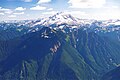
Sloan Peak is a 7,835-foot (2,388-metre) mountain in the North Cascades of Washington state. It rises about 40 miles (64 km) east of Everett, Washington and 12 miles southwest of Glacier Peak, one of the Cascade stratovolcanoes. It is located between the north and south forks of Sauk River, in the Mount Baker–Snoqualmie National Forest. The summit is situated about 4 miles (6.4 km) east of the Mountain Loop Highway.

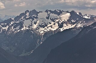
Sahale Mountain is a jagged, glaciated mountain, in North Cascades National Park, in northern Washington state. The summit of Sahale Mountain is referred to as Sahale Peak. It is 0.3 miles (0.48 km) south of its higher neighbor, Boston Peak, and the saddle between the two is 80 feet (24 m) lower than Sahale's summit. Quien Sabe Glacier is to the west of the ridge between the two peaks while Davenport Glacier is in a cirque east of this ridge and above Horseshoe Basin. Sahale Glacier is south of the summit and east of Sahale Arm, a ridge that extends southwest from Sahale to Cascade Pass. The name Sahale may originate from a Northwest Native American word meaning "high place," "falcon," or "sacred."

Kimtah Peak, elevation 8,600+ feet, is in North Cascades National Park in the U.S. state of Washington. Kimtah Peak is a summit along a ridge known as Ragged Ridge. Kimtah Glacier is on the northwest slopes of the peak, while Katsuk Glacier is to the northeast.

Tomyhoi Peak is a 7,439-foot (2,267-metre) Skagit Range mountain situated one mile south of the Canada–United States border, in the North Cascades of Washington state. It is located west of Mount Larrabee and within the Mount Baker Wilderness, which is part of the Mount Baker-Snoqualmie National Forest. This mountain's toponym was officially adopted in 1913 by the U.S. Board on Geographic Names.

Frisco Mountain is a 7,760-foot (2,365-metre) mountain summit in the Cascade Range in the U.S. state of Washington. It is located two miles southwest of Rainy Pass on the borders of the Stephen Mather Wilderness and North Cascades National Park. First climbed by surveyor Lage Wernstedt in 1926, the mountain derives its name from a mining claim on the south side that was worked in the 1920s. Its nearest higher peak is Rainy Peak, 0.54 mi (0.87 km) to the east-southeast. Precipitation runoff from Frisco Mountain drains into Rainy Lake and tributaries of Bridge Creek. The retreating Lyall Glacier in its northeast cirque contributes to waterfalls which tumble 1,000 ft (300 m) into Rainy Lake.

Ruth Mountain is a 7,115 ft (2,170 m) Skagit Range summit located two miles south of Hannegan Pass in the North Cascades of Washington state. The name honors Ruth Cleveland, daughter of President Grover Cleveland. This mountain's name was officially adopted in 1952 by the United States Board on Geographic Names. Ruth Mountain is situated on the shared border of North Cascades National Park and the Mount Baker Wilderness, which is part of the Mount Baker-Snoqualmie National Forest. The summit offers views of Mount Shuksan, East Nooksack Glacier, Seahpo Peak, Nooksack Tower, Icy Peak, Mount Sefrit, Mineral Mountain, and the Picket Range. The melting and receding Ruth Glacier on the north slope of Ruth creates the headwaters for the Chilliwack River. Precipitation runoff also finds its way into the Nooksack and Baker Rivers.

Azurite Peak is an 8,434-foot (2,571-metre) double-summit mountain located at the common boundary point of Okanogan County, Skagit County, and Whatcom County in Washington state. It is part of the Okanogan Range which is a sub-range of the North Cascades Range. Azurite Peak ranks as the 81st-highest summit in the state. Azurite Peak is situated north of Azurite Pass on land administered by the Okanogan–Wenatchee National Forest. The nearest higher neighbor is Tower Mountain, 5.24 miles (8.43 km) to the south-southeast, and Mount Ballard lies 1.97 miles (3.17 km) to the north. Remnants of a small pocket glacier are found on the east aspect. Precipitation runoff from the peak drains north into tributaries of the Skagit River, and south into the Methow River. Topographic relief is significant as the summit rises over 3,000 feet above Mill Creek in one mile (1.6 km). The Pacific Crest Trail traverses the base of Azurite Peak.

Mount Misch is a remote 7,435 ft mountain summit in the North Cascades, in Skagit County of Washington state. It is the highest point of the Buckindy Range, or Buckindy Ridge. It is located 19 miles east-northeast of Darrington, Washington, and 15 miles north-northwest of Glacier Peak which is one of the Cascade stratovolcanoes. It is situated in the Glacier Peak Wilderness on land administered by the Mount Baker-Snoqualmie National Forest. Mount Misch was named by mountaineer and author Fred Beckey for his friend Peter Misch (1909-1987), University of Washington geology professor and mountaineer, who was renowned for his study of the North Cascades. Precipitation runoff from Mount Misch and the unnamed Goat Creek glacier on its east slope drains into tributaries of the Suiattle River and ultimately the Skagit River.

White Mountain is a 7,043-foot (2,147-metre) mountain located in the Glacier Peak Wilderness of the North Cascades in Washington state. The mountain is situated on the crest of the Cascade Range, on the shared border of Snohomish County and Chelan County, and also straddling the boundary between Mount Baker-Snoqualmie National Forest and Wenatchee National Forest. White Mountain is located 3.04 mi (4.89 km) to the west-southwest of Kololo Peaks, and immediately north of White Pass. The Pacific Crest Trail traverses the south slope of the peak. Precipitation runoff from the peak drains into the White River, White Chuck River, and Sauk River. The mountain's name was suggested by The Mountaineers, and officially adopted in 1918 by the United States Board on Geographic Names.

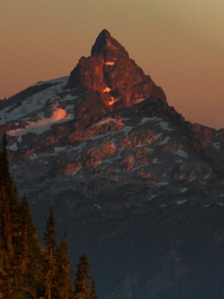
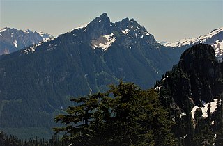
Tupshin Peak is an 8,347-foot (2,544-metre) mountain summit located in the Glacier Peak Wilderness of the North Cascades in Washington state. The mountain is situated in Chelan County, on land managed by Wenatchee National Forest. The nearest higher neighbor is Devore Peak, 1.55 mi (2.49 km) to the south-southwest, and Bonanza Peak lies 6.71 mi (10.80 km) to the southwest. Precipitation runoff from the peak drains to nearby Lake Chelan via tributaries of the Stehekin River. The mountain's name comes from Chinook jargon and means "needle".

Emerald Peak is an 8,422-foot-elevation (2,567-meter) mountain summit located in the Chelan Mountains, in Chelan County of Washington state.

Saska Peak is an 8,404 ft (2,560 m) mountain summit located in the Chelan Mountains, in Chelan County of Washington state. The mountain is situated in Glacier Peak Wilderness of the North Cascades, on land managed by Wenatchee National Forest. Saska Peak ranks as the third-highest peak in the Chelan Mountains, and 74th-highest summit in Washington state. Its nearest higher neighbor is Emerald Peak, 0.66 mi (1.06 km) to the east-northeast, and Cardinal Peak is positioned 1.52 mi (2.45 km) to the east-southeast. These three highest peaks of the Chelan Mountains enclose the head of North Fork Entiat River valley. Precipitation runoff from the peak drains into the Entiat River drainage basin. The mountain's name honors Shil-how-Saskt, Tribal chief of the Entiat people, and was applied by Albert Hale Sylvester (1871-1944), a pioneer surveyor, topographer, and forest supervisor who named thousands of geographic features in the Cascades. In the Columbia-Moses language (Salishan), this name means "Standing in the middle of the sky."

Mount Arriva is an 8,215 ft (2,500 m) elevation mountain summit located in the North Cascades in the U.S. state of Washington. It is situated in North Cascades National Park, on the shared border of Chelan County and Skagit County. Despite its position only 1.55 mi (2.49 km) southwest of Easy Pass, and 3.7 mi (6.0 km) west of the North Cascades Highway, it is not visible from either. Its nearest higher peak is Black Peak, 2.57 mi (4.14 km) to the southeast. Mount Arriva has a secondary summit, called East Peak, which was first climbed in August 1940 by Fred Beckey, Jim Crooks, and Ed Kennedy. The first ascent of the true summit was made July 6, 1966, by Joe and Joan Firey, John and Irene Meulemans.

Tenpeak Mountain is an 8,312-foot (2,533-metre) mountain summit located in the Glacier Peak Wilderness of the North Cascades in Washington state. Tenpeak is situated on the crest of the Cascade Range, on the shared border of Snohomish County and Chelan County, also straddling the boundary between the Mount Baker-Snoqualmie National Forest and the Wenatchee National Forest. Its nearest higher neighbor is Luahna Peak, 2.5 mi (4.0 km) to the southeast. Topographic relief is significant since the northern aspect of the mountain rises 4,200 feet above the Suiattle Valley in approximately 1.5 mi (2.4 km). This mountain has small, unnamed, hanging glaciers in cirques surrounding the summit, and the terminus of the Honeycomb Glacier lies below the western base of the mountain. Precipitation runoff from the mountain and meltwater from the glaciers drains south into White River; or north into the Suiattle River. This mountain's descriptive name was suggested by The Mountaineers, and was officially adopted in 1918 by the U.S. Board on Geographic Names. The first ascent was made September 21, 1940, by Lloyd Anderson and Tom Campbell.

Bandit Peak is a 7,625-foot (2,324-metre) double-summit granitic mountain located in the Glacier Peak Wilderness of the North Cascades, in Chelan County of Washington state. The mountain is situated east of the crest of the Cascade Range, on land managed by the Okanogan–Wenatchee National Forest. Its nearest higher neighbor is Brahma Peak, 5.9 mi (9.5 km) to the north. Bandit Peak is the ninth-highest peak on Chiwawa Ridge, and other notable peaks on this ridge include Mount Berge, Buck Mountain, Cirque Mountain, Napeequa Peak, Helmet Butte, and Chiwawa Mountain. Precipitation runoff from Bandit Peak drains west into Napeequa River; or east into the Chiwawa River.

Black Mountain is a 7,262-foot-elevation (2,213-meter) summit located in the North Cascades, in Snohomish County of Washington state. The mountain is situated in the Glacier Peak Wilderness on land managed by Mount Baker-Snoqualmie National Forest. Neighbors include line parent Kololo Peaks, 6 mi (9.7 km) to the east, Painted Mountain two miles west, and Glacier Peak is 5 mi (8.0 km) to the northeast. Precipitation runoff from the peak drains west into tributaries of the North Fork Sauk River, and east into the White Chuck River. Topographic relief is significant as the summit rises 3,460 feet above the White Chuck in two miles. The first ascent of the summit was likely made in 1897 by a survey team including A. H. Dubor, Thomas G. Gerdine, and Sam Strom, who named the mountain for the dark color of its rock. The ascent from the north via Lake Byrne is non-technical.
Bedal Peak is a 6,554-foot-elevation (1,998-meter) mountain summit located in the North Cascades, in Snohomish County of Washington state. The mountain is situated in the Henry M. Jackson Wilderness, on land managed by Mount Baker-Snoqualmie National Forest. The nearest higher neighbor is line parent Sloan Peak, 2 mi (3.2 km) to the south-southeast. Precipitation runoff from the peak drains west to the South Fork Sauk River via Bedal Creek, as well as north and east into tributaries of the North Fork. The north and south forks merge at the northwest base of the mountain to form the Sauk River. Topographic relief is significant as the summit rises 5,250 feet above the Sauk River Valley and Mountain Loop Highway in approximately two miles.
Mount Buckindy is a remote 7,320-foot-elevation (2,230-meter) mountain summit located in the North Cascades, in Skagit County of Washington state. It is the second-highest point of the Buckindy Range, or Buckindy Ridge. It is set in the Glacier Peak Wilderness on land managed by the Mount Baker-Snoqualmie National Forest. It is situated 20 miles east-northeast of Darrington, Washington, and 17 miles north-northwest of Glacier Peak which is one of the Cascade stratovolcanoes. Precipitation runoff from Mount Buckindy drains south to the Suiattle River via Buck Creek and Downey Creek, and north to the Cascade River via Kindy Creek. Topographic relief is significant as the summit rises 4,700 feet above Kindy Creek in less than two miles. The mountain's toponym is a portmanteau of Buck and Kindy Creeks, and has been officially adopted by the United States Board on Geographic Names.

Portal Peak is a 6,999-foot (2,133-metre) mountain summit in Snohomish County, Washington, United States.

Kodak Peak is a 6,132-foot-elevation (1,869-meter) summit on the border shared by Chelan and Snohomish counties in Washington, United States.