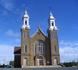
Paquetville

Last updated

Paquetville
Eglise Paquetville.JPG
Canada New Brunswick location map 2.svg
Red pog.svg
Paquetville
Location within New Brunswick.
Coordinates: 47°40′08″N65°05′57″W / 47.668889°N 65.099167°W / 47.668889; -65.099167
CountryCanada
Province New Brunswick
County Gloucester
Parish Paquetville
Town Hautes-Terres
Established1866
Village Status1966
Electoral Districts   
Federal

Acadie—Bathurst
Provincial Centre-Péninsule-Saint-Sauveur
Area
[1]
  Land9.26 km2 (3.58 sq mi)
Population
 (2021) [1]
  Total718
  Density77.5/km2 (201/sq mi)
  Change (2016–21)
Decrease2.svg 0.3%
  Dwellings
359
Time zone UTC-4 (AST)
  Summer (DST) UTC-3 (ADT)
Postal code(s)
E8R
Area code 506
Highways
NB 135.svg Route 135

NB 340.svg Route 340
NB 350.svg Route 350
Monseigneur Paquet, founder of Paquetville Portrait Joseph-Marie Paquet.jpg
Monseigneur Paquet, founder of Paquetville

Paquetville is a former village in Gloucester County, New Brunswick, Canada. [2] It held village status prior to 2023 and is now part of the town of Hautes-Terres. It is on the Acadian Peninsula at the intersection of Route 340, Route 135 and Route 350.

Contents

History

Paquetville was founded by Monseigneur Paquet in 1873, who brought several parishioners with him from Shippagan.

On 1 January 2023, Paquetville amalgamated with the village of Saint-Isidore and all or part of six local service districts to form the new town of Hautes-Terres. [3] [4] The community's name remains in official use. [5]

Demographics

Historical Census Data - Paquetville [6]
YearPop.±%
1991 688    
1996 731+6.2%
2001 667−8.8%
2006 642−3.7%
2011 706+10.0%
2016 720+2.0%
2021 718−0.3%
Source: [1]

In the 2021 Census of Population conducted by Statistics Canada, Paquetville had a population of 718 living in 324 of its 359 total private dwellings, a change of -0.3% from its 2016 population of 720. With a land area of 9.26 km2 (3.58 sq mi), it had a population density of 77.5/km2 (200.8/sq mi) in 2021. [1]

Canada census – Paquetville community profile
2021 2016 2011
Population718 (-0.3% from 2016)720 (+2.0% from 2011)706 (+10.0% from 2006)
Land area9.26 km2 (3.58 sq mi)9.26 km2 (3.58 sq mi)9.40 km2 (3.63 sq mi)
Population density77.5/km2 (201/sq mi)77.8/km2 (202/sq mi)75.1/km2 (195/sq mi)
Median age53.2 (M: 51.2, F: 54.8)48.9 (M: 45.8, F: 51.5)46.9 (M: 45.6, F: 48.3)
Private dwellings325 (total) 346 (total) 309 (total) 
Median household income$48,896$52,040
References: 2021 [7] 2016 [8] 2011 [9] earlier [10] [11]

Language

Canada Census Mother Tongue - Municipality, Quebec [6]
CensusTotal
French
English
French & English
Other
YearResponsesCountTrendPop %CountTrendPop %CountTrendPop %CountTrendPop %
2011
680
650Increase2.svg 13.0%95.59%15Increase2.svg 50.0%2.21%10Decrease2.svg 33.3%1.47%5Increase2.svg n/a%0.73%
2006
600
575Decrease2.svg 10.8%95.83%10Steady2.svg 0.0%1.67%15Increase2.svg n/a%2.50%0Steady2.svg 0.0%0.00%
2001
655
645Steady2.svg 0.0%98.47%10Decrease2.svg 50.0%1.53%0Steady2.svg 0.0%0.00%0Steady2.svg 0.0%0.00%
1996
665
645n/a96.99%20n/a3.01%0n/a0.00%0n/a0.00%

Notable people

The village is the home of Édith Butler, who sings the song Paquetville.

See also

Related Research Articles

<span class="mw-page-title-main">Gloucester County, New Brunswick</span> County in New Brunswick, Canada

Gloucester County is located in the northeastern corner of New Brunswick, Canada. Fishing, mining and forestry are the major industries in the county. The eastern section of the county is known for its Acadian culture. The county is named for Princess Mary, Duchess of Gloucester and Edinburgh.

<span class="mw-page-title-main">Shippagan</span> Town in New Brunswick, Canada

Shippagan is a Canadian town within Shippegan Parish, Gloucester County, New Brunswick.

<span class="mw-page-title-main">Petit-Rocher, New Brunswick</span> Community in New Brunswick, Canada

Petit-Rocher is a former village in Gloucester County, New Brunswick. It held village status prior to 2023 and is now part of the town of Belle-Baie. Sitting on the western shore of both Chaleur Bay and Nepisiguit Bay 20 km northwest of Bathurst.

<span class="mw-page-title-main">Petitcodiac, New Brunswick</span> Place in New Brunswick, Canada

Petitcodiac is a former village in Westmorland County, New Brunswick, Canada. It held village status prior to 2023 and is now part of the village of Three Rivers.

<span class="mw-page-title-main">Bertrand, New Brunswick</span> Place in New Brunswick, Canada

Bertrand is a former village in Gloucester County, New Brunswick, Canada. It held village status prior to 2023 and is now part of the town of Rivière-du-Nord.

<span class="mw-page-title-main">Lamèque</span> Place in New Brunswick, Canada

Lamèque is a former town in Gloucester County, New Brunswick, Canada. It held town status prior to 2023 and is now part of the town of Île-de-Lamèque.

<span class="mw-page-title-main">Grande-Anse, New Brunswick</span> Place in New Brunswick, Canada

Grande-Anse is a former village in Gloucester County, New Brunswick, Canada. It held village status prior to 2023 and is now part of the town of Rivière-du-Nord.

<span class="mw-page-title-main">Le Goulet, New Brunswick</span> Place in New Brunswick, Canada

Le Goulet is a former village in Gloucester County, New Brunswick, Canada. Located several kilometres east-southeast of downtown Shippagan, it sits on the Gulf of St. Lawrence. Formerly an incorporated village, it is now part of the town of Shippagan.

Neguac is a Canadian village in Northumberland County, New Brunswick.

Port Elgin is a former Canadian village in Westmorland County, New Brunswick. It is located near the Nova Scotia border at the mouth of the Gaspereaux River where it empties into the Northumberland Strait's Baie Verte and is now part of the rural community of Strait Shores.

<span class="mw-page-title-main">Saint-Isidore, New Brunswick</span> Place in New Brunswick, Canada

Saint-Isidore is a former village in Gloucester County, New Brunswick, Canada. It held village status prior to 2023 and is now part of the town of Hautes-Terres. It is adjacent to the communities of Pont-Landry, Hacheyville, Bois-Gagnon and Tilley Road. The community is situated on the Acadian Peninsula.

Saint-Léolin is a former village on the Acadian Peninsula in Gloucester County, New Brunswick, Canada. It held village status prior to 2023 and is now part of the town of Rivière-du-Nord.

Sainte-Marie-Saint-Raphaël is a former village in Gloucester County, New Brunswick, Canada. It held village status prior to 2023 and is now part of the town of Île-de-Lamèque.

<span class="mw-page-title-main">Inkerman Parish, New Brunswick</span> Parish in New Brunswick, Canada

Inkerman is a geographic parish in Gloucester County, New Brunswick, Canada.

<span class="mw-page-title-main">New Bandon Parish, New Brunswick</span> Parish in New Brunswick, Canada

New Bandon is a geographic parish in Gloucester County, New Brunswick, Canada.

<span class="mw-page-title-main">Paquetville Parish, New Brunswick</span> Parish in New Brunswick, Canada

Paquetville is a geographic parish in Gloucester County, New Brunswick, Canada.

<span class="mw-page-title-main">Caraquet Parish, New Brunswick</span> Parish in New Brunswick, Canada

Caraquet is a geographic parish in Gloucester County, New Brunswick, Canada.

<span class="mw-page-title-main">Saint-Isidore Parish, New Brunswick</span> Parish in New Brunswick, Canada

Saint-Isidore is a geographic parish in Gloucester County, New Brunswick, Canada.

<span class="mw-page-title-main">Allardville Parish, New Brunswick</span> Parish in New Brunswick, Canada

Allardville is a geographic parish in Gloucester County, New Brunswick, Canada,

<span class="mw-page-title-main">Caraquet</span> Town in New Brunswick, Canada

Caraquet is a town in Gloucester County, New Brunswick, Canada.

References

  1. 1 2 3 4 "Census Profile of Paquetville". Statistics Canada. 6 December 2022. Retrieved 21 January 2023.
  2. New Brunswick Provincial Archives - Paquetville
  3. "Local Governments Establishment Regulation – Local Governance Act". Government of New Brunswick. 12 October 2022. Retrieved 21 January 2023.
  4. "RSC 4 Acadian Peninsula Regional Service Commission". Government of New Brunswick. Retrieved 21 January 2023.
  5. "Proposed entity names reflect strong ties to nature and history" (Press release). Irishtown, New Brunswick: Government of New Brunswick. 25 May 2022. Retrieved 21 January 2023.
  6. 1 2 Statistics Canada: 1996, 2001, 2006, 2011 census
  7. "2021 Community Profiles". 2021 Canadian Census . Statistics Canada. February 4, 2022. Retrieved 2022-04-27.
  8. "2016 Community Profiles". 2016 Canadian Census . Statistics Canada. August 12, 2021. Retrieved 2019-03-28.
  9. "2011 Community Profiles". 2011 Canadian Census . Statistics Canada. March 21, 2019. Retrieved 2014-04-06.
  10. "2006 Community Profiles". 2006 Canadian Census . Statistics Canada. August 20, 2019.
  11. "2001 Community Profiles". 2001 Canadian Census . Statistics Canada. July 18, 2021.

47°40′08″N65°05′57″W / 47.66889°N 65.09917°W / 47.66889; -65.09917