Paquetville Parish, New Brunswick

Last updated

Paquetville
Gloucester County NB - Paquetville Parish.PNG
Location within Gloucester County, New Brunswick
Coordinates: 47°37′30″N65°12′54″W / 47.625°N 65.215°W / 47.625; -65.215
Country Flag of Canada (Pantone).svg  Canada
Province Flag of New Brunswick.svg  New Brunswick
County Gloucester
Erected1897
Area
[1]
  Land220.42 km2 (85.10 sq mi)
Population
 (2021) [1]
  Total2,250
  Density10.2/km2 (26/sq mi)
  Change 2016-2021
Decrease2.svg 3.4%
  Dwellings
1,145
Time zone UTC-4 (AST)
  Summer (DST) UTC-3 (ADT)
Figures do not include portions within the village of Paquetville and the regional municipality of Tracadie

Paquetville is a geographic parish in Gloucester County, New Brunswick, Canada. [4]

Contents

For governance purposes, is its divided between the towns of Hautes-Terres and Rivière-du-Nord, the regional municipality of Tracadie, [5] and the Chaleur rural district. [6] The municipalities are members of the Acadian Peninsula Regional Service Commission, while the rural district is a member of the Chaleur RSC. [7]

Origin of name

The parish may have been named in honour of Joseph-Marie Paquet, [8] a priest influential in New Brunswick church politics [9] and parish priest at Caraquet for two decades before his death in 1869.

History

Paquetville was erected in 1897 from Caraquet Parish. [10]

In 1903 the spelling was changed to Pacquetville [11] then changed back in 1941. [12]

Boundaries

Paquetville Parish is bounded: [2] [13] [14]

Former Governance

Prior to the 2023 governance reform, there were two villages – Bertrand and Paquetville – and three local service districts at least party within the parish, the LSDs of the Paroisse Notre-Dame-des-Érables, the parish of Paquetville, and the parish of Saint-Isidore. [15]

The three local service districts provided basic LSD services along with street lighting and community & recreation services. [16]

The Regional Municipality of Tracadie includes the southeastern corner of the parish along the Pokemouche River, an area about 2.1 kilometres long. Route 355 runs briefly along the parish line but otherwise there's no provincial highway access to the area.

The village of Bertrand occupied the northeastern corner of the parish, including the community of Haut-Bertrand; it is now part of Rivière-du-Nord. [5]

The village of Paquetville contained a nearly square area along Route 135 where it's met by Rue des Fondateurs and Route 340; it is now part of Hautes-Terres. [5]

The Paroisse Notre-Dame-des-Érables was an LSD in the northwestern corner of the parish, based on four tiers of grants along Route 340 and the Val-Doucet Road. The eastern boundary along the Route 340 tiers was about 1 kilometres west of Chemin du Portage, and along the Val-Doucet tiers about 700 metres east of the main part of Ruisseau de la Truite Road. The main community was Notre-Dame-des-Érables, with the LSD extending north along Route 340 into Bathurst Parish to include the community of Rocheville. It was established in 1986. [17] Most is now part of Hautes-Terres, [5] with a small part in the Chaleur rural district. [6]

The local service district of the parish of Saint-Isidore included an area along the southern bank of Trout Brook and the Pokemouche River, running from the Tracadie boundary to a point about 2 kilometres west of Route 135. This area was part of the Bois-Blanc - Hacheyville - Duguayville service area. This LSD was extended into Paquetville Parish in 1994. [18] Now part of Hautes-Terres. [5]

The local service district of the parish of Paquetville included the remainder of the parish, two areas separated by the Paroisse Notre-Dame-des-Érables. The isolated southwestern corner of the parish had no provincial highway access; the main portion contained the communities of Burnsville, Haut-Paquetville, Petit-Paquetville, Saint-Amateur, Trudel, and Val-Doucet; Rang-Saint-Georges was on the southern edge of the village of Paquetville. It was established in 1969 to provide fire protection. [19] Most is now part of Hautes-Terres, [5] with two small areas belonging to the rural district. [6]

Sainte-Rose was an LSD in the southeasern corner of the parish. Sainte-Rose was established in 1988 [20] and in 2014 was annexed to help form the regional municipality of Grand Tracadie-Sheila. [21]

Communities

Communities at least partly within the parish. [13] [14] [22] bold indicates an incorporated municipality

Bodies of water

Bodies of water [lower-alpha 1] at least partly within the parish. [13] [14] [22] italics indicate a name no longer in official use

Conservation areas

Parks, historic sites, and related entities at least partly within the parish. [13] [14] [22] [23]

Demographics

Parish population total does not include incorporated municipalities and regional municipality

Population

Canada census – Paquetville community profile
2021 2016 2011
Population2,250 (-3.4% from 2016)2,329 (-7.0% from 2011)2,700 (+9.9% from 2006)
Land area220.42 km2 (85.10 sq mi)220.51 km2 (85.14 sq mi)220.30 km2 (85.06 sq mi)
Population density10.2/km2 (26/sq mi)10.6/km2 (27/sq mi)12.3/km2 (32/sq mi)
Median age54.8 (M: 54.8, F: 54.8)51.3 (M: 51.5, F: 51.0)47.7 (M: 47.6, F: 47.8)
Private dwellings1,045 (total) 1,159 (total) 1,142 (total) 
Median household income$41,440$.N/A
Notes: 2011 income data for this area has been suppressed for data quality or confidentiality reasons.
References: 2021 [25] 2016 [26] 2011 [27] earlier [28] [29]
Historical Census Data - Paquetville Parish, New Brunswick
YearPop.±%
1991 2,801    
1996 2,838+1.3%
2001 2,649−6.7%
YearPop.±%
2006 2,457−7.2%
2011 2,700+9.9%
2011E 2,504−7.3%
YearPop.±%
2016 2,329−7.0%
(E) corrections and updates: Population and dwelling count amendments 2011
[30] [31] [32] [33]

Language

Canada Census Mother Tongue - Paquetville Parish, New Brunswick [30]
CensusTotal
French
English
French & English
Other
YearResponsesCountTrendPop %CountTrendPop %CountTrendPop %CountTrendPop %
2011
2,680
2,590Increase2.svg 9.5%96.64%65Increase2.svg 18.2%2.43%25Increase2.svg n/a%0.93%0Decrease2.svg 100.0%0.00%
2006
2,430
2,365Decrease2.svg 5.4%97.33%55Decrease2.svg 42.1%2.26%0Steady2.svg 0.0%0.00%10Increase2.svg n/a%0.41%
2001
2,595
2,500Decrease2.svg 9.1%96.34%95Increase2.svg 26.7%3.66%0Decrease2.svg 100.0%0.00%0Steady2.svg 0.0%0.00%
1996
2,865
2,750n/a95.99%75n/a2.62%40n/a1.40%0n/a0.00%

See also

Notes

  1. Not including brooks, ponds or coves.

Related Research Articles

<span class="mw-page-title-main">Saumarez Parish, New Brunswick</span> Parish in New Brunswick, Canada

Saumarez is a geographic parish in Gloucester County, New Brunswick, Canada.

<span class="mw-page-title-main">Aberdeen Parish, New Brunswick</span> Parish in New Brunswick, Canada

Aberdeen is a geographic parish in Carleton County, New Brunswick, Canada, located in the interior east of the Saint John River.

<span class="mw-page-title-main">Beresford Parish, New Brunswick</span> Parish in New Brunswick, Canada

Beresford is a geographic parish in Gloucester County, New Brunswick, Canada.

A local service district (LSD) was a provincial administrative unit for the provision of local services in the Canadian province of New Brunswick. LSDs originally covered areas of the province that maintained some services but were not made municipalities when the province's former county municipalities were dissolved at the start of 1967; eventually all of rural New Brunswick was covered by the LSD system. They were defined in law by the Local Service Districts Regulation of the Municipalities Act. In 2017, the Municipalities Act was replaced by the Local Governance Act, which continued the Local Service Districts Regulation.

<span class="mw-page-title-main">Inkerman Parish, New Brunswick</span> Parish in New Brunswick, Canada

Inkerman is a geographic parish in Gloucester County, New Brunswick, Canada.

<span class="mw-page-title-main">Northampton Parish, New Brunswick</span> Parish in New Brunswick, Canada

Northampton is a geographic parish in Carleton County, New Brunswick, Canada, sitting across the Saint John River from Woodstock.

<span class="mw-page-title-main">Dalhousie Parish, New Brunswick</span> Parish in New Brunswick, Canada

Dalhousie is a geographic parish in Restigouche County, New Brunswick, Canada.

<span class="mw-page-title-main">Bathurst Parish, New Brunswick</span> Parish in New Brunswick, Canada

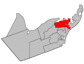
Bathurst is a geographic parish in Gloucester County, New Brunswick, Canada.

<span class="mw-page-title-main">New Bandon Parish, New Brunswick</span> Parish in New Brunswick, Canada

New Bandon is a geographic parish in Gloucester County, New Brunswick, Canada.

<span class="mw-page-title-main">Caraquet Parish, New Brunswick</span> Parish in New Brunswick, Canada

Caraquet is a geographic parish in Gloucester County, New Brunswick, Canada.

<span class="mw-page-title-main">Shippegan Parish, New Brunswick</span> Parish in New Brunswick, Canada

Shippegan is a geographic parish in Gloucester County, New Brunswick, Canada. Located in the northeastern corner of the province at the end of the Acadian Peninsula, the parish consists of the three main islands of Taylor, Lamèque, and Miscou, along with several smaller islands and tidal wetlands; Taylor Island is now joined to the mainland by an isthmus, which is crossed by a causeway.

<span class="mw-page-title-main">Saint-Isidore Parish, New Brunswick</span> Parish in New Brunswick, Canada

Saint-Isidore is a geographic parish in Gloucester County, New Brunswick, Canada.

<span class="mw-page-title-main">Allardville Parish, New Brunswick</span> Parish in New Brunswick, Canada

Allardville is a geographic parish in Gloucester County, New Brunswick, Canada,

<span class="mw-page-title-main">Wellington Parish, New Brunswick</span> Parish in New Brunswick, Canada

Wellington is a geographic parish in Kent County, New Brunswick, Canada.

<span class="mw-page-title-main">Peel Parish, New Brunswick</span> Parish in New Brunswick, Canada

Peel is a geographic parish in Carleton County, New Brunswick, Canada, situated on the eastern bank of the Saint John River.

<span class="mw-page-title-main">Woodstock Parish, New Brunswick</span> Parish in New Brunswick, Canada

Woodstock is a geographic parish in Carleton County, New Brunswick, Canada, surrounding the town of the same name on its landward side.

<span class="mw-page-title-main">Dumbarton Parish, New Brunswick</span> Parish in Canada

Dumbarton is a geographic parish in Charlotte County, New Brunswick, Canada, located inland north of St. George and south of Harvey.

<span class="mw-page-title-main">Saint Stephen Parish, New Brunswick</span> Parish in Canada

Saint Stephen is a geographic parish in Charlotte County, New Brunswick, Canada, located in the southwestern corner of the province.

<span class="mw-page-title-main">Saint James Parish, New Brunswick</span> Parish in Canada

Saint James is a geographic parish in Charlotte County, New Brunswick, Canada, located north of St. Stephen.

<span class="mw-page-title-main">Saint David Parish, New Brunswick</span> Parish in Canada

Saint David is a geographic parish in Charlotte County, New Brunswick, Canada, located northeast of St. Stephen and northwest of Saint Andrews.

References

  1. 1 2 "Census Profile". Statistics Canada. 26 October 2022. Retrieved 30 October 2022.
  2. 1 2 "Chapter T-3 Territorial Division Act". Government of New Brunswick. Retrieved 7 February 2023.
  3. "Chapter I-13 Interpretation Act". Government of New Brunswick. Retrieved 7 February 2023.
  4. The Territorial Division Act [2] divides the province into 152 parishes, the cities of Saint John and Fredericton, and one town of Grand Falls. The Interpretation Act [3] clarifies that parishes include any local government within their borders.
  5. 1 2 3 4 5 6 "Acadian Peninsula Regional Service Commission: RSC 4". Government of New Brunswick. Retrieved 7 February 2023.
  6. 1 2 3 "Chaleur rural district: RD 3". Government of New Brunswick. Retrieved 7 February 2023.
  7. "Regions Regulation – Regional Service Delivery Act". Government of New Brunswick. 21 July 2022. Retrieved 7 February 2023.
  8. "Paquetville Parish". Provincial Archives of New Brunswick. Retrieved 23 October 2020.
  9. "Paquet, Joseph-Marie". Dictionary of Canadian Biography. Retrieved 23 October 2020.
  10. "60 Vic. c. 49 An Act to divide the Parish of Caraquet, in the County of Gloucester, into two Separate Parishes.". Acts of the General Assembly of Her Majesty's Province of New Brunswick. Passed in the Month of March, 1897. Fredericton: Government of New Brunswick. 1897. pp. 362–365. Available as a free ebook from Google Books.
  11. "2 Edward 7 c. 29 An Act to amend Chapter 8 of 59 Victoria intituled 'An Act to revise and codify an Act to provide for the division of the Province into Counties, Towns and Parishes' for the purpose of re-establishing a correct line between the City of Saint John and the Parish of Simonds at Drury Cove (so called) in the City and County of Saint John.". Acts of the Legislative Assembly of His Majesty's Province of New Brunswick. Passed in the Month of April, 1902. Fredericton: Government of New Brunswick. 1902. pp. 102–103. Available as a free ebook from Google Books.
  12. "5 Geo. VI c. 54 An Act to amend an Act respecting the Division of the Province into Counties, Towns, and Parishes, so far as it relates to the County of Gloucester.". Acts of the Legislative Assembly of New Brunswick Passed During the Session of 1941. Fredericton: Government of New Brunswick. 1941. pp. 139–143.
  13. 1 2 3 4 "No. 017". Provincial Archives of New Brunswick. Department of Natural Resources and Energy Development. Retrieved 8 June 2021. Remainder of parish on maps 18, 29, and 30 at same site.
  14. 1 2 3 4 "054" (PDF). Transportation and Infrastructure. Government of New Brunswick. Retrieved 8 June 2021. Remainder of parish on mapbooks 073, 074, 093, and 094 at same site.
  15. "Local Service Districts Regulation - Municipalities Act". Government of New Brunswick. 25 June 2021. Retrieved 7 February 2023.
  16. "2021 Local Government Statistics for New Brunswick" (PDF). Department of Environment and Local Government. p. 58. Retrieved 7 August 2021.
  17. "Regulation 86-1 under the Municipalities Act (O.C. 86-2)". The Royal Gazette. 144. Fredericton: The Queen's Printer: 95–103. 22 January 1986.
  18. "Regulation 94-138 under the Municipalities Act (O.C. 94-741)". The Royal Gazette. 162. Fredericton: The Queen's Printer: 1434–1436. 16 November 1994.
  19. "Regulation 69–95 under the Municipalities Act (O. C. 69–986)". The Royal Gazette. 127. Fredericton: 599. 8 October 1969.
  20. "Regulation 88-149 under the Municipalities Act (O.C. 88-578)". The Royal Gazette. 146. Fredericton: The Queen's Printer: 1023–1025. 27 July 1988.
  21. "Regulation 2014-35 under the Municipalities Act (O. C. 2014-86)" (PDF). The Royal Gazette. 172. Fredericton: 656–659. 16 April 2014. ISSN   1714-9428.
  22. 1 2 3 "Search the Canadian Geographical Names Database (CGNDB)". Government of Canada. Retrieved 7 July 2021.
  23. "Explore New Brunswick's Protected Natural Areas". GeoNB. Retrieved 2 July 2021.
  24. "New Brunswick Regulation 94-43 under the Fish and Wildlife Act (O.C. 94-231)". Government of New Brunswick. 5 June 2006. Retrieved 8 July 2021.
  25. "2021 Community Profiles". 2021 Canadian Census . Statistics Canada. 4 February 2022. Retrieved 27 April 2022.
  26. "2016 Community Profiles". 2016 Canadian Census . Statistics Canada. 12 August 2021. Retrieved 30 August 2019.
  27. "2011 Community Profiles". 2011 Canadian Census . Statistics Canada. 21 March 2019. Retrieved 6 April 2014.
  28. "2006 Community Profiles". 2006 Canadian Census . Statistics Canada. 20 August 2019.
  29. "2001 Community Profiles". 2001 Canadian Census . Statistics Canada. 18 July 2021.
  30. 1 2 Statistics Canada: 1996, 2001, 2006, 2011 census
  31. 2011 Statistics Canada Census Profile: Paquetville Parish, New Brunswick
  32. "Corrections and updates: Population and dwelling count amendments, 2011 Census". Statistics Canada. 14 February 2013. Retrieved 15 February 2013.
  33. "Census Profile, 2016 Census Paquetville, Parish [Census subdivision], New Brunswick". Statistics Canada. Retrieved 30 August 2019.


47°37′30″N65°12′54″W / 47.62500°N 65.21500°W / 47.62500; -65.21500 (Paquetville Parish, New Brunswick)