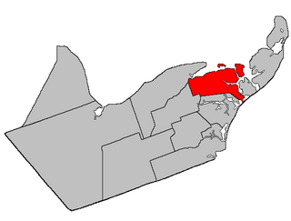
Allardville | |
---|---|
Coordinates: 47°29′N65°30′W / 47.48°N 65.5°W | |
Country | Canada |
Province | New Brunswick |
County | Gloucester |
Erected | 1947 |
Area | |
• Land | 654.60 km2 (252.74 sq mi) |
Population (2021) [1] | |
• Total | 1,949 |
• Density | 3.0/km2 (8/sq mi) |
• Change 2016-2021 | 4.1% |
• Dwellings | 919 |
Time zone | UTC-4 (AST) |
• Summer (DST) | UTC-3 (ADT) |
Allardville is a geographic parish in Gloucester County, New Brunswick, Canada, [4]
It is divided for governance purposes into the town of Hautes-Terres [5] in the east and the Chaleur rural district in the west. [6] Hautes-Terres is a member of the Acadian Peninsula Regional Service Commission and the Chaleur RD is a member of the Chaleur RSC. [7]
Prior to the 2023 governance reform, the Hautes-Terres portion formed the local service district of Saint-Sauveur, while the Chaleur RD portion formed the LSD of the parish of Allardville. [8]
The parish was named in honour of Monsignor Jean-Joseph-Auguste Allard, who brought new settlers from the East Bathurst area in 1932. [9]
Allardville was erected in 1947 [10] from parts of Bathurst, Saint-Isidore, and Saumarez Parishes. This was the last new parish to be erected in New Brunswick.
Allardville Parish is bounded: [2] [11] [12]
The parish's two LSDs sat side-by-side, with the boundary running northwesterly along grant lines about 8.1 kilometres easterly of the junction of Route 134 and Route 160 and prolongated northwesterly and southeasterly to the parish line. [8] Both LSDs assessed for street lighting and community & recreation services in addition to basic LSD services. [13]
Saint-Sauveur (established 1985) [14] was the eastern LSD, taking its name from its westernmost community. The population in 2016 was 673. [15]
Allardville (established 1999) [16] was the western LSD. This LSD actually extends north to included part of Bathurst Parish; census data does not profile the extended area. Allardville was formed by merging three previous entities:
Governance reforms planned for 2023 [20] would move Saint-Sauveur to the Acadian Peninsula Regional Service Commission, where it would form a local government entity with the villages of Paquetville and Saint-Isidore and the LSDs of the parish of Paquetville and the parish of Saint-Isidore. Allardville would remain part of the Chaleur RSC and be included in its rural district. These reforms are scheduled to take effect in 2023.
Communities at least partly within the parish; [11] [12] [21] [22] (brackets) indicate the LSD; italics indicate a name not used on modern provincial government maps
Bodies of water [lower-alpha 1] at least partly within the parish. [11] [12] [21]
|
|
Parks, historic sites, and related entities at least partly within the parish. [11] [12] [21] [23]
Revised census figures based on the 2023 local governance reforms have not been released.
2021 | 2016 | 2011 | |
---|---|---|---|
Population | 1,949 (-4.1% from 2016) | 2,032 (-2.4% from 2011) | 2,081 (-3.3% from 2006) |
Land area | 654.60 km2 (252.74 sq mi) | 654.69 km2 (252.78 sq mi) | 655.21 km2 (252.98 sq mi) |
Population density | 3/km2 (7.8/sq mi) | 3.1/km2 (8.0/sq mi) | 3.2/km2 (8.3/sq mi) |
Median age | 53.6 (M: 53.2, F: 54.0) | 49.6 (M: 48.7, F: 50.6) | 47.0 (M: 46.3, F: 48.0) |
Private dwellings | 919 (total) 878 (occupied) | 932 (total) | 909 (total) |
Median household income | $58,400 | $52,779 | $43,501 |
|
|
| |||||||||||||||||||||||||||
[30] [31] [32] |
Canada Census Mother Tongue – Allardville Parish, New Brunswick [30] | ||||||||||||||||||
---|---|---|---|---|---|---|---|---|---|---|---|---|---|---|---|---|---|---|
Census | Total | French | English | French & English | Other | |||||||||||||
Year | Responses | Count | Trend | Pop % | Count | Trend | Pop % | Count | Trend | Pop % | Count | Trend | Pop % | |||||
2011 | 2,060 | 1,970 | 3.0% | 95.63% | 65 | 0.0% | 3.16% | 25 | n/a% | 1.21% | 0 | 100.0% | 0.00% | |||||
2006 | 2,135 | 2,030 | 11.9% | 95.08% | 65 | 45.8% | 3.04% | 0 | 100.0% | 0.00% | 40 | n/a% | 1.87% | |||||
2001 | 2,440 | 2,305 | 12.0% | 94.47% | 120 | 0.0% | 4.92% | 15 | 50.0% | 0.61% | 0 | 0.0% | 0.00% | |||||
1996 | 2,750 | 2,620 | n/a | 95.27% | 120 | n/a | 4.36% | 10 | n/a | 0.36% | 0 | n/a | 0.00% |
Saumarez is a geographic parish in Gloucester County, New Brunswick, Canada.
Beresford is a geographic parish in Gloucester County, New Brunswick, Canada.
Inkerman is a geographic parish in Gloucester County, New Brunswick, Canada.
Wicklow is a geographic parish in Carleton County, New Brunswick, Canada, forming the northwestern corner of Carleton County.
Dalhousie is a geographic parish in Restigouche County, New Brunswick, Canada.
Bathurst is a geographic parish in Gloucester County, New Brunswick, Canada.
New Bandon is a geographic parish in Gloucester County, New Brunswick, Canada.
Paquetville is a geographic parish in Gloucester County, New Brunswick, Canada.
Caraquet is a geographic parish in Gloucester County, New Brunswick, Canada.
Saint-Isidore is a geographic parish in Gloucester County, New Brunswick, Canada.
Saint-Paul is a geographic parish in Kent County, New Brunswick, Canada.
Saint Marys is a geographic parish in York County, New Brunswick, Canada.
Hillsborough is a geographic parish in eastern Albert County, New Brunswick, Canada.
Elgin is a geographic parish in the interior of Albert County, New Brunswick, Canada, the only one of the county's parishes that does not border either the Bay of Fundy or the Petitcodiac River.
Saint George is a geographic parish in Charlotte County, New Brunswick, Canada, located between St. Stephen and Saint John.
Dumbarton is a geographic parish in Charlotte County, New Brunswick, Canada, located inland north of St. George and south of Harvey.
Saint Patrick is a geographic parish in Charlotte County, New Brunswick, Canada, located west of St. George and Saint Andrews.
Saint Stephen is a geographic parish in Charlotte County, New Brunswick, Canada, located in the southwestern corner of the province.
Saint James is a geographic parish in Charlotte County, New Brunswick, Canada, located north of St. Stephen.
Saint David is a geographic parish in Charlotte County, New Brunswick, Canada, located northeast of St. Stephen and northwest of Saint Andrews.